Discussion on problems in urban cadastral mapping and real estate mapping
Combining the urban construction status and the development requirements of surveying and mapping, focusing on the analysis of problems in cadastral surveying and mapping and real estate surveying and mapping can make the corresponding surveying and mapping work more efficient and scientific, give full play to the actual role of cadastral and real estate surveying and mapping, and inject more vitality into urban construction and development. Therefore, in the process of refining the research content of urban surveying and mapping, we should pay more attention to cadastral surveying and mapping and real estate surveying and mapping, deeply discuss the existing problems, find out the corresponding measures to deal with, so as to make the implementation of surveying and mapping work in urban construction more effective, and realize the scientific application of rich surveying and mapping results.
1.Overview of cadastral mapping and real estate mapping
1.1 Overview of cadastral mapping
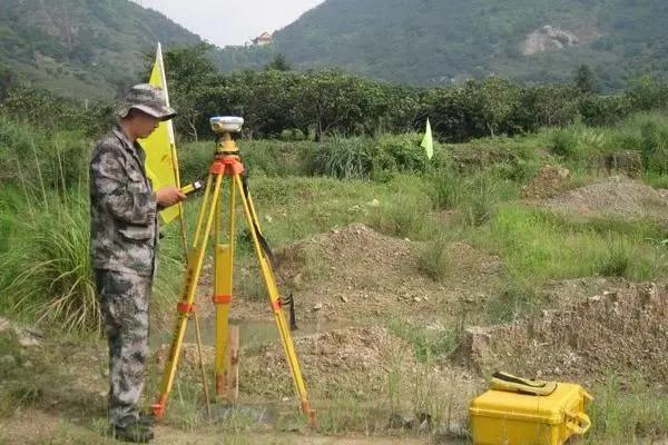
Cadastral mapping mainly includes cadastral control survey, boundary point survey and cadastral mapping. In practice, through thinking about the scientific use of conventional ground survey methods, satellite positioning methods, satellite and ground survey technology, photogrammetry and other technologies, it is beneficial to enhance the effect of cadastral mapping, and provide professional support for the realization of urban scientific construction goals and long-term development. At the same time, through the comprehensive consideration of the introduction and application of cadastral surveying and mapping, it is beneficial to enrich the technical connotation in the development of surveying and mapping, realize the scientific application of cadastral maps, and ensure the good construction and development of modern cities in practice.
1.2 Overview of Real Estate Mapping
Real estate refers to the general name of the land parcel with ownership nature and the buildings on it. In the process of strengthening real estate surveying and mapping, it is necessary to pay attention to the integration and utilization of the professional theoretical knowledge of surveying and mapping, and complete the real estate surveying and mapping operation with the support of engineering surveying, so as to provide necessary support for the enhancement of urban construction effect and enrichment of content, and better promote the development of surveying and mapping field. At the same time, with the cooperation of different elements such as good surveying and mapping concept and mechanism, the quality of real estate surveying and mapping can be more reliable, the corresponding surveying and mapping operation plan can be completed, and the utilization value of real estate surveying and mapping in urban development can be better reflected.
2.Analysis of problems in urban cadastral mapping and real estate mapping
2.1 The reasonable application of surveying and mapping technology is not paid enough attention
In the process of urban cadastral and real estate surveying and mapping, due to the lack of enough attention to the rational use of surveying and mapping technology, the implementation effect of the corresponding operation plan is not significant, which affects the use value of surveying and mapping results. The specific performance is as follows:
(1) Due to the insufficient attention paid to the introduction and role of GPS mapping technology and remote sensing mapping technology, the problem rate of cadastral mapping and real estate mapping in the application of urban construction has increased, which is difficult to meet the requirements of accurate measurement in the development of mapping operations;
(2) Influenced by the insufficient attention paid to the rational application of surveying and mapping technology, the effect and application quality of urban cadastral surveying and mapping and real estate surveying and mapping are lack of technical guarantee, which hinders the sustainable development of modern cities and restricts the improvement of technical level in surveying and mapping operations.
2.2 Mapping mechanism needs to be improved
Through comprehensive consideration of urban construction and development requirements, in the process of cadastral surveying and mapping and real estate surveying and mapping, the existing surveying and mapping mechanism is not perfect and the application is not applicable, leading to the failure of surveying and mapping operations to achieve the desired results. The specific performance is as follows:
(1) Due to the lack of consideration of the application of refinement and innovation ideas in cadastral surveying and mapping and real estate surveying and mapping, the relevant surveying and mapping mechanism has lagged behind, which has a negative impact on the surveying and mapping effect in urban construction;
(2) When the surveying and mapping mechanism is not perfect, it will lead to the lack of scientific guidance in the urban cadastral surveying and mapping and real estate surveying and mapping operations, virtually reducing the efficiency of these aspects of surveying and mapping.
2.3 Other problems
Based on the research of urban cadastral and real estate mapping, we also need to understand the existing problems in these areas:
(1) Due to the lack of professional ability and sense of responsibility of some surveying and mapping personnel, the implementation of cadastral mapping and real estate mapping plans lacks professional support, which will reduce the level of professional mapping in these areas;
(2) Because the existing surveying and mapping system is not perfect, the cadastral and real estate surveying and mapping operations are lack of effectiveness, which affects the use value of surveying and mapping results and the quality of urban construction.
3.Relevant measures to strengthen urban cadastral mapping and real estate mapping
3.1 Pay attention to the rational application of surveying and mapping technology
In the process of promoting the development of urban construction and giving full play to the practical role of cadastral surveying and mapping and real estate surveying and mapping, we need to deal with it from the technical level. During this period, we should:
(1) attach importance to the introduction and efficient use of GPS surveying and mapping technology. Compared with traditional human surveying and mapping or other surveying and mapping technologies, GPS surveying and mapping technology can not only save human resources, but also avoid consuming too much material resources and funds as much as possible,
and enhance the positioning accuracy in cadastral surveying and mapping and real estate surveying and mapping;
(2) Strengthen the use of remote sensing surveying and mapping technology, provide technical support for the continuous optimization of urban cadastral surveying and mapping and real estate surveying and mapping methods, meet the requirements of scientific response to surveying and mapping problems in these areas, obtain surveying and mapping results with great reference value, and bring more impetus to the development of modern cities;
(3) The high-accuracy tilting photography technology scheme of low altitude UAV is used to understand the measured urban cadastral and real estate area, divide the aerial photography block based on the UAV's endurance and mapping accuracy, and do a good job in the layout of target control points. At the same time, it is necessary to develop a feasible UAV flight plan on the basis of efficiency, to ensure that the overlap degree can meet the requirements of six standards: first, the overlap degree of course should be controlled within 65% to 85%, and the minimum should not be less than 60%. Second, the lateral overlap shall be controlled within 45% to 80%, and the minimum shall not be less than 40%. Third, the deflection angle of the photo rotation shall not exceed 15 °. Fourth, the maximum rotation angle must be controlled below 25 ° on the basis of ensuring that the overlap between the photo heading and the side direction meets the standard requirements. Fifth, there shall be no less than two baselines whose heading covers the boundary line of the camera area. Sixth, the image amplitude of side coverage beyond the boundary line of the camera area shall not be less than 50%. The accuracy of surveying and mapping results can be effectively ensured only by accurately grasping these six standards.
3.2 Focus on continuous improvement of surveying and mapping mechanism
Through the analysis and consideration of the current situation of urban cadastral surveying and mapping and real estate surveying and mapping, in order to reduce the incidence of surveying and mapping problems in these aspects, it is necessary to consider the continuous improvement of surveying and mapping mechanism. During this period, we should:
(1) integrate the concept of refinement and innovation into the formation of cadastral surveying and mapping and real estate surveying and mapping mechanisms, and constantly improve such systems to make surveying and mapping more reasonable in urban development;
(2) When the urban cadastral and real estate surveying and mapping mechanism is gradually improved, it needs to be implemented in place to meet the requirements for efficient development of corresponding surveying and mapping operations, and give more support to the scientific development of surveying and mapping in urban construction.
3.3 Treatment measures in other aspects
In order to effectively deal with the problems in urban cadastral surveying and mapping and real estate surveying and mapping, we also need to attach importance to the use of these handling measures:
(1) Actively carry out professional training activities, implement a good incentive and responsibility mechanism, strengthen the sense of responsibility of surveying and mapping personnel, improve their basic quality and professional ability, so as to lay a foundation for improving the professional level of urban cadastral and real estate surveying and mapping;
(2)Improve the cadastral surveying and mapping and real estate surveying and mapping system, implement them in place, meet the requirements for efficient implementation of corresponding surveying and mapping operations, comprehensively enhance the development potential of the city in future practice, maintain the good utilization of rich surveying and mapping results, provide more support for the realization of surveying and mapping objectives in urban construction, and make the role of cadastral surveying and mapping and real estate surveying and mapping more obvious in practice.
4 Conclusion
To sum up, through the analysis and treatment of different problems, it is conducive to the scientific application of cadastral surveying and mapping and real estate surveying and mapping, meeting the requirements of modern urban scientific construction, and obtaining accurate surveying and mapping results. Therefore, in the future, in the process of improving the level of urban cadastral surveying and mapping and real estate surveying and mapping, and enhancing the implementation effect of the corresponding surveying and mapping work, we should pay more attention to the problems in these aspects of surveying and mapping, and deal with them in a timely manner with the support of practical and effective measures, so as to lay a foundation for the sustainable development of modern cities.