What role does 3D GIS play in the construction of smart cities

With the development of information technology, the development of digital cities is rapidly moving towards smart cities. Smart city is based on the digital city, through the Internet and a series of smart applications, to let users get a more comprehensive experience; At the same time, driven by technology, the informatization characteristics of cities will be more prominent. The application of 3D GIS technology in smart cities can integrate the geographical information of cities, better display the digital layout of cities, and promote the development of cities.
3D GIS technology has great advantages in the application of smart cities. Most of the traditional forms of information are based on two-dimensional geographic information data. On the basis of two-dimensional geographic information, adding GIS technology can turn two-dimensional information into three-dimensional, which greatly improves the carrying capacity and expression effect of information, also greatly improves the accuracy of data, and makes the construction and operation of smart cities more stable; Secondly, the application of 3D GIS technology has also greatly enhanced its visualization effect, enabling urban managers to grasp the geomorphic characteristics and spatial layout of various regions, and have a more direct understanding of the urban conditions in 3D models.
Existing problems in the application of 3D GIS technology in smart cities
1.Not paying enough attention to the development of smart cities
Although the level of information technology in China has been rapidly improved, some cities still do not pay enough attention to the development and construction of smart cities supported by information technology, and have not found a feasible way to develop smart cities. To some extent, it has affected the construction effect of smart cities.
2.The application of GIS technology is not sophisticated enough
In the process of smart city construction in some cities, due to the lack of professional and technical personnel, the application of 3D GIS technology is not sufficient and can not achieve the desired effect. Moreover, the lack of training of professional and technical personnel is also a prominent problem in the development of smart cities in some cities.
Application of 3D GIS technology in smart city
1.Application of 3D GIS in urban emergency management
The application scope of GIS technology is becoming wider and wider, and it also plays an important role in urban public transport system monitoring and residential area monitoring. After the application of GIS technology, these areas that need to be monitored can be more accurately monitored to improve the management effect. For example, after using Internet+GIS technology for residential areas, once abnormal conditions are found in residential areas, signals can be transmitted to relevant departments through the network in a timely manner.
2.Application of Internet of Things technology in smart city transportation
Traffic travel is closely related to people's daily life. How to provide travel convenience for urban residents through information technology, make full use of traffic resources, avoid traffic congestion and a series of other problems that affect the travel experience, has become one of the key issues to be solved in smart cities. With the help of Internet of Things technology, the operation of the entire urban traffic can be monitored and managed in real time to ensure the orderly and stable operation of urban traffic.
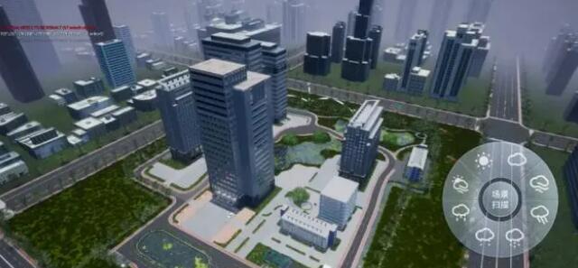
3.High-performance 3D GIS visualization system
Realistic visualization of 3D GIS data emphasizes the real-time, low latency, stable image quality and realistic scene effect of human-computer interaction response. The 3D GIS visualization engine makes full use of the latest achievements of computer graphics research, and realizes the local dynamic loading and optimization of 3D spatial data throughout the city based on the efficient 3D spatial data organization and management and dynamic scheduling mechanism.