Evolution of Web GIS: development stage, trend and direction
Network mapping and online use of geospatial information have developed rapidly in the past few decades. Almost everyone in the world uses map information, whether one is aware of it or not. Now almost every mobile phone has a location service, and every event and object on the earth has a location. Due to the development of the Internet, the use of this geospatial location data has expanded rapidly. A large amount of geospatial data can be obtained online and used for network applications and maps to view, analyze, model and simulate. This article reviews the development of webGIS, from the first static online map image to the current highly interactive multi-source web map services, which have been increasingly transferred to cloud computing platforms. WebGIS realizes the integration and online interaction among the three components of geospatial information, personnel and functions. This paper attempts to study the trend and interaction between these components in combination with the development of technology, and finally discusses some opportunities and directions.
History
The speech of the United States Vice President Al Gore on digital earth technology in 1998 raised people's awareness of the value of geospatial information and the need for its availability on the Internet and access by many users around the world. Gore's vision is to use technology and people to create immersive visual experience in virtual geographic space and time to understand our planet. He pointed out his concern about the application of virtual diplomacy, combating crime, protecting biodiversity, forecasting climate change and improving agricultural productivity. Interestingly, in the past two decades, technology and collaborative environment have made great progress, combining people and information, including digital earth, high-speed communication network, mobile wireless network, location-based services, cloud computing and Web GIS.
However, we still face many challenges and obstacles, including connecting information to the surrounding geographical location, analyzing and processing large geospatial data, discovering and interpreting intelligent information, immersing in our digital earth, taking advantage of crowdsourcing opportunities, and disseminating information to the global public in a visual and easy-to-understand way. Since the beginning of the Internet and the first World Wide Web Conference in 1994, the interaction between information and people has undergone tremendous changes. Today's network is not only a content technology under development, but also involves content generation, communication and collaboration.
The continuous development of new user needs has been met in further technology development, which in turn has led to wider use and increased user needs, thus forming an iterative cycle of technology development and user application growth and expansion. In addition, from a technical point of view, the methods and tools for providing maps online have changed greatly. The early origin of the Web GIS application is a "simple" tool that allows organizations and individuals to publish maps. The user's choice is limited to browsing, zooming, panning and turning off layers. Although users are active readers of data, they are passive in uploading information to maps and conducting spatial analysis. Today, Web GIS applications have introduced a wider range of functions, including those provided by traditional desktop GIS, but are still expanding to include the growing application requirements, and have the advantage of sharing content and the ability to analyze network map data. In this article, we will outline the evolution of Web GIS, taking into account the views of designers (experts, scientists) and users (novices and occasional users).
Connotation of Web GIS
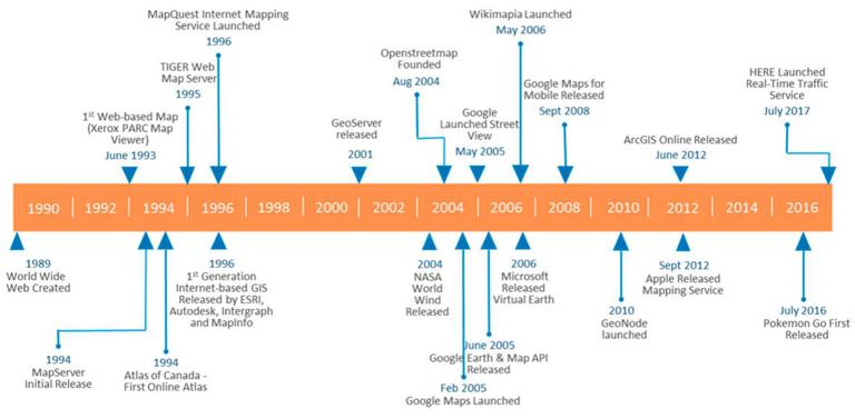
What is Web GIS? In addition to the accepted scientific and technical definitions, we can refer to the content provided by Wikipedia. Web GIS contains three basic elements: geographic data, geographic information and its visualization (map), geospatial software and the Internet. Web GIS is the most common form of online GIS. The development of network maps began immediately after the creation of the network, mainly in the form of published online maps. Among them, PARC Map Viewer is the first web-based map. Up to now, Web GIS has reached an unimaginable level 20 years ago, which is mainly due to the progress of web technology.
In the development of the web, the web is usually identified by different authors using four generations called web 1.0 to web 4.0 (and later versions). Generation after generation of general web development has laid the foundation for web GIS development, which has gone through some different but interrelated or overlapping stages.
Development stage
The early web GIS experienced the stages of static map publishing, static web GIS and interactive web GIS. In recent years, the following three factors have formed the basis for the development of early web GIS: First, under the promotion of the release of free satellite images and the occurrence of major disaster events, the use of mapping and GIS technology to manage and respond to such events has significantly improved the public's understanding of GIS; The second is the emergence of new Internet technologies, namely AJAX and map tile technology, both of which focus on reducing the response time of network maps. Third, location-based services based on wireless networks enable users to access geographic information systems and cartography technology.
According to the technical types supporting the map, the five-generation network map is determined. The first generation of maps is static map, such as the map created by Xerox's parc map server. They are static maps embedded in HTML files and can be accessed by simple clicking through hyperlinks. The hyperlink selects the map to view for the user. The next generation includes dynamic HTML maps created dynamically using Java and ActiveX. At that time, the map user interface began to display similar to GIS interface.
However, the function is limited to map browsing and simple query. The third generation of web GIS is driven by the development of asynchronous JavaScript and XML (AJAX) technology, which shortens the response time and paves the way for direct interaction between users and maps. This provides a way for open service application programming interfaces (Api). During the generation of mashups, you can access these interfaces and combine them with the data contributed by users. Finally, the fourth generation focuses on the virtual earth sphere, such as NASA World Wind, Google Earth and Microsoft Bing, which provide users with a more realistic and immersive 3D earth experience.
The emergence of the first public network services that cover global digital images has opened up the geospatial world to draw public maps of the world through the Internet. Its ability to generate maps is far beyond the scope of a small group of web developers and cartographers. The fifth generation, based on cloud computing, rich Internet applications (RIA) and crowdsourcing, allows users to access cloud computing resources and services instead of focusing on obtaining sufficient hardware resources and downloading desktop software, which now includes, for example, Amazon cloud storage and web services, Microsoft Azure cloud and ESRIArcGIS online.
The network first emerged as a file network, then turned into a social network for people, and now developed into a data and social network. The latter transition of the network focuses on the stronger connection between people and data, that is, the interaction between people around information and knowledge, including collaborative mapping, location-based and mobile activities, dynamic processes and interaction in geographical environments. With the continuous development of web technology, including in the field of geospatial, people are still guessing what content the future web development may contain. People pay more and more attention to human-computer interaction with automatic and semi-automatic decision-making.
Development trend
In the past few decades, the development of network map has gone through some important stages, and each stage has a significant impact on the use and further development of network map. These developments involve technology and users. The technology under development provides a shared platform (static and cloud era); Improve response time to data requests (dynamic, service and interactive era); Provide richer interfaces for data access (to affect data accessibility); Based on earth, mobile, positioning and intelligence, support data, function and service generation (interactive, digital earth, LBS, intelligent). By analyzing the development and progress of each stage, we can collect some trends and generate potential directions to determine the future of web GIS.
Data is transferred from the desktop environment to the cloud. In the early era of network cartography, geospatial data and maps were generated by professionals (for example, geographic information system digitization, surveying, photogrammetry and remote sensing), and the amount of data captured was relatively small, which was limited by the low data of computer network bandwidth and infrastructure. In the era of cloud computing, more and more data is captured and stored somewhere in the cloud. More and more devices online through IoT begin to contribute more data to the network, including location-based data. The trend of data transfer from the desktop environment to the cloud and the increasing amount of data captured through mobile, sensor and social media communication platforms. A large part of these data are geospatial images and features. In 2014, Google Maps had more than 1 billion users per month, accounting for 41% of the global Internet users.
The breadth and complexity of the functions of network geospatial data have been widely developed in the era of network mapping. From a simple static map, as an online image, it has developed into a Web GIS system with all-round GIS functions. With the development of interactive and collaborative web mapping era, users can not only retrieve, but also use asynchronous client/server technology to capture, edit, store and analyze geospatial data. The era of network map services provides map servers with not only map image services, but also geospatial data and processing services. This makes GIS functions available online, as is the case with MapQuest.
The development of digital earth has introduced map tile technology into highly interactive 2D and 3D geographic browsers. The development of cloud-based technology provides the infrastructure for online hosting of data and functions, and brings about the rapid development of web cartography and web GIS. By implementing the architecture of web database and geographic processing services in the cloud, more GIS functions can be integrated into a real Web GIS online platform, making it easier for global users to access.
The emerging online map and GIS environment has begun to provide more support for increasing user sharing, collaboration and team-based content, including real-time sharing environment, synchronization of collaborators in different locations and simultaneous map sharing and geographic processing.
More and more data, information and knowledge are captured and derived, which requires strengthening management, function, analysis and modeling. What does it mean for the direction and future of web map and geospatial applications? The number of data and information on the network continues to surge. Its sources include aviation and satellite images, crowdsourcing data, online databases, sensors, and data sources from the Internet of Things. Data will be so important in the next few years that "organizations that do not use data intelligently will not survive". Web GIS will continue to be an important part of data science, because space/time is the basic key of events, and visualization will still be one of the most powerful tools for interpreting and linking data, information, knowledge and information.
Summary
With the increasing saturation of global geospatial network users, the number of users will increase in the future, and these users will use more and more applications. More and more applications and applications from more diverse disciplines will use geospatial information integrated in their business and consumer workflow and decision-making processes. The challenge of future development is to provide information and knowledge in a comprehensive, visual and even automated environment to make consumption easy and transparent. So what will this integrated and visual environment look like?
According to some characteristics, it can help to define this environment, namely, authenticity, collaboration and personalization. This means that users will be involved and immersed in the environment they can contact, and related to their problems or decisions. Regardless of their geographical location, they will be able to contact others and cooperate in joint projects and tasks. They will be able to access information related to their queries and tasks. To be true, the geospatial network environment must allow users to participate in and immerse themselves in realistic 3D and 4D experiences involving real-world processes, problem solving and decision-making. In this environment, users participate in the sharing applications in space and time.
Geospatial network environment will also be more personalized and intelligent for users in the future. Personalization includes understanding the requirements of users and the requirements of the applications and tasks they are involved in. Users with different backgrounds and skill levels from different disciplines and perspectives will be able to talk and participate in an integrated, personalized and semantic environment. Users constantly want better information, focus and filter their needs, and customize them according to their knowledge and skill level. This means that network mapping and geographic information systems and services need to be more intelligent, efficient and focused in order to support users and applications at the level of knowledge, intelligence and intelligence.