Application of remote sensing technology in marine surveying and mapping
1.Features of Remote Sensing Technology
(1) It can obtain a wide range of data information. The flight height of the aerial camera used for remote sensing can reach 10km, the orbit height of the Landsat can reach 910km, and the coverage of a Landsat image exceeds 30000 square kilometers.
(2) It can reflect the changes of ground objects. Remote sensing detection can make periodic and repeated observations in the same area, help people to obtain remote sensing data and realize dynamic tracking of ground changes, especially in monitoring weather conditions, natural disasters and military targets.
(3) Fast information acquisition. Remote sensing detection can be used to observe the earth in a large area from the air to the space in a short time, and obtain valuable remote sensing information. Considering that the satellite revolves around the earth, the latest data from the Ministry of Natural Environment of the region can also be obtained. Updating the original data is incomparable to manual field measurement.
(4) The data information is comprehensive. The data information obtained from remote sensing detection belongs to the data of the same period and a large range. These data can comprehensively present the ground objects and human phenomena, reflect the shape and distribution of various things on the earth, and clarify the correlation between geographical things.
(5) There are many ways to obtain information. According to different tasks, remote sensing technology can choose different equipment and bands to achieve information collection. With the different penetrability of different wavebands for objects, we can get the internal information of ground objects, such as deep ground, water under ice, ground objects under desert, etc. Microwave wavebands can realize all-weather operation.
2.Application of remote sensing technology in marine surveying and mapping
2.1 Environmental monitoring
UAV has the advantages of rapid mapping, in-depth high-risk areas, high resolution and high revisit rate. Its application in topographic mapping, environmental monitoring, bathymetry and marine voyage survey greatly improves the accuracy of mapping results.
Remote sensing technology is the main measure in the marine environment monitoring process. Its application in the marine environment monitoring process can effectively identify the types of beach garbage using high-resolution image data. Technicians can also build a three-dimensional model based on high-precision DEM, and in combination with the actual situation of the marine environment in the process of marine mapping using this technology to comprehensively monitor coastal zone erosion.
In order to strengthen the application of UAV, relevant researchers used a light UAV to take aerial photos of the marine environment, and analyzed the orthophoto data through photogrammetric methods. For example, the researchers took aerial photos of the beach in Wujiao Bay, Dongshan Island, using a low flying quad rotor UAV, and then made high-resolution orthophotos according to the actual aerial photos, thus strengthening the protection of the marine environment.
2.2 Application in marine element observation
Remote sensing technology can use the corresponding sensor equipment to conduct remote non-contact observation of the ocean, obtain the corresponding marine landscape information and marine element information, and present them in the form of data and images. The ocean will continuously radiate electromagnetic waves to the surroundings, and the sea surface will also reflect or scatter the electromagnetic wave energy from the sun and artificial radiation sources. Using this principle, some special sensors can be designed to cooperate with platforms such as artificial satellites, aircraft and hot air balloons to receive and record the above electromagnetic radiation energy, and then carry out corresponding transmission and processing to obtain ocean images and data.
2.3 Application in marine activity monitoring
The sea is an important place for many countries to carry out economic and military activities. In the process of carrying out these activities, it is necessary to record data effectively at the marine site. High frequency and low frequency radar has been widely used in the monitoring of marine economic activity areas because of its large detection area, long detection distance, all-weather, over the horizon and other characteristics.
2.4 Application in marine dynamic monitoring
Ocean dynamics is the key to shaping the marine environment, mainly including tides, winds and waves. With the help of remote sensing technology, global satellite positioning system and other technologies, the accurate acquisition of marine dynamic information can be achieved. Taking the ocean wind field observation as an example, the sea surface wind field data that can be obtained by using remote sensing technology is usually the observation data 20 nm away from the sea surface. These data can provide reference for typhoon forecast and wave forecast. In wave observation, the corresponding synthetic aperture radar can be used to retrieve the wave direction spectrum, and the corresponding dynamic model can also be used to solve the surface wavelength problem.
2.5 Sea surface height
The monitoring of sea level height is of great significance to the study of global sea level rise caused by climate phenomena such as global warming, melting of polar glaciers, and thermal expansion of upper sea water. Satellite altimeter is a radar that transmits pulses to the earth below the satellite. By measuring the round-trip time after the pulse is reflected by the sea surface, the height of the satellite from the sea surface can be obtained. Through ground orbit ranging and calculation, the satellite orbit height can be obtained, so as to obtain the satellite remote sensing sea surface height value.
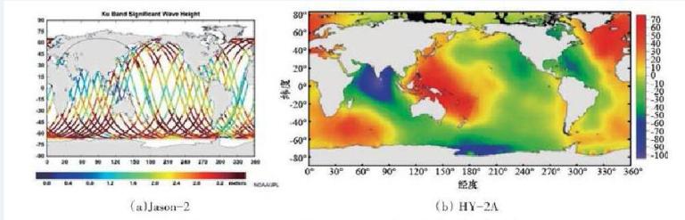
Internationally, Europe and the United States have launched a series of altimeter satellites, which are widely used in military and civilian applications, including the altimeter satellite (Jason-2). HY-2 01 satellite (HY-2A) is the first marine dynamic environment satellite in China. Its main loads include radar altimeter, microwave scatterometer, microwave radiometer and atmospheric correction radiometer. HY-2A radar altimeter is a dual frequency radar altimeter with a transmission frequency of 13.58 GHz ± 160 MHz and 5.25 GHz ± 160 MHz. It measures the sea surface height, significant wave height and sea surface wind speed in a pulse limited working mode. The height measuring accuracy of the instrument is 4 cm under the condition of 20 m significant wave height, and 2 cm under the condition of 4 m significant wave height. The height measuring accuracy level is equivalent to that of the Jason-2 satellite altimeter. Figure 1 shows the sea surface height products measured by Jason-2 (Figure 1 (a)) and HY-2A (Figure 1 (b)) satellites respectively.
Conclusion
In a word, the society's demand for energy resources continues to grow, so the marine development has entered a new stage. In the process of developing marine resources, we need to use remote sensing technology to monitor the corresponding marine environment and protect the marine ecological environment, so as to ensure the sustainable use of marine resources while promoting the smooth implementation of marine undertakings.