The core issues of geographic information system can be summarized into five aspects: location, conditions, trends, patterns and models.
1) Locations
That is, what is at a specific location.
First, the specific location of an object or regional information must be defined. Common methods for defining location include determining positions through various interactive means or directly inputting coordinates. Second, after specifying the location of a target or area, expected results and all or part of its characteristics can be obtained, such as current land parcel owner, address, land use status, valuation, etc.
2) Conditions
That is, where there is something that meets certain conditions.
First, you can specify a set of conditions, such as selecting from predefined options; filling in logical expressions; and interactively filling in forms on terminals.
Secondly, after specifying conditions, a list of all objects meeting the specified criteria can be obtained, such as highlighting all features on the screen that satisfy the given conditions. For example, houses located in residential areas, valued below $200,000, with four bedrooms, and constructed of wood.
3) Trends
This type of problem requires the integration of existing data to identify geographical phenomena that have already occurred or are undergoing changes.
First, identifying trends, though determining trends cannot, of course, guarantee correctness every time. Once a specific dataset is mastered, identifying trends may rely on assumptions, personal speculation, observed phenomena, or reported evidence.
Secondly, in view of this trend, we can confirm or negate it by analyzing the data. Geographic information systems allow users to quickly obtain quantitative data and charts illustrating the trend. For example, through GIS, the characteristics of this trend can be identified: how many citrus plots have been converted to other uses? What’s the use now? How many such changes have taken place in a region? How many years can this change be traced back? Which time period best reflects this trend? One year, five years or ten years? Has the rate of change increased or decreased?
4) Patterns
Such problems are related to the analysis of events that have occurred or are occurring. GIS combines existing data to better explain what is happening and find out which data is relevant to what happened.
Firstly, the determination of patterns usually requires long-term observation, familiarity with existing data and understanding of the potential relationship between data.
Secondly, after the mode is determined, a report can be obtained showing when and where the event occurred and a series of maps showing the event. For example, motor vehicle accidents often conform to a specific pattern, where does the pattern (accident) occur? Does the place of occurrence have anything to do with the time? Is it at a particular intersection? What are the conditions at these intersections?
5) Models
The solution of this kind of problem needs to establish a new data relationship to produce a solution.
Firstly, models are established, such as selection criteria, testing methods, etc.
Secondly, after establishing one or more models,which can generate a list that satisfies all the specific features, emphasizing the map of the selected features, and providing a detailed description of the selected features. For example, to build a children’s bookstore, the evaluation indicators for site selection may include 10, 15, 20 minutes of reachable space. The number of children aged 10 or under living nearby, the income of nearby families and potential competition around them.
To accomplish the aforementioned core tasks of a Geographic Information System, various functions need to be employed. Despite variations in the strengths and weaknesses of commercial GIS software packages and the differing technologies they use to implement these functions, most provide the following capabilities:
Data Acquisition
Preliminary data Processing
Storage and Retrieval
Search and Analysis
Display and Interaction
Figure 1-8 illustrates the relationships between these functions and their different manifestations in data manipulation.
As can be seen from figure 1-8, data acquisition is obtained from real-world observations, as well as from existing files and maps. Some data are already in digital form, but data preprocessing is often needed to convert the original data into structured data so that it can be queried and analyzed by the system. Query analysis is to obtain a subset of data or transform it, and interact with real results. In the whole processing process, we need the support of data storage and retrieval and interactive performance, in other words, these two functions run through the GIS data processing all the time. Fig. 8 Overview of GIS functions (ellipses) and their representation (rectangles) # 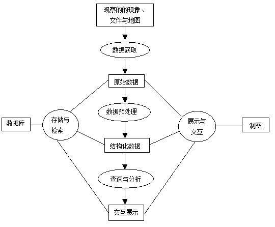
** Six components of spatial information processing and analysis [Ding Yuemin]**
Spatial operations, such as map union, intersection, subtraction, buffer calculation, selection, etc.
Spatial statistical analysis is used to describe and analyze the relationship between spatial data, such as spatial autocorrelation analysis.
Spatial model, focusing on spatial phenomena, spatial structure, spatial relations and spatial location analysis, such as network analysis and water system generation, etc;
Spatial representation/visualization, focusing on the expression of spatial information;
Spatial database management, including spatial database design, spatial data structure, spatial data management and spatial query.
Spatial model base management, including model management for spatial decision support system, etc.
Data collection, monitoring and editing #
It is mainly used to obtain data to ensure the content and spatial integrity, numerical logic consistency and correctness of the data in the GIS database. Generally speaking, the construction of GIS database accounts for 70% or more of the investment in the construction of the whole system, and this proportion will not change significantly in the near future. Therefore, information sharing and automatic data input have become an important part of GIS research. At present, there are many methods and techniques that can be used for GIS data acquisition, some of which are only used in GIS, such as hand tracking digitizer. At present, automatic scanning input and remote sensing data integration are the most concerned. The application and improvement of scanning technology and the realization of automatic editing and processing of scanning data are still the main technical keys of GIS data acquisition research.
Data processing #
The preliminary data processing mainly includes data formatting, transformation and generalization. Data formatting refers to the transformation between different data structures, which is time-consuming, error-prone and requires a large amount of calculation, which should be avoided as much as possible; data conversion includes data format transformation, changes in data scale and so on. In the conversion mode of data format, the conversion from vector to grid is faster and simpler than its inverse operation. The transformation of data scale involves data scale scaling, translation, rotation and other aspects, of which the most important is projection transformation; cartographic generalization includes data smoothing, feature aggregation and so on. At present, the function of data generalization provided by GIS is very weak, and there is still a big gap with the requirements of map synthesis, so it needs further development.
Data storage and organization #
This is a key step in the establishment of GIS database, which involves the organization of spatial data and attribute data. Raster model, vector model or raster / vector hybrid model are commonly used methods of spatial data organization. To a certain extent, the choice of spatial data structure determines the function of data and analysis that the system can perform; in the organization and management of geographic data, the most important thing is how to integrate spatial data and attribute data. At present, most systems store the two separately and connect them through common items (generally defined as figure identification codes). The disadvantage of this kind of organization is that the definition of the data is separated from the data operation, so it can not effectively record the change attributes of the ground objects in the time domain.
Spatial query and analysis #
Spatial query is the most basic analysis function that GIS and many other automatic geographic data processing systems should have. Spatial analysis is not only the core function of GIS, but also the fundamental difference between GIS and other computer systems. model analysis is to analyze and solve space-related problems in the real world with the support of GIS. It is an important symbol of deepening the application of GIS. The spatial analysis of GIS can be divided into three different levels. It includes retrieving spatial objects and their attributes from spatial locations and retrieving spatial objects from attribute condition sets. “Spatial index” is the key technology of spatial retrieval, how to effectively retrieve the required information from large GIS databases will affect the analytical ability of GIS; on the other hand, the graphic representation of spatial objects is also an important part of spatial retrieval. Spatial topological overlay integrates the attributes of input features and spatially connects them. This process is, in essence, a spatial Boolean operation. Regarding spatial model analysis, much of the current research focuses on combining GIS with spatial modeling. The work can be divided into three types: The first is the spatial model analysis of the external geographic information system, which regards the geographic information system as a general spatial database, while the spatial model analysis function relies on other software. The second category is the spatial model analysis within GIS, which attempts to use GIS software to provide spatial analysis modules and develop macro languages suitable for problem-solving models. This method is generally based on the complexity and diversity of spatial analysis and is easy to understand and apply, but the function of spatial analysis provided by GIS software is very limited. This closely integrated spatial model analysis method is rarely used in the design of practical geographic information systems. The third type is the hybrid spatial model analysis, which aims to make the best use of the functions provided by GIS and give full play to the initiative of users of GIS.Spatial retrieval #
Spatial topology overlay analysis #
Spatial model analysis #
Maps and Interactive Display #
GIS provides users with many tools for the representation of geographic data, which can be in the form of computer screen display or hard-copy maps such as reports, tables, maps and so on. special emphasis should be placed on the map output function of GIS. A good geographic information system should be able to provide a good and interactive mapping environment for GIS users to design and produce high-quality maps.