Since this projection was formulated by German mathematician, physicist and astronomer Gauss in the 1920s, and then supplemented by German geodesist Kruger in 1912, it is called Gauss-Kruger projection.
Gaussian-Krüger projection is called the Transverse Mercator projection in the United States and the United States. The global horizontal axis Mercator projection (UTM) used by the United States to compile military maps and Earth resource satellite images around the world is a variant of the Transverse Mercator projection. The central meridian length ratio of the Goskerl projection is equal to 1, and the UTM projection specifies a central warp length ratio of 0.9996. The maximum length distortion in the 6 degree band does not exceed 0.04%.
The central longitude and equator of Gauss Kruger’s projection are perpendicular to each other. The other longitudes are concave and symmetrical to the central longitude. The other latitudes are bipolar curves with the equator as symmetrical axis, and the longitude and latitude intersect at right angles. On this projection, the angle is not distorted. The length ratio of the central meridian is equal to 1, and there is no length distortion. The length ratio of the other meridians is greater than 1, the larger the deformation ispositive,the farther away from the central meridian. The maximum deformation is at the junction of the edge meridian and the equator. The further the area deformation is also from the central meridian, the larger the deformation. In order to ensure the accuracy of the map, the zonal projection method is adopted, which limits the eastern and Western boundaries of the projection scope so that the distortion of the map does not exceed a certain limit. By combining many bands, it can become the projection of the whole region (Fig. 4-12). The distortion characteristics of Gauss-Kruger projection are as follows: on the same longitude, the length deformation increases with the decrease of latitude, and reaches the maximum at the equator; on the same latitude, the length deformation increases with the increase of longitude difference, and the increase speed is faster. The maximum distortion of length is not more than 0.14% in the range of 6 degrees. Fig. 58 Gauss-Kruger Projection # 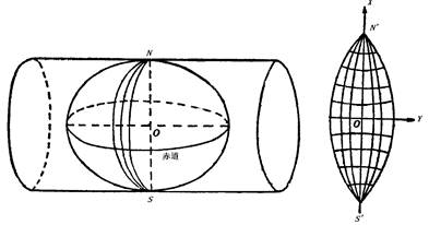
China has a scale map of 1:10000, 1:25,000, 1:50,000, 1:100, 1:25, and 1:500,000 scales, all using the Gosk Ruge projection. The 1:2.5 to 1:500,000 scale topographic map uses a difference of 6 degrees, and the 1:10000 scale topographic map uses a difference of 3 degrees.
The 6 degree band starts from the 0 degree meridian, and the difference is 6 from the west to the east. The global division is 60 bands, and the band numbers of each band are represented by natural ordinal numbers 1, 2, 3, … 60. That is, the east longitude 0-6 is the first zone, the central meridian is 3E, the east longitude 6-12 is the second zone, the central meridian is 9E, and the rest is analogous (Fig. 4-13).
The 3-degree zone, starting from the longitude of 1.30 degrees east longitude, is divided into 120 projection zones at intervals of 3 degrees. Figure 4-13 shows the relationship between the central longitude and the band number of the 6-degree band and the 3-degree band.
In the Goskeruig projection, the central meridian is defined as the X-axis and the equator is the Y-axis, and the intersection of the two axes is the coordinate origin. Fig. 59 Gaussian - Kruger projection zoning # 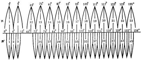
The value of X coordinate is positive to the north and negative to the south of the equator, while the value of Y coordinate is positive to the East and negative to the west of the central meridian. In the northern hemisphere of China, the X coordinates are all positive. Y coordinate is negative to the west of the central meridian, which is very inconvenient to use. In order to avoid the negative value of Y coordinates, the vertical axis of the coordinates of each belt is moved to the west by 500 kilometers, that is to say, all Y values are added by 500 kilometers.
Due to the use of the banding method, the projections of the bands are exactly the same, A coordinate value (x,y) has one in each projection band, and there are 60 identical coordinate values in the world. Exactly indicates the location of the point. Therefore, before the Y value, the band number is required, and such coordinates are called universal coordinates.
The Gauss Kruger projection zones are divided according to the same meridian difference. As long as the coordinates of each point in the zone are calculated, the other zones are applicable. The coordinate value of this projection is calculated in advance by the national surveying and mapping department according to the scale series of topographic maps and is used by the operation units.