Contents:
Agroclimatic Regionalization
Project Background and Requirements
Since the 1980s, China’s agricultural production environment and climate environment have undergone tremendous changes, they are including:
The purpose of the third agroclimatic regionalization project proposed by China Meteorological Administration is to develop the software of Agriculture and Climate Distributed Information System (ACDIS) with new technologies, new methods and new data, to establish a monitoring system for the exploitation, utilization and protection of climate resources, and to carry out the resource level and three-dimensional, time and space in all directions. We should optimize the allocation of resources, give full play to regional climate advantages, seek benefits and avoid hazards, reduce the loss of climate disasters, and improve the overall benefits of resource development. It will provide decision-making basis for governments at all levels to guide agricultural production, adjust rural industrial structure, return farmland to forestry and prevent soil erosion, and serve local governments。
System Structure and Work Flow of Agricultural Climate Zoning Information System (ACDIS)
System structure
Agricultural Climate Regionalization Information System(ACDIS) is based on the GIS tool platform, a special tool for professional technicians is established, which is suitable for monitoring and evaluation of agroclimatic resources, management and analysis of climatic resources, calculation and spatial query of micro-grid climatic resources, production of products for provincial, prefectural and county level zoning, etc. The following functions are specifically realized:
Geographic basic information management: the basic geographical data of the district is managed, such as administrative divisions, water systems, traffic data, etc;
Small grid resource information management: the grid format information related to agroclimatic zoning is managed, including various DEM data;
Small grid resource estimation and zoning product production;
Monitoring and evaluation of agroclimatic resources;
Demonstration of the results of agroclimatic regionalization.
System workflow
According to the demand of application of new technologies such as “3S” in agricultural climate regionalization, the basic process of agricultural climate regionalization was established (Fig. 14-2):
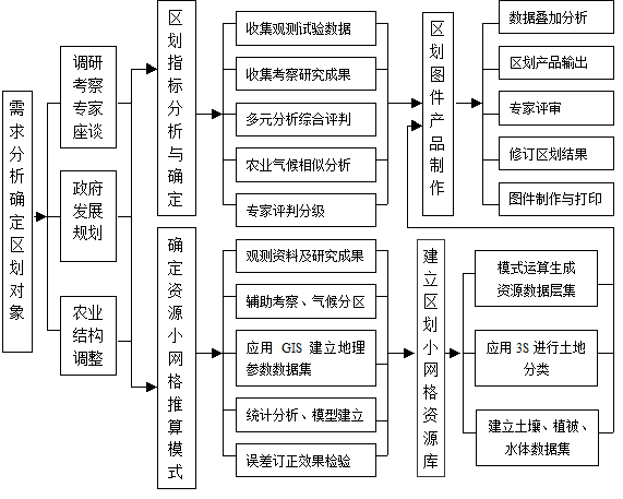
Fig. 133 Figure 14-2: Basic flow chart of agroclimatic regionalization
Application of “3S” in project
Spatial query and management of comprehensive factors in agroclimatic regionalization using GIS:ACDIS utilizes the basic functions provided by GIS tools to query and manage the climate resources input, processing and generation of other subsystems. The zoning products under different query conditions is generated as the thematic content of zoning, and then the logical query and management of the vector map are realized, raster map, DEM, annotation and attribute data of zoning products are based on geographical expression, as well as the comprehensive query and management of different maps and attribute data. It outputs the query results to the plotter or printer, or saves them in other formats。
Research on the model of small grid computing for climate resources by using GIS: The research on the small grid model of climate resources is a basic work of regionalization. On the basis of collecting climatic research results in mountainous areas and assisting with rainfall data of meteorological sentinels and hydrological stations, the geographic parameters (elevation, aspect and slope) of observation points can be quickly calculated and acquired through GIS platform. By means of statistical analysis, the province is divided into several climatic regions according to the statistical characteristic values and geographical characteristics of the elements. Statistical models for estimating climatic elements in each region are established respectively. Through verification and residual correction, the models are applied to the small grid calculation of climatic resources。
Application of GIS in Agricultural Climate Resources Analysis: It is to collect, manage and analyze climate resources by using GIS with spatial characteristics quantitatively, the idea, method and steps of GIS analysis of climate resources are established, including the establishment of digital elevation model, the establishment of GIS agricultural climate resources data, the establishment of spatial analysis model, the analysis and calculation of climate resources, the division of climate and quantitative analysis, etc。
Extract background information of agriculture to participate in regionalization calculation by using 3S: Agroclimatic regionalization is based on the requirements of climatic conditions and the geographical distribution characteristics of climatic resources in the process of crop growth and development. There are different types of land in the climatic plantable area of a certain crop. The different crops require different geographical environment. In order to guide agricultural production more effectively, non-meteorological factors were introduced into agricultural climate regionalization. The PH value of soil is often demanded in agricultural climate regionalization. According to the distribution of soil types, the distribution of soil PH value can be obtained. As a key index of regionalization, the regionalization has more practical significance. Soil classification map is used as a data layer in the operation of climatic resource data layer set by GIS, and the result of regionalization including soil type information is obtained。
Establishing an information service system integrating regionalization, resource dynamic monitoring and high-yield cultivation techniques by using GIS: A Web-based spatial allocation information system of climate resources for Two-line Hybrid Rice Seed production is developed by using GIS tools, which is sensitive to climate conditions. The regionalization will serve the selection of crop production bases, meteorological services for critical growth periods, and technical guidance for agricultural production。