Memcached is a free open source, high-performance, distributed in-memory object caching system.
Memcached is a software developed by Brad Fitzpatric of Danga Interactive, asubsidiary of LiveJournal. Now it has become an important factor to improvethe scalability of Web applications in many services, such as mixi, hatena,Facebook, Vox, LiveJournal and so on.
Memcached is a memory-based
key-value
storage, which is used to store arbitrary data (strings, objects) of small pieces. This data can be the result of database calls, API calls, or page rendering.
Memcached is simple and powerful. Its concise design facilitates rapid development, reduces the difficulty of development, and solves many problemsof large amount of data cache. Its API is compatible with most popular development languages.
In essence, it is a concise
key-value
storage system.
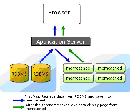
The purpose of general use is to reduce the number of database visits by caching database query results, so as to improve the speed and scalability of dynamic Web applications.
Memcached official website: https://memcached.org/ . The protocol is simple Based on Built-in memory storage Many languages have implemented connections Perl PHP Python Ruby C# C / C + Lua Wait LiveJournal Wikipedia Flickr Bebo Twitter Typepad Yellowbot Youtube WordPress.com Craigslist Mixi 1.1.1. Features 
memcached
as a high-speed distributed cache server, it has the followingcharacteristics.
libevent
event handling based on
memcached
distributed that do not communicate with each other 1.1.2. Supported languages 
memcached
the client side is mainly Perl and PHP. only
memcached
listed on the website are: 1.1.3. Memcached user 