By default, the tag content is generally displayed in the
input
at the top of the input box:

Using floating tags, you can use the
input
insert a label in the input box and click
input
float them to the top when you enter the boxes
Note: Text box We can use a floating tag on the selection menu, which will always be displayed in the upper-left corner of the selection menu and will not have aclick-and-float effect: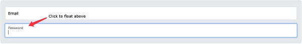
7.36.1. Bootstrap instance 
<div class="form-floating mb-3 mt-3">
  <input type="text" class="form-control" id="email" placeholder="Enter email" name="email">
  <label for="email">Email</label>
</div>

<div class="form-floating mt-3 mb-3">
  <input type="text" class="form-control" id="pwd" placeholder="Enter password" name="pswd">
  <label for="pwd">Password</label>
</div>
<label>
the element must be in the
<input>
element, and each
<input>
elements are needed
placeholder
property.Text box 
textarea
you can also have a floating effect: 7.36.2. Bootstrap instance 
<div class="form-floating">
  <textarea class="form-control" id="comment" name="text" placeholder="Comment goes here"></textarea>
  <label for="comment">Comments</label>
</div>
Selection box 
7.36.3. Bootstrap instance 
<div class="form-floating">
  <select class="form-select" id="sel1" name="sellist">
    <option>1</option>
    <option>2</option>
    <option>3</option>
    <option>4</option>
  </select>
  <label for="sel1" class="form-label">Select list (select one):</label>
</div>