Differences between WebGIS and desktop GIS, mobile GIS and 3D GIS
What is WebGIS?
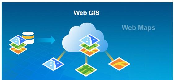
WebGIS is a special geographic information system based on Web technology. WebGIS publishes and applies geospatial data through the Internet to realize the sharing and interoperability of spatial data, such as online query and business processing of GIS information.
WebGIS can adopt multi-host and multi-database for distributed deployment. It is a browser/server (B/S) structure. The server provides information and services to the client. The browser (client) has the function of obtaining various spatial information and applications.
WebGIS is the product of IT technology applied to GIS development. GIS has been expanded through Web functions and really become a tool for the public. From any node of the Web, Internet users can browse the spatial data in the WebGIS site, make thematic maps, and conduct various spatial retrieval and spatial analysis, so that GIS can enter thousands of households.
WebGIS is currently the most widely distributed and widely used GIS application, and the map application based on WebGIS has become a part of people's network life. At present, GIS development and application are also increasingly inclined to the Web side.
What is desktop GIS?
Desktop GIS is a powerful vectorization data processing platform that does not take special geographic information engineering as the target, but through the map interface. Generally, it refers to desktop GIS software.
Desktop GIS software is easy to operate, suitable for batch processing, attribute operation, analysis operation, etc., and suitable for information systems that query various information and integrate common geographic analysis technologies.
Desktop GIS is a symbol of the popularization and socialization of GIS, and its technical level also reflects the application level and popularization degree of GIS technology. Desktop GIS can realize the integration of two and three dimensions, and has powerful capabilities of data management and editing, data mapping and visualization, spatial analysis and image processing, and three-dimensional visualization and analysis.
What is mobile GIS?
Mobile GIS, or Mobile GIS, refers to the GIS technology applied to the mobile end. Compared with traditional GIS, the architecture of mobile GIS is slightly more complex because it requires real-time transmission of spatial information to the server.
The architecture of mobile GIS is mainly composed of three parts: client part, server part and data source part, which are respectively carried in the presentation layer, middle layer and data layer.
The presentation layer is the bearing layer of the client, which directly deals with users and is the window to provide GIS services to users. This layer supports various terminals, including mobile phones, PDAs, vehicle-mounted terminals, and PCs, providing update support for mobile GIS. The data layer is the distribution center of all kinds of data in mobile GIS, which ensures the foundation and support for the realization of GIS functions.
The middle layer is the core part of mobile GIS, and the servers of the system are concentrated in this layer, which is mainly responsible for transmitting and processing spatial data information, executing the functions of mobile GIS, etc. It includes Internet, Web Server, Map Server and other components. Mobile GIS has five main characteristics: mobility, location dependence, real-time, diversified terminals, and diversified information carriers.
Mobility. Mobile GIS is running on various mobile terminals. Through wireless communication technology and server interaction, it can provide spatial information services anytime and anywhere.
Client diversity. The client of mobile GIS refers to the mobile terminal equipment used outdoors. It can be a mainstream microcomputer with powerful computing power, a variety of mobile computing terminals with small screen and limited functions, such as PDA, mobile phone, and even a dedicated GIS embedded device. This determines that mobile GIS should be an open and scalable platform.
Real-time service. The biggest feature of mobile GIS is that, with the support of various navigation and positioning devices, the collected relevant information can be processed and released to users in a timely manner without restriction in the process of moving.
Data resources are scattered and diverse. The extension of mobile GIS operation platform to wireless network further broadens its application field. Because the location of mobile users is constantly changing, and the information required by mobile users is also diverse, which requires the system to support different transmission methods, any single data source cannot meet all mobile data requests.
The diversity of information carriers. Compared with traditional GIS, mobile terminal users have more interactive means with servers and other users, including location services, video, voice, image, graphics, text, etc.
Application field of mobile GIS
Mobile GIS has many applications, mainly including the following:
1.Routing
Routing is the most popular implementation method of mobile terminal based on GIS. Mobile users can indicate the starting point, destination and passing position to the mapping system.
2.Query
According to the location information given by the user, search the map database to query the location required by the user. Users can check the information of hotels, banks and other public facilities within a certain radius. If the mobile terminal is equipped with GPS, users can obtain their own position from GPS.
3.Real-time traffic report
The wireless camera installed on the important crossing road can record the traffic situation in real time and transmit it to the network server. When the driver is driving on a road, if he wants to change the route, he can choose the route from the mobile terminal according to the real-time traffic conditions obtained. The displayed image can be refreshed regularly or by video.
4.Personal mobile location information service
At present, LBS is one of the most widely used mobile GIS services. Through the integration with GPS, the mobile terminal can locate the user's location, search the nearest restaurant, passenger, bookstore, shopping mall and other information that the user urgently wants to know according to the user's location, and display it in a graphical way.
5.Personal safety and emergency rescue
When the user's personal safety is threatened, the current location information can be transmitted to 110, 120 and other alarm or rescue centers to realize real-time rescue services.
6.Logistics distribution
The process of logistics distribution is the process of spatial location transfer of physical objects. In the process of logistics distribution, it may involve the processing links of goods transportation, storage, loading and unloading, delivery, etc. The application of embedded GIS can provide spatial location for logistics distribution, optimize the selection of warehouse location and distribution routes, monitor the running track of vehicles, and pursue the maximum utilization of distribution resources.
7.Outdoor information collection and transmission
Collect and transmit various spatial and attribute information in the field, synchronize the information to the remote server through wireless network, or store the information locally first, and then conduct wired synchronization.
Differences
<center> <table height="200" border="1" cellpadding="0" cellspacing="0"> <tbody> <td><div align="center"><strong></strong></div></td> <td><div align="center"><strong>WebGIS</strong></div></td> <td><div align="center"><strong>Desktop GIS (professional title)</strong></div></td> <td><div align="center"><strong>Mobile GIS</strong></div></td> <td><div align="center"><strong>3D GIS</strong></div></td> </tr> <tr> <td><div align="center" >Characteristics</div></td> <td><div align="center" >The most widely used, primitive and basic GIS application technology. GIS development and application tend to WebGIS.</div></td> <td><div align="center" >Generally refers to desktop GIS software, which is suitable for batch processing, attribute operation and analysis operation.</div></td> <td><div align="center" >Different from traditional GIS technology, mobile GIS.</div></td> <td><div align="center" >3D GIS is different from two-dimensional GIS, and belongs to a form of presentation.</div></td> </tr> <tr> <td><div align="center" >Application</div></td> <td><div align="center" >Simple operation, low development and management cost, and convenient information sharing.</div></td> <td><div align="center" >It has the functions of data management and editing, spatial analysis and image processing, 3D visualization, cartographic visualization and analysis, etc.</div></td> <td><div align="center" >It has the characteristics of mobility, location dependence, real-time, diversified terminals, diversified information carriers, etc.</div></td> <td><div align="center" >3D GIS display is more intuitive and multi-dimensional spatial analysis function is more powerful.</div></td> </tr> </table> </body> <html> </center>