What are the advantages of 3D GIS compared to 2D
The Role of 3D GIS in Digital City Planning
Under the trend of integration of informatization and industrialization, the construction and application of digital cities have promoted the leapfrog development of society, especially in the context of the deep application and promotion of the Internet. Spatial comprehensive information management has become a cross integration point of various industries. Spatial information is applied to various levels of management and decision-making in urban planning functional departments, playing a crucial role in improving the efficiency of urban planning and engineering construction, as well as the level of planning, investment and other management work.
Urban planning includes urban planning management, urban underground pipeline management, urban surveying, urban environmental protection, urban cadastral management, water environment status, urban water supply and groundwater resource management, urban land management, power and telecommunications facility management, cable television information management, urban public security, urban transportation, tourism planning, and other fields. To build a good city, save social resources, and improve urban management efficiency, it is necessary to have a unified and scientific urban planning for urban management projects in various fields, and strictly follow the planning for construction. Digital urban planning is a systematic, scientific, policy oriented, and regional task. It is necessary to foresee and reasonably determine the development direction, scale, and layout of the city, make environmental predictions and evaluations, coordinate the relationships between various aspects in development, systematically arrange various constructions, and achieve a comprehensive effect of advanced technology, reasonable economy, coordinated "bone meat", and beautiful environment for the construction and development of the entire city.
3D GIS
3D Geographic Information System (3D-GIS) is a product of the development of urban geographic information systems towards dynamic, multidimensional, and networked directions. It is a combination of virtual reality technology and geographic information systems. Virtual reality (VR) technology is the use of computer technology to generate a realistic virtual environment with various senses such as sight, hearing, and touch. Users interact with entities in the virtual environment through various interactive devices to generate immersive interactive visual simulation and information exchange, which is an advanced digital human-machine interface technology. We use Geographic Information Systems (GIS) to collect, store, manage, analyze, and describe various types of spatial geographic data, and assign this information attribute to the construction of 3D models based on VR technology, enabling them to analyze and process specific goals, achieving auxiliary decision-making for urban planning.
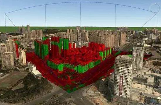
3D GIS has rich functions, providing analysis functions such as spatial data, attribute information search, distance measurement, area measurement, excavation and filling analysis, water flooding analysis, shortest path analysis, profile analysis, sunlight analysis, visibility analysis, height control analysis, and comparison and selection of fixed point observation plans. It also provides roaming functions such as path sightseeing, vehicle travel, pedestrian travel, and flight mode, and supports the import of externally produced planning and design plans.
The Importance of 3D Surveying and Mapping (3D GIS) in Digital City Planning
The current surveying and mapping system is based on the 2+1 dimensional theory, which determines the plane position of the target in two dimensions and the elevation of the target in one dimension. After hundreds of years of development, 2+1 dimensional surveying and mapping technology has reached a relatively complete level; But with the development of society and technology, the results of 2+1 dimensional surveying and mapping can no longer fully meet the needs of social development and economic construction. A 2+1 dimensional map is actually a view of the ground from the air, and most of the time people live on the ground. When walking on the street, they see the surrounding three-dimensional scenery, which cannot be expressed on a 2+1 dimensional map. The attributes of digital city planning require a reliable foundation for understanding the city, and urban 3D surveying can provide the necessary data for digital city planning in several important aspects such as terrain, cadastral information, and real estate.
3D GIS, like 2D GIS, requires the most basic spatial data processing functions, such as data acquisition, data organization, data manipulation, data analysis, and data representation. Compared to 2D GIS, 3D GIS has the following advantages.
The display of spatial information is more intuitive. Since people understood how to understand and transform the world through spatial information, spatial information mainly exists in a graphical form. However, using a two-dimensional graphical interface to display spatial information is very abstract and only professionals can understand how to use it. Compared with 2D GIS, 3D GIS provides a richer and more realistic platform for the display of spatial information, enabling people to visualize and visualize the abstract and difficult spatial information visualization. People can understand it by combining their own relevant experience, so as to make accurate and rapid judgments. Undoubtedly, 3D GIS has unique advantages in visualization.
Multidimensional spatial analysis is more powerful. The analysis process of spatial information is often complex, dynamic and abstract. In front of a large number of spatial information with complex relationships, the spatial analysis function of 2D GIS often has certain limitations, such as submergence analysis, geological analysis, sunshine analysis, spatial diffusion analysis, visibility analysis and other advanced spatial analysis functions, which cannot be realized by 2D GIS. Since 3D data itself can be reduced to 2D, 3D GIS can naturally contain the spatial analysis function of 2D GIS. The powerful multi-dimensional spatial analysis function of 3D GIS is not only a leap of GIS spatial analysis function, but also fully reflects the characteristics and advantages of GIS to a greater extent. It provides a powerful 3D spatial analysis function for digital city planning.
Digital city 3D surveying and mapping is a technology that measures the spatial 3D coordinates of targets, determines the geometric shape, spatial position, and spatial posture of 3D targets, and reconstructs the targets in 3D and reproduces them as realistically as possible on a computer. The content of urban 3D surveying and mapping includes 3D terrain, 3D real estate, 3D scenes, 3D infrastructure, 3D greening, etc.
The demand for three-dimensional surveying and mapping is urgent. Urban planning, especially the planning of old city renovation, has begun three-dimensional planning. Serving urban planning and engineering planning is an important application field of engineering surveying, and three-dimensional surveying and mapping should keep up in a timely manner. Now 3D engineering design has emerged, and 3D CAD software has become popular. Engineering design should be based on reproducing the shape diagram, so the current situation diagram should also be a 3D diagram, which also requires us to achieve three-dimensional surveying and mapping. On the basis of 3D surveying, 3D geographic information systems can better serve digital urban planning.