Making GIS 3D visualization simple - geographic coordinate system
Preface
Geographic location, also known as coordinates, is the soul of GIS. When accidents such as weather forecasts, rocket launches, earthquakes, volcanoes occur, news media will say what happened at XX degrees east longitude and YY degrees north latitude. Additionally, Baidu's map navigation, positioning, and so on all require the use of coordinate systems, as without accurate location information, the positional relationships of land objects cannot be expressed, There's no way to talk about map query and analysis, and so on.
Coordinate systems can be divided into geographic coordinate systems and projection coordinate systems
Today, we will use coordinate conversion in Cesium as a guide to popularize the knowledge of coordinate system to non professional partners. It is more conceptual, so we don't need to remember all of it, just understand the concept. Let's start with geographical coordinate system.
The geographical coordinate system is also called the Geographic Coordinate System (GCS for short), which is a positioning reference system generated by the space elements on the earth's surface.
Understanding the Earth
Historical evolution
We definitely need a reference object to know where a certain place or object is located, and for modern living on Earth, we know that in order to achieve precise global positioning, the reference object can only be the Earth, because we have a clear understanding of the shape and size of the Earth and the relationship between humans and the Earth.
However, in ancient times, people only saw a small area of their living area due to their small range of activities, which led to various theories about the sky and the place based solely on intuition.
For example, as early as the Zhou Dynasty more than two thousand years ago in China, there was a saying that the sky was as round as Zhang Gai and the place was like a chess game.
The ancient Egyptians knew that the sky was like a dome shaped ceiling, and the ground was like a square box.
Russians believe that the earth is like a shield, carried by three giant whales on their backs, drifting in the vast ocean.
Indians also have a similar legend in Russia, but they believe that carrying this land is not a giant whale, but three elephants standing on the back of a turtle, and a movement of the elephant can cause an earthquake.
Later, the ancient Greek scientist Aristotle proposed that the earth was spherical, and it was not until Magellan successfully circled the earth in 1519-1521 that the name Earth officially came into being.
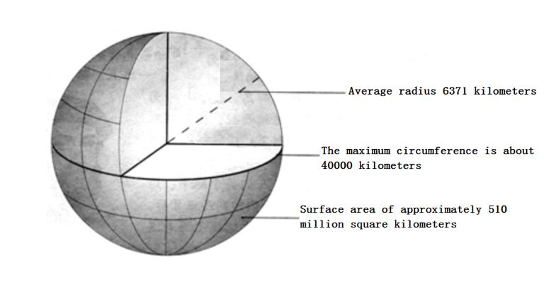
With the continuous progress of measurement technology, especially the use of artificial Earth satellites, we have a clear understanding of the Earth. The Earth is not a regular sphere, but an irregular sphere with slightly flat poles and slightly bulging equator, which can become an ellipsoid. The average radius of the Earth is 6371 kilometers, and the polar radius is 6356 kilometers, with a difference of 21 kilometers between the two. The maximum circumference is what we call the equator, which is about 40000 kilometers, The surface area is approximately 510 million square kilometers, as shown in the following figure.
Longitude, latitude, and radian
Geographic coordinate system is defined by longitude and latitude, so some people may not know longitude and latitude, so, here we also introduce longitude and latitude.
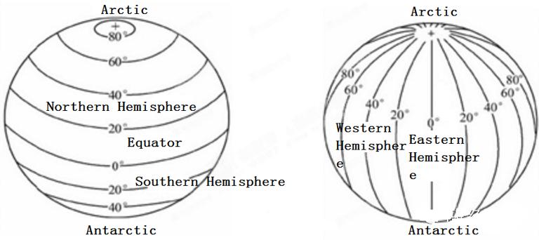
Longitude measures angles eastward or westward from the prime meridian, positive in the eastern hemisphere and negative in the western hemisphere, while latitude measures angles northward or southward from the equatorial plane. The equatorial north is positive, and the equatorial south is negative.
The prime meridian refers to the meridian that connects the north and south poles on Earth, with many names such as zero meridian, prime meridian, and zero meridian. The equator is the longest circumference of the trajectory generated by the Earth's rotation on the surface, dividing the northern and southern hemispheres.
The prime meridian and the equator are the baselines of the geographical coordinate system. The tangency of the two can be understood as the x/y coordinate axis, so the longitude is equal to the x value, and the latitude is equal to the y value, as shown in the following figure.
We can use the units of longitude and latitude in degrees, minutes, seconds (DMS), decimal degrees (DD), or radians (rad) that we may use in transformation.
In the degree minute second representation, 1 degree equals 60 minutes, and 1 minute equals 60 seconds (1 °=60 ′ 1 ′=60 ″). For example, if the latitude and longitude are 45 ° 52 ′ 30 ″, we can convert them to decimal to represent 45.875 ° (45+52/60+30/3600). In addition to the commonly used radians, we can remember two values:
1rad = 57.2958°
1°  = 0.01745rad
Geoid
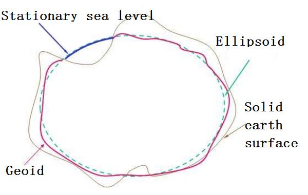
The surface of the Earth is rugged with mountains and depressions, so when we want to use mathematical rules to describe it, we must find a relatively regular mathematical surface.
As we all know, the earth can also be called a water globe, because most of it is an ocean, so people assume that the sea water is in a completely static equilibrium state, then from the sea level to the lower part of all continents, and a continuous and closed surface orthogonal to the direction of the earth's gravity everywhere is the geoid, as shown in the following figure.
Earth ellipsoid & ellipsoid surface
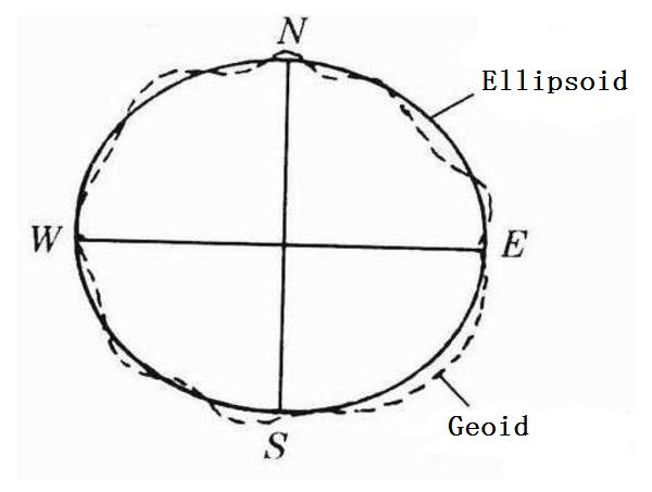
We said above that the geoid ignores the relatively regular unevenness on the ground, but because of the uneven distribution of materials in the earth, the geoid is still uneven. Although it is very close to a regular ellipsoid, it is not completely regular, and there is no way to express it mathematically.
We know that an ellipsoid can be generated by rotating an ellipse around the minor axis, so in order to quantitatively describe the shape of the earth without being affected by fluctuations, the most ideal rotating ellipsoid that conforms to the geoid is called the earth ellipsoid, also called the reference ellipsoid, and the ellipsoid surface that can be expressed by mathematical equations is selected as the projection datum plane, which is called the reference ellipsoid, referred to as the ellipsoid for short, refer to the following figure:
Geodetic Datum
We mentioned the concepts of geoid, ellipsoid, ellipsoid and so on. Next, let's look at the geoid. In brief, we compare the earth to a potato, because its surface is pitted, so the reference ellipsoid we mentioned above can be represented by duck eggs. Because it is relatively regular, we can choose a azimuth perspective to place the duck eggs on the potato, Rotate or zoom in and out the duck egg to fit the potato surface in this orientation as closely as possible. After adjusting appropriately, the duck egg surface in this orientation perspective is the geodetic reference plane.
Since we can rotate the potato freely to change the orientation, the duck egg (reference ellipsoid, the reason is that their reference planes are different, as shown in the following figure.
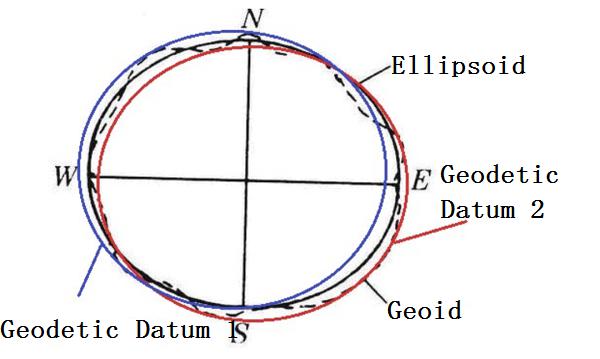
The Beijing 54 coordinate system and Xi'an 80 coordinate system, which we often hear, actually refer to the two geodetic datums in China.
Different countries have different positions in the potato (earth), and the duck egg (reference ellipsoid) produced by rotating to enlarge or shrink is also different, so many reference ellipsoid have been produced. China has established the Beijing 54 coordinate system with the reference to the former Soviet Union since 1953, using the Krassovsky ellipsoid. Later, in 1978, a new geodetic coordinate system Xi'an 80 coordinate system was established using the 1975 Earth ellipsoid (IAG75) recommended by the International Association of Geodesy.
Reference center coordinate system
The measurement of a sphere must be centered. As we said above, the duck egg is the reference ellipsoid. The center of the earth is not easy to determine, but the reference ellipsoid is regular. Then the geodetic coordinate system with the geometric center of the reference ellipsoid as the origin is the reference center coordinate system, and this reference center refers to the center of the reference ellipsoid, which we count as the origin O.
The reference center coordinate system usually refers to the reference center space Cartesian coordinate system system (with x, y, z as coordinate elements), and the reference center geodetic coordinate system (with B, L, H as its coordinate elements).
The reference center coordinate system is an O-XYZ coordinate system established within a reference ellipsoid. The origin O is the geometric center of the reference ellipsoid, and the X-axis coincides with the intersection line of the equatorial plane and the primary meridian plane, with an easterly direction being positive. The Z-axis coincides with the short axis of the rotating ellipsoid, and the north-facing direction is positive. The Y-axis is perpendicular to the XZ plane, forming a right-handed system, as shown in the following figure.
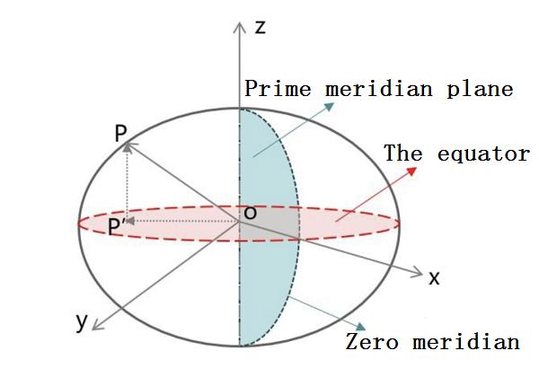
In surveying, in order to process observation results and calculate the coordinates of the ground control network, it is usually necessary to select a reference ellipsoid as the basic reference plane, select a reference point as the starting point of geodesy (this point is the geodetic origin), and use astronomical measurements of the geodetic origin to determine the position and direction of the reference ellipsoid inside the Earth.
Geocentric coordinate system
Before the 1950s, a country or a region established its own local geodetic coordinate system according to the radian measurement method under the condition of making the selected reference ellipsoid best fit the geoid of its region.
Due to the fact that at that time, apart from sparse gravity measurements in the ocean, geodetic work could only be carried out on various continents, and there was almost no connection between the local geodetic coordinate systems of each continent. However, at the level of scientific development at that time, the local geodetic coordinate systems could basically meet the requirements of geodetic surveying and mapping work in various countries.
But later, in order to study the overall shape of the figure of the Earth, its external gravity field and geodynamic phenomena, especially after the emergence of artificial earth satellites and long-range ballistic weapons in the late 1950s, in order to describe their positions and movements in space, and to express the positions of their ground launch stations and tracking stations, geocentric coordinate systems must be used. Therefore, Establishing the global geocentric coordinate system (also known as the world coordinate system) has become an urgent task faced by geodesy, and later established the Earth's center of mass (i.e. the world's unified only central point of the Earth).
Under this background, the space Cartesian coordinate system system established with the earth's center of mass as the origin, or the geodetic coordinate system established with the earth's ellipsoid whose center of mass coincides with the earth's center of mass as the datum plane was born.
Geodetic coordinate systems with the Earth's centroid as the origin are generally divided into geocentric space Cartesian coordinate system systems (with x, y, z as its coordinate elements) and geocentric geodetic coordinate systems (with B, L, H as its coordinate elements).
The geocentric coordinate system is an O-XYZ coordinate system established within the Earth's body, with the origin O located at the center of mass of the Earth. It is represented by three mutually perpendicular axes, namely X, Y, and Z. The X axis coincides with the intersection line of the meridional plane and the equatorial plane, with the east axis being positive, the Z axis coinciding with the Earth's rotation axis, the north axis being positive, and the Y axis perpendicular to the XZ plane forming a right-handed system, similar to the above reference map.
At this point, I believe you have gained a new understanding of our Earth. Next, we will introduce several commonly used coordinate systems.
Common coordinate systems
Here we briefly introduce four common coordinate systems, namely Beijing 54 and Xi'an 80, which were used in early China, CGCS2000, which is the mainstream in China, and WGS84, which is commonly used in the world.
Beijing 54
After the establishment of the People's Republic of China, China adopted the Krasovsky ellipsoid parameters of the former Soviet Union (which means it is a reference center coordinate system) and conducted joint measurements with the former Soviet Union's 1942 coordinate system. Through calculation, China established its geodetic coordinate system, named the 1954 Beijing coordinate system, abbreviated as the Beijing 54 coordinate system.
The 1954 Beijing coordinate system can be considered an extension of the former Soviet Union's 1942 coordinate system, as its origin is not in Beijing but in Pulkovo, the former Soviet Union.
At the beginning of the founding of the People's Republic of China, Beijing 54 introduced the geographical coordinate system of the Soviet Union to China when the technical conditions were not high, and the geodetic origin was not in China, so Beijing 54 had a large deviation in China and had been gradually abandoned.
Xi'an 80
In April 1978, the National Astronomical Geodetic Network Adjustment Conference was held in Xi'an to determine repositioning and establish a new coordinate system in China. As a result, the 1980 National Geodetic Coordinate System was established, which adopted the basic parameters of the Earth's ellipsoid as the recommended data (also known as the reference coordinate system) at the 16th Congress of the International Union of Geodesy and Geophysics in 1975.
The geodetic origin of this coordinate system is located in Yongle Town, Jingyang County, Shaanxi Province, central China, approximately 60 kilometers northwest of Xi'an City. Therefore, it is called the 1980 Xi'an coordinate system, also known as the Xi'an 80 coordinate system.
Its reference plane adopts the average sea level of the Yellow Sea determined by the Qingdao Dagang Tide Gauge Station from 1952 to 1979 (i.e. the 1985 National Elevation Datum), which has gradually been abandoned.
Xi'an 80 and Beijing 54
The Xi'an 80 coordinate system and the Beijing 54 coordinate system are actually a type of transformation of ellipsoidal parameters. The transformation within the same ellipsoid is rigorous, while the transformation between different ellipsoids is not rigorous. Therefore, there is no set of transformation parameters that can be used nationwide, and they will be different in each place because they are two different ellipsoidal benchmarks.
Beijing 54 and Xi'an 80 are two different geodetic datums, and different reference ellipsoid. Therefore, under the two maps, the coordinates of the same point are different. No matter the coordinates of the third degree zone and the sixth degree zone, or the longitude and latitude coordinates are different. The same thing is that they have been gradually abandoned.
CGCS2000
From Beijing 54 to Xi'an 80, with the changing situation and the passage of time, the two local geodetic coordinate systems based on classical measurement technology can no longer adapt to the development of science and technology, especially space technology, and cannot meet the needs of China's economic and national defense construction. The update and replacement of China's geodetic coordinate system is an objective need for economic, national defense, social, and technological development.
The geocentric geodetic coordinate system with the Earth's center of mass as the origin is the basic global geodetic coordinate system in the 21st century space era. Therefore, the geocentric geodetic coordinate system based on space technology is a suitable choice for China's new generation of geodetic coordinate system.
CGCS2000 is the 2000 national geodetic coordinate system, which belongs to the geocentric geodetic coordinate system. This coordinate system is a geocentric geodetic coordinate system established through the combined adjustment of China's GPS continuous operation reference station, space geodetic control network, and astro geodetic network and space geodetic network. The 2000 (China) national geodetic coordinate system is based on the ITRF 97 reference frame, and the reference frame epoch is 2000.0. Its full name is China National 2000 Geographic Coordinate System, its English name is China Geodetic Coordinate System 2000.
The secondary coordinate system is the mainstream coordinate system in China at present. You may not know this coordinate system. Let's put it this way. China's GPS system - Beidou Navigation System and the national sky map all use this set of geographical coordinate system.
WGS84
WGS84 is a global geographic coordinate system used by GPS in the United States. OSM maps, Google Maps (foreign version), Landsat series satellite image maps, etc. all use this geographic coordinate system. Many map development APIs use WGS84 by default. Its full name is World Geodetic System 1984. Most of the data we exchange online are also WGS84, so currently, the most widely used coordinate system in the world may be WGS84.
Our country's Gaode, Baidu, and other maps also use WGS84, but they are all encrypted again on the basis of WGS84. In folk, they are called the Mars coordinate system and use the well-known GCJ02 encryption algorithm. It has errors with the real WGS84 coordinates, and this error value is not fixed. Usually, it is tens to hundreds of meters (Baidu Map is even more rugged, and it has been offset again on the basis of GCJ02, which is BD09, commonly known as the Baidu coordinate system).
CGCS2000 and WGS84
As mentioned above, both CGCS2000 and WGS84 coordinate systems are geocentric, so the definition of CGCS2000 is essentially the same as WGS84, using a reference ellipsoid that is very close.
However, due to the difference in flatness, the maximum latitude and height variation on the ellipsoid can reach 0.1mm, which can be ignored within the current measurement accuracy range. It can be said that the two are compatible to the cm level. However, if the coordinate accuracy of a point cannot reach the cm level, the coordinates of CGCS2000 and WGS84 are not considered compatible, and vice versa.
Summary of commonly used coordinate systems
Let's summarize these commonly used coordinate systems. As they are quite official in terms of introducing common sense, our summary should be more grounded.
At the beginning of the founding of the People's Republic of China, the Beijing 54 reference center coordinate system introduced the Soviet Union's geographical coordinate system to China when the technical conditions were poor. The geodetic origin was not in China, so there was a large deviation in China, and it has gradually been abandoned.
After the reform and opening up, Xi'an 80 reference center coordinate system is a geographical coordinate system that is suitable for domestic development and has been gradually abandoned to solve the problem of Beijing 54 deviation.
The CGCS2000, which is currently used in both the Beidou navigation system and Tianmapu, is the mainstream coordinate system in China.
WGS84 is a global geographic coordinate system originated from the United States and widely circulated in the world, the geocentric coordinate system.
<table width="99%" class="table table-bordered"> <tr class="origin-detail"> <th colspan="1"><div align="center" valign="middle"><strong>Coordinate System Name</strong></div></th> <th><div align="center" valign="middle"><strong>Beijing 54</strong></div></th> <th><div align="center" valign="middle"><strong>Xi'an 80</strong></div></th> <th><div align="center" valign="middle"><strong>WGS84</strong></div></th> <th><div align="center" valign="middle"><strong>CGCS2000</strong></div></th> </tr> <tr> <td>Reference ellipsoid</td> <td>Krasovsky_1940</td> <td>IAG75(The annotation in ArcGIS is Xian_ 1980 ellipsoid</td> <td>WGS_1984</td> <td>CGCS2000</td> </tr> <tr> <td>Ellipsoid radius b</td> <td>6353863.0187730473</td> <td>6356755.288158</td> <td>6356752.314245</td> <td>6356752.314140</td> </tr> <tr> <td>Ellipsoidal polar radius a</td> <td>6378245.000000</td> <td>6378140.000000</td> <td>6378137.000000</td> <td>6378137.000000</td> </tr> <tr> <td>Variability</td> <td>1/298.3</td> <td>1/298.25722101</td> <td>1/298.257223563</td> <td>1/298.257222101</td> </tr> <tr> <td>Reference level</td> <td>56the Huanghai Sea</td> <td>85the Huanghai Sea</td> <td>-</td> <td>85the Huanghai Sea</td> </tr> <tr> <td>Names in ArcGIS</td> <td>GCS_Beijing_1954</td> <td>GCS_Xian_1980</td> <td>GCS_WGS_1980</td> <td>GCS_China_Geodetic_Coordinate_System_2000</td> </tr> <tr> <td>WKID in ArcGIS</td> <td>4214</td> <td>4610</td> <td>4326</td> <td>4450 </tr> </table>
First of all, let me explain the WKID of ArcGIS. We should all know that ArcGIS, developed by the Environmental Systems Research Institute (ERSl) in the United States, is the leader in the GIS industry.
What is WKID? The full name of WKID is Well known ID, which means the ID of spatial reference. In brief, there are too many coordinate systems in the world. We compare each coordinate system to a person. Beijing 54, Xi'an 80, CGCS2000, WGS84, etc. are all short names. The full name is too long, and can be renamed. But the ID number is unique and unchanged. This ID number refers to WKID, which is used, converted Sharing and others play a crucial role, so remembering these commonly used IDs is beneficial.