Storage of map data in GIS
Maps can be stored in two ways in the computer:
- Vector data;
- Grating data.
Vector data model
The vector data structure uses the form of points, lines and surfaces to express the real world, with obvious positioning and implicit attributes.
Because vector data has the advantages of compact data structure, low redundancy, high expression accuracy, good graphics display quality, and is conducive to network and retrieval analysis. It has been widely used in GIS, especially in small area (large scale) mapping, making full use of its advantages of high accuracy.
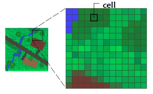
Grid data model
Grid data model is a data organization method that represents the distribution of spatial objects or phenomena in the form of two-dimensional matrix. Each matrix unit is called a grid unit (cell). Each data of the grid represents the attribute data of the figure or phenomenon. Therefore, the grid data has the characteristics of obvious attributes and implicit positioning.
Grid is very suitable for representing data that continuously changes along the surface. For example, elevation data is a common way to use surface maps. Of course, we can also use grids to express continuous changes in rainfall, temperature, density and population density.
Advantages of grid data structure:
The grid data structure is simpler, that is, it is composed of pixels to form a matrix structure, in which the pixel values represent coordinates, sometimes associated with the attribute table.
Advanced spatial and statistical analysis.
Can represent continuous surfaces and perform surface analysis.
Points, lines, faces and surfaces can be stored in the same way.
Fast overlay can also be performed for complex data sets.
However, grid data structure also has disadvantages. In these cases, vector structure storage is considered:
The pixel size of raster data sets has limitations and may bring spatial errors.
Grid data sets can be very large. Although the resolution will increase with the reduction of the grid pixel size, it will occupy more disk space and slow down the processing speed. For a given area, when the size of the grid pixel is changed to half the existing size, the storage space required will be increased by four times, depending on the data type and storage technology used.
When the data is reconstructed to the grid pixel boundary with fixed spacing, certain accuracy will also be lost.
If you want to do the spatial positioning of the figure, the vector data model is more suitable.