Abstract: Cultivated land is an important type of land resources. Land abandonment has a negative impact on national food security and inf...
Cultivated land is an important type of land resources. Land abandonment has a negative impact on national food security and infringes on public interests. China has a large population base and a huge demand for grain. The Chinese government has formulated a series of policies to increase cultivated land to ensure the balance between the utilization and supply of cultivated land. After the implementation of the agricultural land supplement policy, the imbalance between the use and supply of agricultural land has been gradually alleviated. However, it is noteworthy that the newly reclaimed farmland often has the disadvantages of large slope and barren land. These factors cause low crop yield, which can lead farmers to move out of the land, resulting in abandonment of cultivated land, thereby threatening the country's crop production security.
In the recognition of abandoned cultivated land, it is a traditional way for researchers to identify cultivated land use through field survey and statistical methods. The existing research points out that spectral characteristics can reflect crop growth information in remote sensing images, and their changes correspond to vegetation maturity. The spectral characteristics of different land types are obviously different, and the performance of spectral differences in remote sensing data can be used to distinguish cultivated land and non cultivated land. In recent years, NDVI has been gradually applied to the construction of remote sensing time series because of its good ability to distinguish vegetation characteristics, and the accuracy of reflecting vegetation phenology information. The mature practical application of NDVI series models based on Landsat and GF remote sensing data. Researchers use such models to obtain specific growth characteristics of crops and determine vegetation planting patterns in different regions.
NDVI time series model cannot completely overcome the influence of some data window periods and bad weather. In some mountainous areas in the south of China, remote sensing data are sometimes affected by humid weather, and it is difficult to establish a year-round time series. In this case, it is difficult to identify cultivated land using NDVI time series analysis method.
In this paper, based on the monsoon climate characteristic of precipitation in the growing season in the southern low mountain and hilly area, the identification method of distinguishing cultivated land by constructing NDVI time series is improved to reduce the difficulty of data collection, caused by climate factors and obtain more accurate identification results of abandoned new cultivated land.
1.Study area and materials
Study area
The study area is located in Xingning County, Meizhou City, Guangdong Province. Xingning is a county-level city under the jurisdiction of Guangdong Province, with an area of 2104.85 square kilometers. It is located in the hills of Guangdong and Guangxi. In 2019, the annual grain planting area in Xingning was 645400 mu, and the grain output was 294100 tons (Xingning Statistical Annual Report, http://www.xingning. gov.cn/xxgk/tjxx/content/post_1968697. html). The landscape of the study area consists of cultivated land, wild weeds (including abandoned farmland), forests, construction land, water bodies and bare land (including abandoned farmland).
Data acquisition
GF-1 satellite was launched on April 26, 2013. This study selects remote sensing image data from 2017 and 2018. With the cooperation of field research and high-resolution remote sensing images, based on the distribution of existing cultivated land in Xingning City on the remote sensing images from 2017 to 2018, use Arcgis10.2 to randomly select 300 sample points falling on the cultivated land, draw ROI according to the contour of cultivated land as training samples, and explore the time change rules and differences between cultivated land and non cultivated land NDVI. With the help of Xingning local government and the land consolidation laboratory of South China Agricultural University, the location information of all newly cultivated land in Xingning's ecological vulnerable areas during the implementation phase of the supplementary policy for newly cultivated land from 2009 to 2015 was collected. The study uses the cloud free (cloud amount less than 1%) GF-1 image (resolution of 2 meters) in the non production season (December), and production season (May) of 2018 to display sample patches. These rice fields were set as precision inspection units of the research results.
2.Research methods
In this study, decision tree method and NDVI time series curve month change characteristics were used to identify abandoned farmland. NDVI month analysis is added to the decision tree analysis to simplify the decision tree judgment process and improve the recognition accuracy. This study consists of three parts: constructing NDVI time series of several specific land types in the whole growth period of rice, analyzing curve variation difference and extreme value distribution, and determining threshold value as the division standard; Observe the NDVI difference between the production season and non production season of each time series curve, and determine the monthly difference of each defined land category; The decision tree method was used to identify whether the experimental farmland was abandoned.
Band data extraction of abandoned farmland
This study will start from the legal perspective of Chinese Mainland. When considering the timing factors, cultivated land abandonment refers to the situation that cultivated land has not been reclaimed for at least 2 years due to some special reasons.
The surface reflectance data obtained by NDVI preprocessing can more accurately reflect the real situation of the surface coverage, and is not affected by the atmosphere, sensors and other factors. These data sets can be used to calculate the seasonal difference between time series NDVI and NDVI. GF-1 satellite images with a resolution of 16m and Meizhou DEM30m images were extracted every month from 2017 to 2018 to build a farmland NDVI analysis database in the study area.
The remote sensor itself also has some factors that affect the spectral information, so data preprocessing (including image geometric correction, radiometric correction and atmospheric correction) is used to eliminate this effect.
NDVI monthly difference analysis
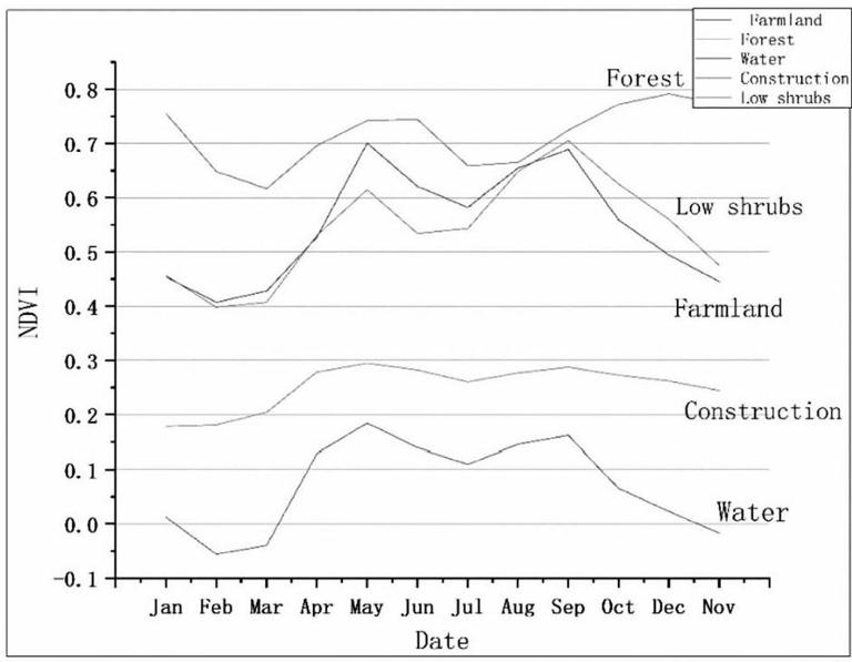
Previous studies have shown that the NDVI values of the same type of land in different months of the year are usually quite different (especially between the production season and other seasons). This paper analyzes the NDVI differences between productive and non productive seasons of different land types in Xingning County and classifies the land.
It can be seen from Figure 1 that the median value of NDVI data of cultivated land in June and September is above 0.7, showing the peak value of the curve. The data values for December and July are at the trough of the index curve. These values can be used to determine the threshold range of rice in Xingning region.
Construction of NDVI Threshold Decision Tree
Based on the recognition threshold of NDVI time series, the researchers conducted difference analysis on land NDVI data with 0.30 as the standard. For all sample points with a difference of more than 0.30, the characteristic curve matched by their values is considered as cultivated land. If all sample points do not meet the above two conditions and assumptions, they will be classified as potential "non cultivated land". The results can be considered as abandoned land only if they meet the existing assumptions for at least two consecutive years.
NDVI growth cycle series shows the spectral change characteristics of cultivated land month by month on the curve, and determines the maximum and minimum values. According to the time series constructed, the maximum value is in July and the minimum value is in December. At the same time, a series of NDVI time curves were constructed for other land classifications to distinguish cultivated land from other types of land. Finally, the decision tree mechanism is used to classify the sampling points and the received results.
Accuracy verification
In this study, ArcGIS 10.2 is used to randomly select points on high-resolution remote sensing images, and 305 test points are selected as test objects. Through field investigation and evidence collection, the accuracy of the research method is about 99.02%. In addition, the main purpose of this study is to explore whether the newly reclaimed farmland in Xingning City is abandoned. Therefore, when conducting accuracy verification, the researchers only discussed abandoned cultivation and planting, so chi square test was adopted. The final chi square coefficient is 0.898, with strong consistency and high acceptability.
3.Results
After treatment, the experimental results in 2017 and 2018 were obtained as the basis for whether the newly cultivated land was abandoned after the end of the reclamation period in 2009 and 2015. The new cultivated land in Xingning from 2009 to 2015 is divided into 7 parts according to the reclamation area, with a total of 305 experimental farmland (305 supplementary farmland). Through the above operations, ArcGIS is used to draw the monthly difference processing results of NDVI of cultivated land in the experimental area, and the spatial distribution of the main difference results in the study area is obtained. More than 95% of the new cultivated land in Xingning region was abandoned, most of which were weeds and low shrubs. From the overall analysis, the phenomenon of abandoned farmland is obvious in each part of the newly reclaimed farmland in the study (in this study, No.2015, No.2012 and No.2010 were not recorded in the data because there was no new planting farmland), and it is widely distributed in all the newly reclaimed farmland in the related studies.
4.Discussion
Features of NDVI time series curve method
In recent years, NDVI differential recognition model has been widely used in monitoring wind, dust storm, hail, mountain vegetation cover change and other fields. Based on remote sensing images from multiple sources and normalized vegetation index as selected indicators, NDVI difference analysis of remote sensing images of reference samples is processed and counted, and threshold is determined to distinguish the spectral characteristics of evergreen and deciduous. In this paper, the method is combined with the grain planting system in southern China, and applied to the identification of cultivated land in Lingnan mountain area. The advantage of monthly index difference recognition analysis is that it does not need to build the full growth cycle required by the time series curve, and can selectively skip the impact of sensors, weather and other factors on the time series curve. NDVI of grain crops such as rice and wheat is higher at heading stage, even reaching the highest value. At the same time, the index value of farmland will decline rapidly after harvest until the lowest point of the growth cycle. Using the indicators of these two periods, different models were established to distinguish the spatial distribution area of cultivated land and uncultivated land.
5.Conclusion
Based on the regional characteristics of mountainous areas in southern China, the comprehensive method combining NDVI time series curve and monthly vegetation index difference was used for testing and analysis. The study found that more than 90% of the newly reclaimed farmland in Xingning City was abandoned in October 2020 during the implementation of the occupation compensation balance policy in 2009 and 2015. At the same time, the study found that 73% of the new cultivated land was located in low mountains and hills with a slope of more than 6 °, and the planting conditions were relatively general. The results of this study will help the government and other decision-making institutions to more scientifically and rationally judge the current farmland occupation compensation balance policy in some mountainous areas, and ensure the quantity of newly cultivated land on the basis of ensuring the quality and sustainability of cultivated land.