Abstract: Satellite remote sensing is to detect and receive electromagnetic wave information radiated and reflected from target objects from...
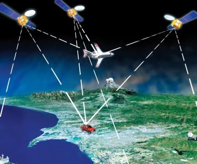
Satellite remote sensing is to detect and receive electromagnetic wave information radiated and reflected from target objects from high altitude through sensors, so as to identify the attributes of objects and their spatial distribution and other characteristics, and acquire data through the ground receiving station and process data through the remote sensing software platform. It is widely used in national defense, natural resources, transportation, meteorology, marine, environmental protection, emergency and other fields. From the perspective of satellite remote sensing industry chain, the upstream is for satellite manufacturing and satellite launch services, and the midstream is for remote sensing satellite operation and data reception and processing, the downstream is mainly satellite remote sensing industry applications and services.
Satellite remote sensing applications are developing towards precision, intelligence, convenience and popularity. Midstream data processing is the basis for the satellite application industry to achieve scale and industrialization. Aerospace Hongtu started in the middle of the industrial chain, participated in the design of 90% remote sensing satellite ground system, so as to expand to downstream applications, with certain advantages.
The market space has great potential but the pattern is scattered. The mutual penetration of upstream and downstream is expected to improve the industry concentration. The processing link in the middle reaches mainly depends on the localization logic. At present, the main participants in the field of basic software for remote sensing image processing in China include Harris of the United States (ENVI), American ESRI (ArcGIS) and Canadian PCI (PCIGeomatica), Google Earth Engine of the United States and PIE of China.
With the gradual implementation of the industrial policy to encourage the localization of satellite application software, import substitution is expected to be achieved in the field of domestic remote sensing image processing basic software. The domestic remote sensing image processing basic software field is expected to realize import substitution. In the downstream application field, the main participants in the domestic remote sensing application field can be divided into four types:
-
Aerospace World Vision, Aerospace Titan and other subordinate state-owned enterprises of aerospace science and technology;
-
Scientific research institutes and incubated enterprises of colleges and universities such as Zhongke Xingtu and Zhongke Tianqi;
-
Aerospace Hongtu, 21st Century and other private enterprises;
-
It is a subordinate enterprise of the satellite center, such as the National Survey Satellite Mapping and Huayun Meteorology.
Among them, Aerospace Hongtu, as a leading enterprise in the domestic industry chain listed on the Science and Technology Innovation Board, which had an operating income of 601 million yuan in 2019, accounting for 3.88% of the 15.5 billion yuan market size of the domestic satellite remote sensing service industry in that year. The industry market pattern is still relatively fragmented. The mutual penetration between upstream and downstream is inevitable in the future: the upstream will extend the service scope to the downstream for better realization, and the downstream will also invest in launching satellites, in order to lock in data costs and improve market competitiveness. Enterprises that deeply cultivate core businesses and create competitive barriers will gain more market shares. Based on these trends, industry concentration is expected to increase significantly.
Application of satellite remote sensing technology
Social public welfare needs
Application of satellite remote sensing technology in meteorological monitoring, include mainly the following types:
-
Land use, urbanization and desertification monitoring;
-
Monitoring and assessment of crops, forests and other renewable resources;
-
Disaster monitoring and environmental monitoring.
In addition, it has broad prospects for the design and location of roads and construction projects.
Business application requirements
The application of remote sensing technology is extremely extensive, including all disciplines and technical categories involving earth science, and remote sensing technology can provide them with information.
High-spatial resolution image data and geographic information system are closely combined, and there will be a broad market in the future urban planning, cadastral management, engineering evaluation and other aspects, with an annual growth rate of about 14%; Due to the increase of satellite data and small and cheap workstations, the development of image processing systems and software has greatly increased the number of space-related information service companies, and the resulting value-added income is six times the sales income of satellite images. Thus, the commercialization of satellite remote sensing is one of the driving forces for the industrialization of satellite remote sensing applications.