Abstract: You must be familiar with remote sensing technology. From the spacecraft above us to the geological exploration under our feet, ...
You must be familiar with remote sensing technology. From the spacecraft above us to the geological exploration under our feet, we can see it. But today we are going to talk about its application in another field - marine remote sensing satellite.
Since the 1970s, researchers have applied marine remote sensing satellites to marine fisheries and related fields, and the ocean-related data obtained by them can carry out comprehensive analysis of the ocean.
Therefore, marine remote sensing satellites are playing an increasingly important role in marine fisheries and related fields, and indicate broad application prospects and huge application potential.
What is ocean satellite remote sensing technology?
The family of remote sensing technology is not simple. According to the spectrum of electromagnetic wave, it can be divided into visible light and infrared reflection remote sensing, thermal infrared remote sensing and microwave remote sensing. According to the research object, it can be divided into meteorological remote sensing, ocean remote sensing and land remote sensing. In addition, it can also be divided according to the energy source of the target, the platform used by the sensor, and the spatial scale.
As the name implies, the main research object of marine remote sensing technology is the ocean and coastal zone. In a narrow sense, marine remote sensing technology refers to the technology that uses remote sensing technology to monitor various phenomena and processes in the ocean.
So, how many stages have ocean remote sensing satellites gone through?
The answer is three.
1970-1978 is the exploration stage, mainly using manned spacecraft to carry experiments and using meteorological satellites and land satellites to explore the ocean.
1978-1985 was the experimental stage. In this stage, the United States launched a marine satellite and a rain cloud satellite 7. The satellite was equipped with a coastal zone color scanner, both of which were experimental research.
Since 1985, it has been the stage of applied research and operational use, during which a large number of marine satellites have been successfully launched. Marine remote sensing satellites detect marine environmental information by carrying various remote sensors, which can be divided into marine color satellite, marine dynamic environment satellite and marine terrain satellite according to their functions.
Ocean satellites can observe the global oceans in a wide range and for a long time, providing a data source that can not be replaced by other observation methods for humans to understand and understand the oceans in depth.
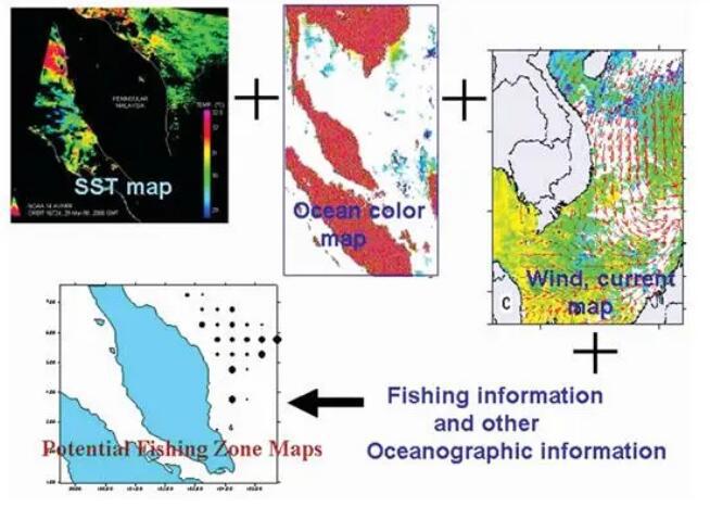
What can ocean satellite remote sensing technology do in fishery?
The first thing is to use marine satellite remote sensing technology to predict the distribution of marine fish resources. The marine environment is a necessary condition for the survival and activities of marine fish. The change of each environmental parameter will have an important impact on the distribution, migration, movement and clustering of marine fish and other marine animals.
Remote sensing can obtain large range of data dynamically and in a large area to discover the changing laws and characteristics of marine fish. Through the relationship between these data and fish distribution, we can analyze the physical mechanism and fluctuation laws of fish distribution, which can greatly help fishery production and management.
To be specific, first, marine satellite remote sensing technology can use marine fishery fishing or survey data to study the characteristics of various elements related to the geographical distribution of marine fish; Second, it can use remote sensing data to predict or simulate the geographical distribution of fish; Thirdly, remote sensing data can be used to explore the composition characteristics of different geographical distribution of fish.
In other words, the ocean satellite remote sensing technology can be used to find out where fish are staying and where they are. In addition to finding marine fish resources, marine satellite remote sensing technology can also be used to manage fisheries and assist the safety of fishing vessels.
Through satellite monitoring, the distribution of fishing vessels, types of fishing vessels, fishing intensity, fish habitat environment and other information can be obtained. At the same time, remote sensing data can improve the accuracy of weather forecast and provide meteorological support for fisheries. Timely acquisition of remote sensing data such as cloud map, wind, wave and sea ice can also improve the safety of marine fishing operations and avoid losses.
With the most powerful assistance of remote sensing satellite, fishermen are no longer afraid of going to sea, but encounter big waves halfway!
Of course, the ocean remote sensing satellite can monitor not only the wind and waves on the ocean, but also the red tide and other disasters. With marine remote sensing technology, remote sensing thematic maps of disaster factors, such as red tide, oil spill and large area pollution, can be made based on the marine environment information and sea state information monitored by remote sensing, so that disaster information can be released to relevant fishery departments and units in time to reduce losses.
In addition, you can always see marine remote sensing satellites in areas such as fishery function zoning, wetland protection, beach development and planning. According to the information of visible light and near-infrared bands in ocean remote sensing, the information of tidal flat and wetland can be retrieved, and thematic maps can be made to provide scientific basis for a series of ocean development, planning and construction.
Based on remote sensing classification, the area and change trend of reed, Spartina alterniflora, Scirpus mariqueter, tidal flat, aquaculture farm, salt farm, reservoir pond and other types of cover in the Yangtze Estuary wetland were obtained.
Ocean satellite remote sensing technology in the world
The ocean remote sensing satellite is so good that of course everyone wants it. At present, there are nearly 100 ocean satellites or earth observation satellites with ocean exploration function in the world. The United States, Europe, Japan and India and other countries and regions have established relatively mature and complete marine satellite systems. Let's take a look at the development of this technology in some major countries.
The United States is the first country in the world to develop marine satellite remote sensing technology. In 1978, the United States successfully launched the world's first ocean satellite SEASAT-A. In the past 40 years, the United States has developed different types of dedicated ocean satellites, such as ocean terrain satellite, ocean dynamic environment satellite and ocean color satellite, and has realized the ability to obtain ocean color and ocean dynamic environment information from space.
The most representative ocean color satellite is the special ocean color satellite "Starfish" successfully launched by NASA on August 1, 1997. It marks the continuation of the global ocean color remote sensing data that has been interrupted for 10 years because the water color remote sensor "Coastal Color Scanner" stopped operating in 1986, and can obtain high-quality ocean color data.
The United States plans to carry out continuous accumulation of global ocean color remote sensing data in 20 years since the launch of "Starfish" satellite. So far, more than 10 major satellites with ocean color remote sensing function have been launched in the world.
NOAA satellite is a civil polar orbit meteorological satellite developed by the United States. Noah can also be used for global ocean, land and space environmental monitoring, and continuously measure and record global ocean wind speed and direction data all day long.
Since the first NOAA satellite was launched in December 1970, it has gone through five generations. The third generation advanced very high resolution radiometer carried by NOAA-15-19 satellite can be used for the observation of sea surface temperature, and the advanced microwave detector can be used for the monitoring of sea ice.
In recent years, NASA has launched a sea surface salinity remote sensing satellite for remote sensing observation of sea surface salinity. Remote sensing of sea surface salinity plays a very important role in the monitoring of the marine environment, the formation and circulation of water masses, and climate prediction. It has become a research hotspot in space geoscience at home and abroad in recent years.
In Russia, the marine satellite series developed in the Soviet Union (including Russia and Ukraine) can be divided into two categories: the first type of remote sensor is based on visible light and infrared detectors; The second type of remote sensor is mainly side-looking radar.
In 1979, the Soviet Union launched the first ocean satellite (Cosmo-1076), which was used for satellite test and measurement of ocean meteorological and atmospheric physical parameters. In 1988, the first practical marine satellite (Okean-O1) was successfully launched. So far, four generations of ocean series satellites have been developed. These Okean series satellites can observe sea surface temperature, wind speed, ocean water color, ice cover, etc.
The European Space Agency's European Remote Sensing Satellite (ERS) is mainly used for environmental monitoring. MetOp series satellites are their main satellites. The advanced very high resolution radiometer of this series of satellites can be used to obtain the sea surface temperature and sea ice information, and the advanced scatterometer can be used to obtain the global sea surface wind field and sea ice information.
Cryosat is a satellite in the "European Earth Explorer Program". This series of satellites use radar altimeters to measure changes in the thickness of land and sea ice sheets, which can accurately monitor polar ice and sea ice floes.
Japan's Ocean Observation Satellite (MOS) is their first series of Earth observation satellites. Another series of satellites in Japan, the Advanced Earth Observation Satellite (ADEOS), is mainly used to monitor global environmental changes and can obtain information about ocean water color and sea surface temperature.
Among them, the advanced microwave scanning radiometer can be used to observe the sea surface temperature, sea surface wind speed and sea ice distribution, the panoramic imager can be used to monitor the ocean carbon cycle, the microwave scatterometer can observe the global sea surface wind field, and the water color and sea temperature scanner can carry out high-precision observation of the ocean, and measure the ocean water color and sea surface temperature.
At present, the United States, Japan, France, Canada, Norway and other major marine fishery countries in the world have established a service system for forecasting fishing sea conditions based on satellite data. South Korea, the United Kingdom, India and other countries have also carried out fishery remote sensing research. Remote sensing technology has become an important technical means for countries to carry out fishery information services.
When did China begin to develop marine satellite remote sensing technology?
China's marine satellite remote sensing technology
China's marine remote sensing satellite research started late. The first marine color satellite HY-1A "Fengyun 1" was successfully launched in 2002, which achieved a breakthrough in China's marine satellite zero and laid a technical foundation for the development of China's marine remote sensing satellite.
In August 2011, China successfully launched the first marine dynamic environment satellite HY-2A, which realized the observation of various marine dynamic environment parameters such as wave height, ocean current, sea surface wind field and sea surface temperature.
HY-2 series satellites can effectively solve the operational monitoring of marine disasters related to the marine dynamic environment, such as storm surge, sea level rise, disastrous waves, typhoons and tsunamis. At the same time, on the basis of the HY-2 series of satellites, the ocean salinity satellite will be developed to form a detailed observation of the ocean temperature, salt, current, wave, wind field and other dynamic environment factors.
In August 2016, Gaofen-3 (GF-3 satellite) was successfully launched, which is China's first C-band multi-polarized synthetic aperture radar imaging satellite with a resolution of 1m. The Gaofen No.3 (GF-3), which was officially put into use in 2017, has greatly improved the situation that China's civil space-based high-resolution SAR data all rely on imports.
This satellite has been widely used in many industries. It can realize all-weather and all-weather monitoring and monitoring of global marine and land resources, as well as high-precision monitoring of marine vessels, islands and coastal zones, as well as all-weather observation of marine disasters such as oil spills, green tides and sea ice.
Therefore, it can effectively support marine environmental monitoring, marine target monitoring, sea area use management, marine rights and interests maintenance, disaster prevention and mitigation and other applications.
After rapid development in recent years, China has gradually formed a series of marine remote sensing satellites represented by marine water color satellite, marine dynamic environment satellite and marine monitoring satellite, providing technical support for China's marine environmental protection, marine resources development, sea area use management, marine rights and interests maintenance and polar ocean management.
These technologies have not been shelved, but have been fully applied to concrete practice. The application of remote sensing technology to marine fisheries in China began in the early 1980s.
The East China Sea Fisheries Research Institute of the Ministry of Agriculture extracted the sea surface temperature data through the meteorological satellite infrared cloud image, combined with the on-site environmental monitoring and fishery production information of the same period, and through comprehensive analysis, drew the quick report chart of the fishing sea conditions in the Yellow Sea and the East China Sea, and regularly provided information services to fishery production units and fishery management departments.
Marine remote sensing satellite is a tool for collecting marine environmental information in a wide range, fast and dynamic way. The use of remote sensing data can help us understand the marine ecosystem and its response mechanism more deeply. Marine remote sensing satellites can also provide socio-economic information and play an important role in the production, management and research of marine fisheries.
Marine remote sensing satellite technology has become an important technical means for marine fishery production, management and research. We hope that it can continue to be a good helper for China's marine cause and explore more marine secrets together.