The fusion and development trend of machine learning and GIS
In recent years, with the continuous development and enhancement of technologies such as neural networks, data mining, the Internet of Things, big data analysis, artificial intelligence, and deep learning, many intelligent methods can be used for data analysis. As an interdisciplinary technology, it is very important to analyze changes in time and space through these intelligent methods, solve previously difficult problems, or expand more possibilities.
Artificial intelligence has even surpassed human accuracy in tasks such as computer vision, natural language processing, and machine translation. The intersection of artificial intelligence (AI) and GIS is creating a large number of opportunities that previously could not be achieved. Artificial intelligence, machine learning, and deep learning are helping us improve crop yields through precision agriculture, combat crime by deploying predictive policing models, predict when the next big storm will occur, and be better able to cope with it to create a better world.
In a broad sense, AI is the ability of a computer to perform tasks that typically require some degree of human intelligence. Machine learning is an engine that makes this possible, using data driven algorithms to learn from data and provide you with the answers you need. A type of machine learning that has emerged in recent years is deep learning, which refers to deep neural networks that are inspired and emulated by the human brain for grading signal processing.
1.Application of Deep Learning in GIS
Machine learning has always been a core component of GIS spatial analysis. Machine learning, deep learning, and artificial intelligence are increasingly used together with GIS for multiple purposes. Integrating machine learning algorithms with GIS can provide better and better results in a shorter time. These tools and algorithms have been applied to geographic processing tools to solve three broad categories of problems.
Through classification, you can use support vector machine algorithms to create a land cover classification layer. Another example is clustering, which allows you to process a large amount of input point data and identify meaningful clusters among them. Prediction algorithms such as geographic weighted regression allow you to use geographic information to calibrate factors that help you predict. These methods are very useful in many fields, and their results can be explained, but they require GIS experts to identify or provide factors that affect our prediction results.
The rise of deep learning
Wouldn't it be better to automatically view the data and find out what these factors should be? This is where deep learning comes into play. Its inspiration comes from a similar way of thinking in the human brain. In deep neural networks, there are neurons that respond to stimuli, and they are connected to each other in layers. Neural networks have existed for decades, but training them well is a key challenge.
So what has changed and made the application of deep learning so successful? The emergence of deep learning can be attributed to three major developments in recent years,data, computing, and algorithm improvements:
Data: Due to the Internet, numerous sensors, and numerous satellites that are imaging the world every day, we now have a large amount of data.
Computing: Cloud computing and GPU have powerful computing power, they are more powerful than ever before, and they are very affordable.
Algorithm improvement: Finally, researchers have now cracked some of the most challenging aspects of training deep neural networks through algorithm improvement and network architecture.
Applying computer vision to geospatial analysis
Deep learning is widely used in computer vision or image intelligent recognition. This is particularly useful for GIS because the rapid generation of satellite, aviation, and drone images makes it difficult for people to analyze images and obtain the desired results through traditional methods.
The following figure shows some of the most important image recognition use cases and how they apply to GIS:
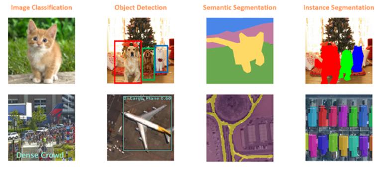
Figure 1. Intelligent Image Recognition Task Applied to GIS
The simplest application is image classification, where a computer assigns labels to images, such as "cats" or "dogs", which can be used to classify geotagged photos in GIS. In the example above, we classified the image as having "dense crowds", and such pedestrian activity classifications can be used for pedestrian and traffic management plans in public venues.
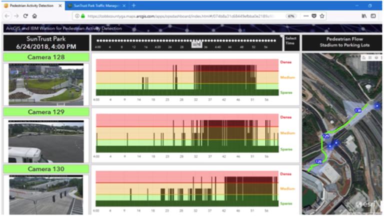
Traffic and pedestrian movement planning in Khob County
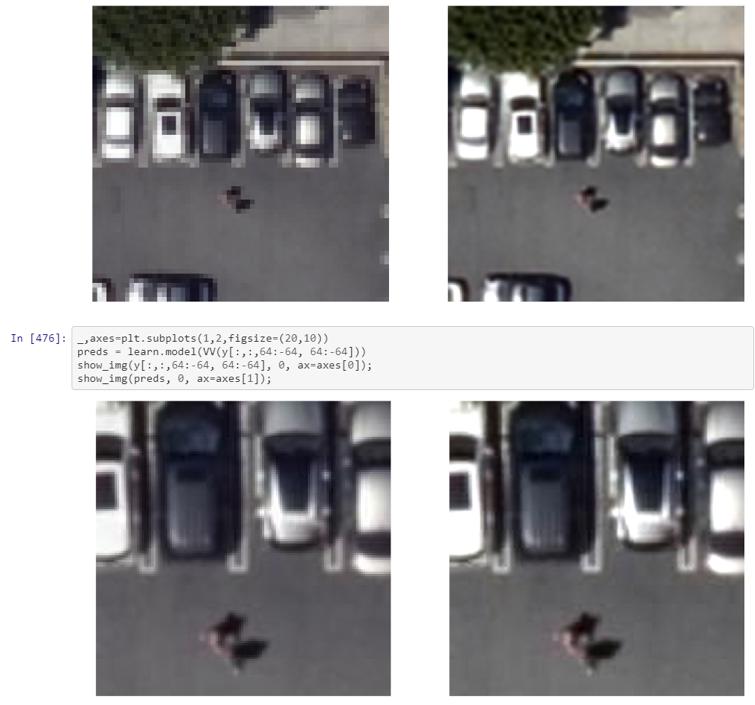
Next, it can be used for object recognition, where the computer needs to find the object and its location in the image. This is a very important task in GIS, finding the content in satellite, aviation, or drone images, and drawing and mapping maps on maps, which can be used for infrastructure mapping, anomaly monitoring, and object feature extraction.
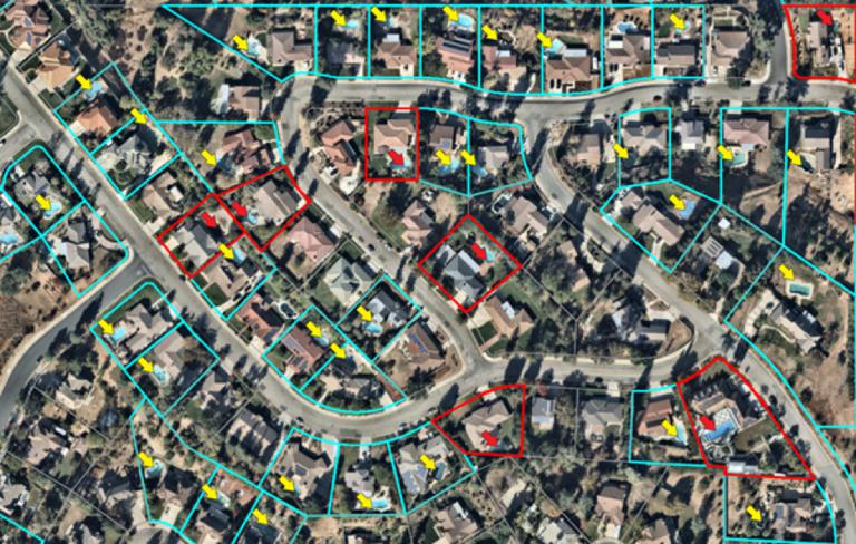
Identify swimming pools in residential areas
Another important task in image recognition is semantic segmentation, where we classify each pixel of an image as belonging to a specific class. For example, in the image in Figure 1, the cat is a yellow pixel, the green pixel belongs to the ground class, and the sky is blue. In GIS, semantic segmentation can be used to classify land cover or extract road networks from satellite images.
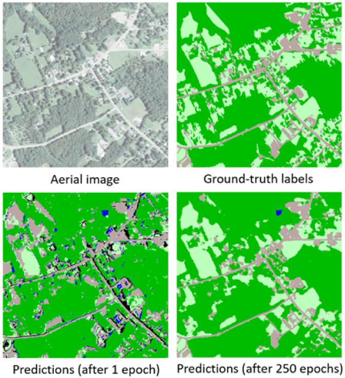
Deep learning of land cover classification and use
Another type of segmentation is instance segmentation, which you can think of as more accurate object detection, where the precise boundaries of each object are marked. This can be used for tasks such as improving the underlay by adding building coverage areas or reconstructing 3D buildings from LiDAR data.
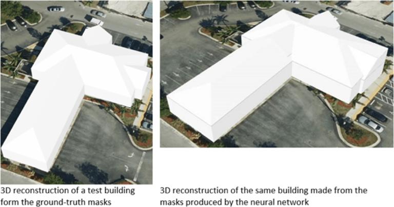
A building reconstructed in 3D using aerial LiDAR images
Learn more about drawing
An important application of satellite image depth learning is to create digital maps by automatically extracting road networks and capturing boundaries.
Imagine the ability to apply a trained deep learning model to a large geographical area and reach a map that contains all the roads in the area, as well as create driving routes using the detected road network. This is particularly useful for developing countries or newly developed urban areas that do not have high-quality digital maps.
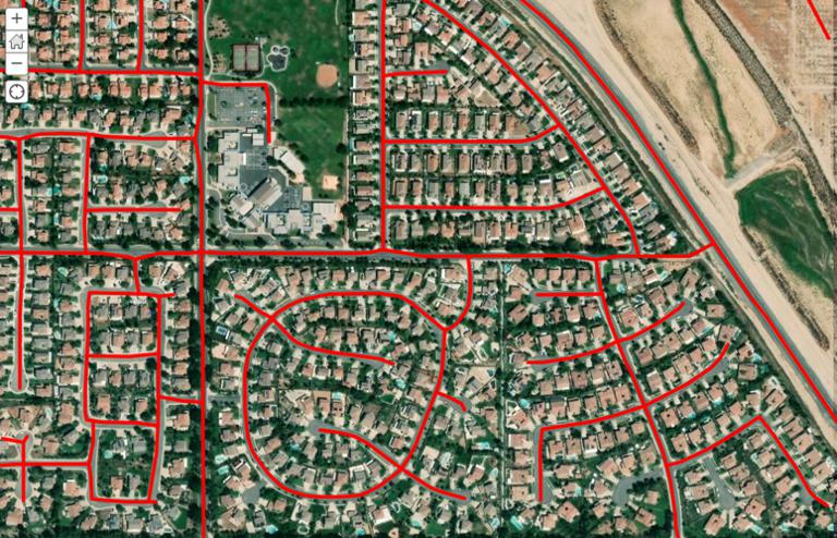
Using Deep Learning to Identify Roads and Convert to Map Features
Good maps require more than just roads, they require buildings. The application of instance segmentation models is particularly useful for building boundary segmentation, and can help create building boundaries without the need for manual digitization.
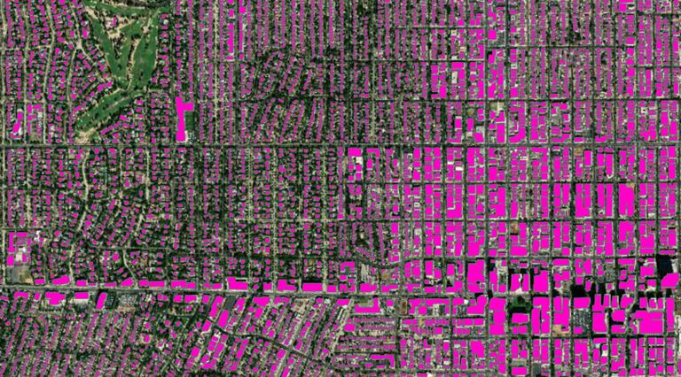
Use tools to extract construction boundaries from satellite images and standardize them
2.Integrated Application of GIS and AI
Most GIS platforms have tools to help complete every step of the data science workflow: from data preparation and exploratory data analysis, to training models, to performing spatial analysis, and finally using the network to publish and share map results.
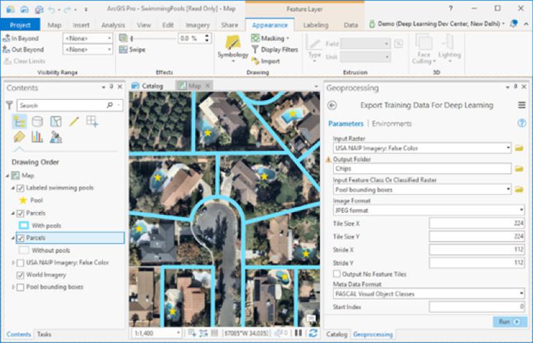
Exporting Training Data for Deep Learning Tools in ArcGIS
Most GIS platforms include tools to assist in the preparation of deep learning workflow data, which can be used to deploy trained models for feature extraction or classification, and large-scale deployment of deep learning models using distributed computing. CNTK, Keras, PyTorch, fast.ai, and TensorFlow can be used for object detection and classification workflows.
Deep learning is a rapidly evolving field that uses code first methods to allow data scientists to leverage cutting-edge research while leveraging industrial grade GIS platforms. Python has become a common language in the deep learning world, and popular libraries such as TensorFlow, PyTorch, and CNTK have chosen it as their main programming language. The support of these languages on the GIS platform means that it is very suitable for integrating with these deep learning libraries and allowing you to extend functionality.
3.Development Trend of Deep Learning and GIS Integration
Deep learning is a rapidly developing technology field, with the most advanced results and new research papers appearing weekly or monthly around the world.
Using Deep Learning to Improve Resolution
New uses for deep learning are for enhancing images, such as increasing the zoom level by using a "super resolution network". This technology can be used to improve the clarity of satellite images, even exceeding the resolution of the sensors used.
Style conversion of satellite images
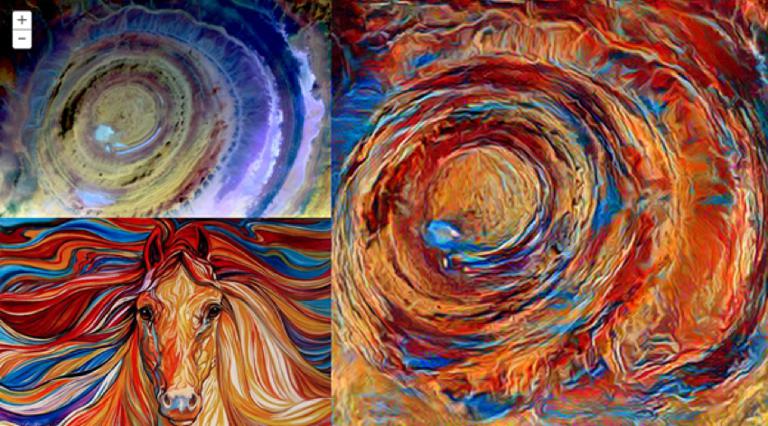
Another new use of deep learning is in the field of "creative (design) intelligence". Neural style transfer technology can be used to generate "map art" and find practical uses in GIS through mapping style transfer.
Catalographic Style Shift
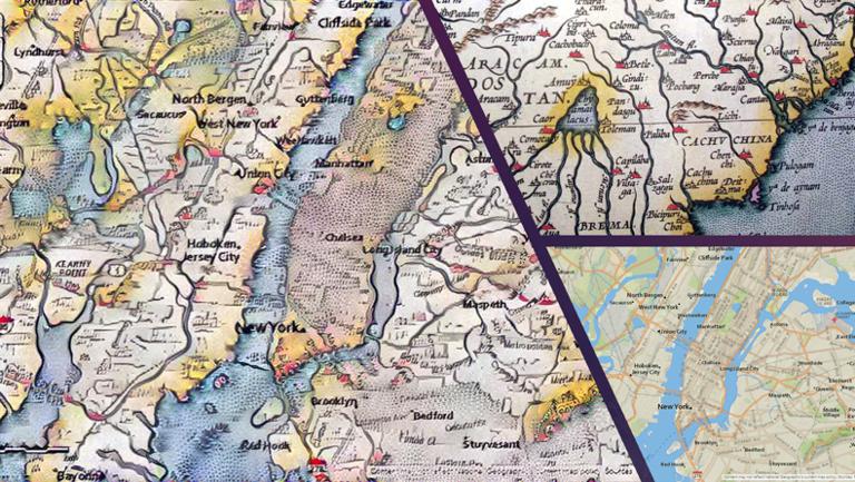
Generative Counter Network (GAN) is an active research field that has always played a pivotal role in the history of machine learning and can be used to generate map blocks directly from images.
Although the above example focuses on images and computer vision, deep learning can also be used equally well to process large amounts of structured data, such as observations from sensors or attributes from the element layer. Applications of these techniques in structured data include predicting event probabilities and geocoding.
Many GIS platform providers and innovative companies are investing heavily in and researching these emerging technologies, developing data models and applications for artificial intelligence and deep learning.