Geographic Information System and its type
Geographic information system
Geographic Information system (Geographical Information System,GIS) is a kind of decision support system, which has various characteristics of information system. The main difference between GIS and other information systems is that the information stored and processed by GIS is geo-coded, and the geographical location and the attribute information related to this location has become an important part of information retrieval. In the geographic information system, the real world is expressed as a series of geographical elements and geographical phenomena, which are at least composed of spatial location reference information and non-location information.
The definition of geographic information system consists of two parts. On the one hand, GIS is a discipline and a new cross-discipline describing, storing, analyzing and outputting spatial information. On the other hand, geographic information system is a technical system, which is based on geospatial database (Geospatial Database) and uses geographic model analysis method to provide a variety of spatial and dynamic geographic information at the right time, which serves for geographic research and geographic decision-making.
Geographic information system has three characteristics:
Firstly, it has the ability of collecting, managing, analyzing and exporting many kinds of geographic information, which is spatial and dynamic.
Secondly, spatial geographic data management is supported by computer systems, and computer programs simulate conventional or specialized geographic analysis methods to act on spatial data, generate useful information, and accomplish tasks that are difficult for human beings to accomplish.
Thirdly, the support of computer system is an important feature of Geographic Information System (GIS), which enables GIS to quickly, accurately and comprehensively locate and dynamically analyze complex geographic systems.
The appearance of Geographic Information System (GIS) is computer software and hardware system; but its connotation is a geospatial information model organized by computer programs and geographic data. When users with certain Geoscience Knowledge use geographic information systems, the data they face are no longer meaningless, but abstract the objective world into modeled spatial data. Users can observe all aspects of the real world model according to the purpose of application, obtain the information of natural process analysis and prediction, and use it for management and decision-making. This is the meaning of information system. A logically reduced and highly informationized geographic system simulates the functions of the geographic system from visual, metrological and logical perspectives, the flow of information and the results of information flow are simulated entirely by the operation of computer programs and the transformation of data. Geographers can extract the spatial and temporal characteristics of different aspects and levels of geographic system with the support of geographic information system. They can also quickly simulate the evolution of natural processes or the results of thinking processes, obtain the results of geographic prediction or “experiment”, and select optimization schemes for management and decision-making.
Geographic Information System and 4M
For geographers, city planners, resource managers, and other people using geographic information, they observe and measure environmental parameters and maps to describe the characteristics of the Earth; they monitor changes in the surrounding environment and build models of processes and activities that affect the environment. These four activities (4M) can be improved and improved by applying GIS technology.
Type of geographic information system
Geographic information systems can be divided into three categories according to their content:
1)专题地理信息系统(Thematic GIS) ,是具有有限目标和专业特点的地理信息系统,为特定的专门目的服务。例如,森林动态监测信息系统、水资源管理信息系统、矿业资源信息系统、农作物估产信息系统、草场资源管理信息系统、水土流失信息系统等。
2)区域信息系统(Regional GIS) ,主要以区域综合研究和全面的信息服务为目标,可以有不同的规模,如国家级的、地区或省级的、市级和县级等为各不同级别行政区服务的区域信息系统;也可以按自然分区或流域为单位的区域信息系统。区域信息系统如加拿大国家信息系统、中国黄河流域信息系统等。许多实际的地理信息系统是介于上述二者之间的区域性专题信息系统,如北京市水土流失信息系统、海南岛土地评价信息系统、河南省冬小麦估产信息系统等。
3)地理信息系统工具或地理信息系统外壳(GIS Tools) ,是一组具有图形图像数字化、存储管理、查询检索、分析运算和多种输出等地理信息系统基本功能的软件包。它们或者是专门设计研制的,或者在完成了实用地理信息系统后抽取掉具体区域或专题的地理系空间数据后得到的,具有对计算机硬件适应性强、数据管理和操作效率高、功能强且具有普遍性的实用性信息系统,也可以用作GIS教学软件。
The establishment of regional or thematic geographic information system with the support of general geographic information system tools can not only save the manpower, material and financial resources of software development, shorten the period of system establishment and improve the technical level of the system, but also make the technology of geographic information system easy to popularize, and enable geoscientists to devote more energy to the development of high-level application models.
Composition of geographic information systems
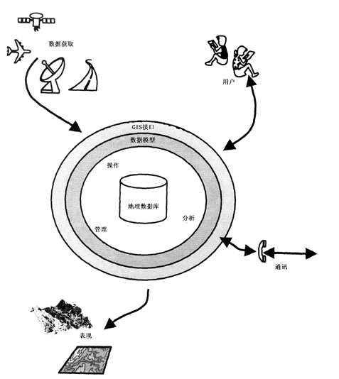
Similar to common information systems, a complete GIS consists of four parts: computer hardware system, computer software system, geographic data (or spatial data) and system management operators. The core part of the system is computer system (software and hardware), spatial data reflects the geographical content of GIS, while managers and users decide how the system works and how information is expressed. The system structure is shown in Figure 1-4.
Computer hardware system
A computer hardware system is a general term for actual physical devices in a computer system, which can be an electronic, electrical, magnetic, mechanical, optical component or device, and is a physical enclosure of a GIS.The scale, accuracy, speed, function, form, usage and even software of the system have a great relationship with the hardware and are supported or restricted by hardware indicators. Due to the complexity and particularity of its tasks, GIS must be supported by computer equipment. The basic components that make up a computer hardware system include input/output devices, central processing units, memory (including main memory, auxiliary memory hardware [3]), etc., which work together to provide the necessary information to the computer system to complete task; Save the data for current or future use; provide the results or information processed to the user. Figure 1-5 shows a common computer peripheral that implements the input and output functions.
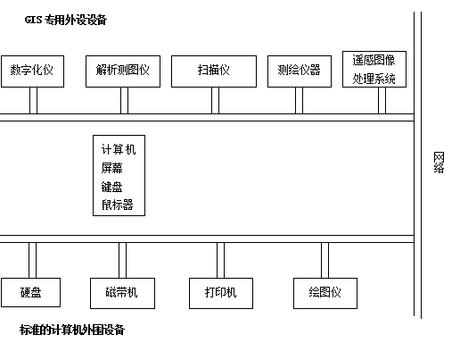
Fig. 5 Computer standard peripherals and peripherals used in GIS
Computer software system
Computer software system refers to all kinds of necessary programs. For GIS applications, which usually includes:
1) Computer System Software
Programming system provided by computer manufacturer, which provides convenience for users to use computers, usually includes operating system, assembler, compiler, diagnostic program, library program, maintenance manual and program description, etc., which is necessary for the daily work of GIS.
2) GIS software and other supporting software
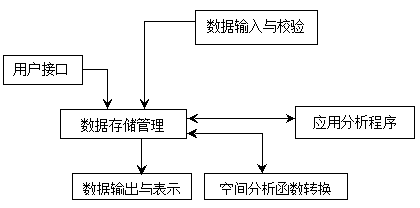
Including general GIS software package, can also include database management system, computer graphics software package, computer image processing system, CAD, etc., to support spatial data input, storage, conversion, output and user interface. The functional structure of the GIS software package is shown in Figure 1-6.
3) Application analysis program
It is a program compiled by system developers or users for a specific application task according to the geographic thematic or regional analysis model, and it is the expansion and extension of the system function. With the support of GIS tools, the development of applications should be transparent and dynamic, independent of the physical storage structure of the system, and constantly optimized and expanded with the improvement of the application level of the system. Applications act on geographic thematic or regional data to form the specific content of GIS, which is not only the part that users are most concerned about for geographic analysis, but also the key to extract geographic information from spatial data. Most of the work of users in system development is to develop applications, and the level of applications to a large extent determines the application of the system and the success or failure.
System development, management and use of personnel
Human is an important component of GIS. GIS is different from a map, but a dynamic geographical model. Only the system software and hardware and data can not constitute a complete geographic information system, which requires people to organize, manage, maintain and update the data, expand and improve the system, develop application programs, and flexibly use geographic analysis models to extract a variety of information to serve research and decision-making. For qualified system design, operation and use, GIS professionals are the key to the application of GIS, and a strong organization is the guarantee of system operation. A well-planned GIS project should include project managers responsible for system design and implementation, technical personnel for information management, application engineers for system customization, and users who eventually run the system.
Spatial data [4]
Natural, social and human economic landscape data referring to the spatial location of the earth’s surface can be graphics, images, text, tables and figures. It is input into GIS by the builder of the system through digitizer, scanner, keyboard, tape machine or other system communication, which is the object of system program function and the substantive content of the real world expressed by GIS through model abstraction. In GIS, spatial data mainly include:
1) Position in a known coordinate system
That is, the geometric coordinates, which identify the spatial position of the geographical landscape in the natural world or in the map containing a certain area, such as latitude and longitude, plane rectangular coordinates, polar coordinates, etc., the digitizer input angle usually uses digitizer rectangular coordinates or screen rectangular coordinates.
2) Spatial relationship between entities
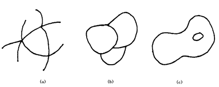
Spatial relationships between entities usually include: metric relationships, such as distance between two objects; extension relationships (or orientation relationships), which define the orientation between two objects; topological relationships, which define the connectivity and adjacency between objects, which are the most basic relationships in GIS analysis, including the pivotal relationship between network nodes and network lines (Fig. 1-7-a), and edges, constitutive relationship between boundary and surface entity (Fig. 1-7-b), including relationship between surface entity and island or interior point (Fig. 1-7-c), etc.
3) Properties independent of geometric position
The so-called non-geometric or abbreviated attributes are geographical variables or geographical meanings associated with geographic entities. Attributes are divided into qualitative and quantitative, the former includes name, type, characteristics, etc., the latter includes quantity and grade; qualitatively described attributes such as soil type, administrative division, etc., quantitative attributes such as area, length, land grade, population size, etc. Non-geometric attributes are generally abstracted concepts, obtained by classification, naming, measurement, and statistics, any geographic entity has at least one attribute, and the analysis, retrieval and representation of the geographic information system are mainly realized through the operation operation of the attribute, therefore, the classification system and the measurement index of the attribute have a great influence on the function of the system.
Three views on GIS [Maguire, 1991]
There are three viewpoints on the definition of GIS: map, database and spatial analysis. The definition of map point of view focuses on the content related to cartography, so GIS is regarded as a map analysis and processing system; the definition of database point of view focuses on the perfection of database design and implementation; a complex database management system is regarded as an integral part of GIS; the definition of spatial analysis point of view focuses on analysis and modeling, GIS is regarded as a spatial information science and not just a technology.