Industry #
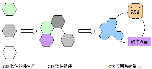
With the socialization of GIS, geographic information has developed into a huge industry. At present, in the United States, there are as many as 10,000 GIS application projects annually, and the output value is more than 1 billion US dollars. At the same time, industrial development and growth are also undergoing differentiation, resulting in new industrial sectors related to geographic information. Industrial differentiation is conducive to the formation of economies of scale and the rational allocation of human and financial resources throughout society, including: In the application of GIS, the life cycle of geographic data is longer than that of hardware and software, and the production of geographic data needs a lot of time, manpower and capital investment. Effective production and maintenance of geographic data is the premise of the socialization of geographic information system. In addition to the construction of basic spatial data organized by the state, special data producers input and maintain geographic data and sell them as commodities, which can improve the efficiency of data production, avoid waste caused by repeated data entry and reduce the cost of GIS application development. As a commodity, data can be sold in the form of CD-ROM, tape and so on. Today, with the rapid development of the Internet, the way of publishing data through the network is more and more used. At present, many companies are engaged in the development of GIS software and system integration business. With the development of software technology, especially the increasing use of component technology in the process of software development, many departments will be formed, such as GIS software component production, GIS software integration, GIS system integration and so on (Fig. 18-2). Fig. 261 Activities in three phases of GIS software production and system integration # The production of GIS software components is to produce GIS software components according to the common component interface specifications, while the assembly of GIS software will be based on specific application requirements, and the specific form of software can be varied. However, the integration of application system will integrate the assembled software with data and hardware equipment to form a complete GIS application. In the traditional stage of GIS application, GIS software vendors provide services from software production to system integration, even including data input and maintenance. In the socialized GIS application, these three stages of activities are provided by different vendors, which can improve the efficiency of software production, ensure the quality of software, and most importantly, the assembled software can be easily used with other vendors. Application system integration to meet the various needs of users. In order to use the function of GIS, an organization can purchase GIS services besides developing or purchasing its own application system, so it needs a special GIS service provider. The scope of GIS service is very wide. The simplest one is the processing and information extraction of data submitted by customers. In addition, GIS technical consultation and GIS authentication can be classified into the category of GIS service. In a word, the purpose of providing GIS service is to help users solve the problems encountered in the process of establishing and using GIS and reduce unnecessary losses. Many organizations have established GIS applications, they are through the project bidding to seek developers, and then the two sides signed a contract to specify the specific content of the project, and then according to the contract to carry out system development. In the process of project development, the developer relies on the user’s needs, but because the user may not understand the specific technology, it is impossible to determine whether the project development is in accordance with its own needs, so it is impossible to monitor the progress and quality of the project. If the problem is found at the end of the project, it will seriously affect the progress of the project, or even make the project progress. Failure. In order to solve the above problems, generally large-scale projects need GIS engineering supervision. Supervisors are composed of experts in the field of GIS. They are responsible for users and understand their needs. By checking the development of projects, problems can be found in time and losses can be avoided. The above describes that in the stage of socialized GIS application, the required GIS industry departments, along with the expansion of application and deepening of application level, may also completely appear new departments.Data production #
GIS software production and system integration #
GIS services #
GIS engineering supervision #
Policy #
In order to promote the socialization of GIS application, some policies can be formulated to improve the breadth and depth of GIS application. In addition, in the process of GIS socialization, a series of policies and regulations are needed to standardize the application of GIS and the operation of industry. The formulation of GIS standards and norms facilitate the sharing and interoperability of spatial data and guide the establishment of GIS applications. In a sense, a good GIS standard is the basis of industrialization. Standards can be formulated by some standardization organizations, such as ISO, OpenGIS, OMG, etc. Or it is promulgated and implemented nationwide by the government as a policy. Usually, the former is directive, while the latter is compulsory. In addition to formulating GIS standards, some government-related GIS organizations (such as China’s surveying and mapping departments) can also participate in the standard formulation work of some international standardization organizations and specialize the international standards to adapt to the specific conditions of their own countries. The establishment of national basic spatial data is a huge project, which can not be completed by any unit alone. It must be organized by the state with the participation of many local units and completed in collaboration. Because many GIS applications are not profitable, this means that project organizations can not afford high data purchase costs, and reorganizing data entry is undoubtedly a huge waste of human resources and time, which to some extent limits the development of GIS applications. The establishment of basic spatial databases by state organizations and the free or low-cost provision of them to non-profit organizations, such as municipal administration departments and scientific research departments, it can reduce the cost of establishing GIS and facilitate the promotion of the application of GIS. Spatial data standard is the premise of establishing basic spatial database. On the other hand, it is necessary to formulate corresponding policies to ensure data sharing. Socialized application of GIS means that many organizations take the initiative to adopt and establish GIS applications in order to improve management efficiency. At the same time, the formulation of some policies can also help GIS technology to be widely accepted. For example, the formulation of some urban planning and the payment of natural disaster insurance must be based on the results of GIS analysis. On the one hand, it makes decision-making more scientific. In addition, it can accelerate the development of GIS application. With the development and growth of GIS industry, there will naturally be similar problems with other information technology industries, such as unfair competition, which need corresponding policies to regulate. The formulation and implementation of norms can refer to other departments of IT industry. At the same time, due to the technical particularity of GIS, it often needs the participation of GIS experts.GIS standards and norms #
Establishment and sharing of basic spatial data #
Provisions for the application of GIS in other areas #
Running specification of GIS industry #
Law #
The rapid development and wide application of computer technology has provided a new way of life for human society, at the same time, it brought a variety of new legal problems, such as:
Computer crime: Computer crime pointer is used for all kinds of criminal activities of computer system, such as illegal intrusion into computer system, theft or illegal use of computer system data, making virus, etc. These activities include both deliberate or curious destructive activities and the use of computer systems for illegal gains.
Software copyright: With the rapid development of information technology industry, many countries have realized the importance of computer copyright protection, and formulated corresponding copyright protection laws and regulations to protect the intellectual property rights of software authors and ensure the orderly operation of information technology industry. In the field of information technology, the objects protected by copyright include programs, data, documents, integrated circuits and so on. Different objects have different specific contents of protection and identification of infringement. Because of the continuous development of technology, copyright law should be adjusted accordingly. Software (including programs, data and documents) is the focus of copyright protection because it is easy to copy.
Right to privacy: The development and wide application of computer technology have a great impact on the right to privacy. The main reason is that personal data can be collected and used conveniently through the convenience provided by computer system. Especially with the development of the Internet, this problem has become more prominent, because when users visit websites, the personal information filled in by registration is likely to be used illegally.
Network legal issues: After the emergence of computer networks, especially the Internet connecting the global network into a whole, new changes have taken place in all aspects, and new problems have arisen, such as copyright of network works, freedom of speech of BBS, content control of WWW, online advertising, network viruses, unfair competition on the network, security of network transactions and privacy rights, etc., which all need to be solved. The original law was amended to accommodate these changes.
The United States was the first country to propose data copyright protection, and its copyright law has made the following provisions for the protection of data copyright:
To incorporate the copyrighted works of others into an editorial work, permission must be obtained from the owners of these works, otherwise it will constitute infringement;
After incorporating an editorial work, the original copyright ownership of each component of the work is not changed. The editor only owns the overall copyright of the data.
There are generally two views on whether data formed by collecting and editing factual information or materials without copyright itself becomes an original work of the editor and is copyrighted by the editor,
Whether the data formed by collecting and editing some factual information or non-copyrighted information becomes the original work of the editor and is owned by the editor, generally there are two views. 1) The principle of “Industrious Collection”. That is, although information already exists, as long as the editor collects data and edits it, it can become a computer. In the process of retrieval form, the editors have copyright if they pay money, time and use certain technical means. 2) Emphasize the creativity of data selection and organization arrangement, and think that only the creative data embodied in the selection and organization of information can be original.
Emphasizing the creativity of data selection and organizational arrangement, it is believed that only data that reflects creativity in information selection and organizational arrangement has originality.
The above rules and principles are often used in dealing with some data copyright disputes, but some specific issues still need further clarification, such as downloading part of the database into one’s own computer and reorganizing copyrighted data.
In the international definition of “Words and Artistic Works” of Berne Convention on Intellectual Property Rights, maps, topographic maps and geographically related three-dimensional works (Maps, Topography, Three Dimensional Works Relative to Geography) are clearly defined as the scope of intellectual property protection. When protecting spatial data in GIS, countries usually invoke the legal provisions of map copyright protection. Compared with general data, GIS data can be obtained by many ways, including digitization of paper maps, interpretation of remote sensing images, measurement instruments and model operation of existing data, which can generate new spatial data. In addition, when developing GIS applications, spatial data can also be purchased. The complexity of data processing varies greatly, including simple coordinate transformation, other methods and complicated professional model operation. Various forms of data are published, such as hard copy, disk, CD, tape and electronic publishing on the Internet. Different purposes of data application, spatial data can be applied to teaching, scientific research, business, public services, management and other fields. In the process of copyright protection, the above factors should be considered comprehensively.
Data acquisition
The spatial data obtained by using measuring equipment, including GPS and flat-panel mapping instrument, is undoubtedly the original work of its producer (including data producer), and the author has complete copyright over it;
The digitization of paper map data needs to distinguish two situations: the original map is a copyright work, and the original map is a copyright-free material. For the former, it is necessary to obtain the permission of the map owner when digitizing. Map digitization is a very arduous task. In the process of digitization, the original data need to be discretized and sampled, and different input personnel use different input methods to obtain different accuracy of data, that is, digitized data can not be equivalent to the original paper map. From this point of view, authors of digital maps should have complete copyright of data.
Data purchase only obtains the right to use data, but does not obtain ownership. The unit or individual that purchases data transfers the data to other units or individuals in private, which constitutes a violation of the copyright of the obligee. This principle is similar to common software purchasing. Software purchasing can be more clearly restricted by licensing. For data purchasing, whether the purchased data can be installed in different computers, whether the data purchased for one project can be applied to another project, and whether the data use license can be transferred like common software, the problem need further discussion.
Remote sensing data are often acquired through purchase, so the purchasing unit only has the right of use, but the remote sensing data are processed and thematic data (such as vegetation cover map, land use map, etc.) are obtained. This process incorporates the idea of the processor, so the data processor has full copyright.
Data Processing: Copyright issues only arise when processing copyrighted electronic data and the processor does not hold the copyright. Data processing requires the processor to invest time and resources, and reflects the processor’s intellectual input. After processing, the original data is no longer explicitly visible in the new dataset. According to the principles of “sweat of the brow” and “creativity,” the processor can generally be considered to hold full copyright in such cases. However, the complexity of data processing varies. For simple transformations, such as projection changes, file format conversions, or adjustments to brightness and contrast in images, the process is often reversible, meaning the original data can be regenerated from the processed result. Therefore, in these cases, the processor cannot claim copyright over the resulting data, as doing so would infringe upon the rights of the original data owner. In practice, drawing a clear line between simple and complex processing is challenging and often requires evaluation by GIS experts.
Data Distribution Formats: Spatial data can be distributed in various forms, including maps, computer-readable media, and the Internet. For copyrighted data, regardless of the distribution format, its copyright should be protected unless the rights holder explicitly states otherwise.
Data application purposes: The use of spatial data can have different purposes, including education, scientific research, public services, business, etc. Generally, the restrictions on the use of data for non-profit purposes can be relaxed appropriately. With the increasing socialization of GIS and spatial data collection, digitization and processing becoming an important part of the GIS industry, it is of great significance to formulate laws and regulations for the protection of spatial data copyright for protecting the interests of data producers and promoting the development of GIS applications. Of course, with the socialization of GIS, the legal problems are not limited to data copyright. The following problems, such as the unfair competition of GIS industry, the confidentiality of spatial data and so on, need the joint efforts of legal experts and GIS experts to put forward reasonable solutions.
Education and assessment certification #
With the development of GIS technology, the demand for GIS talents is increasing. At the same time, the quantity and complexity of GIS knowledge are also increasing for every GIS staff . As a result, many GIS practitioners are seeking opportunities for training and education.
At present, the training and education institutions of GIS mainly include vocational schools, community colleges, universities and colleges, developers of GIS software, units using GIS, etc.
The main ways in which these institutions conduct training include [T.A.WIKLE]:
The courses can be general or specific to an application or software. The former is usually organized by a university, while the latter is usually organized by a GIS software developer (e.g. ArcView 4.0 certification of ESRI). In addition, a GIS application organization needs to train its employees when launching new projects. They also pay more attention to the certification of short training courses when hiring employees, because it is reduced. They have less training workload.
Distance learning: Distance learning is a new teaching method. It is a better choice for those who can not attend the scheduled courses because of their work or other reasons. Participants in distance learning need to take a series of courses to obtain a diploma. The teaching materials of these courses can be sent to remote students via video signals or the Internet.
GIS courses in universities and colleges: In the early stage of the development of GIS, because of the high cost (software, hardware, personnel), few schools can provide GIS teaching. In recent decades, because of the extensive use of computers and the discount sales of commercial software for teaching, universities and colleges can provide a large number of formal GIS courses. By 1996, more than 600 universities and schools in the United States had offered at least one GIS course. At present, many universities in China have established GIS majors in their departments of geography or surveying and mapping engineering. Other related disciplines, such as agriculture, civil engineering, urban and regional planning, forestry and landscape architecture, have also begun to teach GIS courses.
GIS authentication: Generally, GIS authentication requires that students have completed the formal course of GIS, and in some cases, they even need to obtain a degree in GIS. Like a regular degree, accreditation requires a rigorous evaluation process, with the participation of faculty members from universities or colleges. In some cases, research institutes can cooperate with companies to carry out GIS certification activities.
GIS degree: At present, especially in Canada and Europe, many schools have begun to award degrees in Geographic Information Systems and Geomatics. However, few schools in the United States can award degrees in GIS. Some schools award bachelor’s degrees through the department of computer science and mathematics.
At present, some comprehensive universities in China (Beijing University, Nanjing University) and some surveying and mapping universities (Wuhan University of Surveying and Mapping Science and Technology) are able to award bachelor’s, master’s and doctoral degrees in GIS.
Introduction to the GIS Undergraduate Program and Courses, Department of Urban and Environmental Sciences, Peking University:
The undergraduate specialty of GIS in the Department of Urban and Environmental Sciences of Peking University was established in 1998. It has a four-year academic system and is awarded a degree in science or engineering. Students mainly study the theory and technology of GIS and related disciplines, so that they can apply GIS in their specific work and master certain skills of GIS application and development. Professional courses include:
The basic concepts, characteristics, functions and application status of geographic information system; the basic composition and spatial data model of geographic information system; the general methods and processes of geographic information system application; the introduction of popular geographic information system software; the application methods and examples of geographic information system.
This paper introduces how to establish spatial database and graphics database and how to manage and organize spatial data and graphics data. On this basis, spatial query and analysis of region, environment and social economy are carried out by means of geographic information system software.
The spatial data structure, spatial model establishment and analysis, spatial algorithm, basic principles and methods of integration of network GIS and 3S, design and development of GIS software are introduced in depth.
This paper introduces the concepts of geographic information system engineering, the methods of data collection, standardization, quality control and data organization and management, the secondary development technology of geographic information system, the technical scheme and process of system design and development, the construction and personnel management of geographic information system engineering, and the analysis of economic and social benefits of the project;
Physical basis of remote sensing; remote sensing platform; sensor profile; visual interpretation method; applications in land use, forestry, agriculture, landform, hydrology and so on.
This paper introduces the basic format of remote sensing data, the methods of geometric correction, registration and transformation of remote sensing digital images, remote sensing interpretation and classification by human-computer interaction, and spatial analysis of remote sensing images.
Basic principles of surveying; basic principles and use methods of GPS; introduction of data format and interface of GPS; development of map and cartography; cartographic symbols; map projection; introduction of standard topographic maps; information expression of thematic maps; cartographic synthesis; map publishing process;
This paper introduces the concept and principle of terrain model, the establishment of digital elevation model, the calculation methods of slope, aspect, roughness and illumination, three-dimensional terrain simulation, three-dimensional spatial analysis, and the application methods in environmental resources management, land use, military, geological and geomorphological, hydrology and other fields.
Basic principles of computer; introduction of software and hardware; use of operating system; introduction of multimedia; introduction of network and communication.
Taking C and C++ as examples, the basic principles of computer programming are introduced.
This paper introduces the basic principle of data structure, some basic data structures (linear table, string, tree, graph) and related algorithms.
This paper introduces the basic theory of database, database model, relational database design, operation and function of database, basic operation of database, database programming, SQL language, object-oriented database, distributed database, remote data access and development and use of database system under network environment, and the relationship between database and geographic information system.
The development of GIS application needs a large number of GIS professionals, as well as a large number of GIS professional organizations to provide various services. Besides education, it also needs corresponding evaluation and certification system to ensure the quality of talents and services.
At present, the evaluation of the ability and quality of professionals in the field of GIS rely on an “honor system” established in the connection between organizations and individuals. The development of GIS application needs a more structured and objective evaluation mechanism. Among them, due to the abuse of GIS technology by distorting the results, we need to pay more attention to the immoral behavior. Generally, in the field of GIS, the main ways to evaluate and authenticate include:
Certification: Certification focuses on passing examinations or other equivalent evaluation processes, enabling GIS professionals to demonstrate their ability and grasp the knowledge of GIS, so as to obtain an accurate and measurable result. Certification activities are often unofficial and require the supervision of professional associations in similar fields. Certification also requires specific learning and work experience.
Licensing: Licensing is also a way to ensure the ability of GIS personnel. It can also be called registration. It is a compulsory process through which the government gives some individuals permission to engage in certain fields. To obtain a permit, the applicant must pass a test and may need to complete a certification procedure or obtain a degree. The purpose of the permit is to protect the rights of the public. When an individual is recognized to have engaged in illegal or immoral activities, his or her permit may be withdrawn. In many countries, land surveyors need permits.
Accreditation: Accreditation is not for individuals, but for the certification process of GIS educational institutions, including courses, the quantity and quality of teachers, facilities and so on. For example, in order to ensure quality, the authorization process stipulates the minimum number of courses. Authorization is carried out through professional organizations to ensure the quality of GIS education.
The activities of GIS education, evaluation and certification enable GIS application organizations to get enough qualified GIS professionals. The implementation of these activities also needs the support of relevant policies and regulations. Among them, the standardization of evaluation and certification process is an important aspect. The 22nd theme of ISO/TC 211 standard series defines the standards in this respect.