Application model and classification of GIS #
Geographic information system can be divided into general geographic information system platform and GIS application oriented to specific topics or regions. The former provides basic spatial information processing scheme, which can be applied in various fields. Generally, it is completed by specialized software developers. Its development process is similar to that of common software systems (such as database management system, desktop publishing system, etc.). They often provide specific technical means for a user unit. Specifically, according to its application mode, GIS applications can be divided into two categories: scientific research tools and office service systems.
Scientific research tools take GIS as the application model of scientific research tools, emphasize the acquisition and analysis of scientific computing results, and regard GIS as an auxiliary means of scientific research. It is mainly used in scientific research projects in the field of geoscience. It needs not only the functions provided by the general software of geographic information system, but also a variety of professional analysis models.
Office service system: Office service system is applied to government departments and enterprises involved in spatial data to improve management efficiency and make good decisions and achieve organizational goals.
According to its application level, office service system can be divided into STPS (Spatial Transaction Process System), SMIS (Spatial Management Information System), SDSS (Spatial Decision Support System) and Expert System.
The goal of transaction processing system is to process a large amount of spatial information quickly, timely and accurately, which can effectively automate daily transactions. It focuses on the collection, processing and storage of spatial data for future use in various large-scale applied geographic information system data acquisition departments and specific affairs departments, including mapping, resource survey, cadastral management, map publishing and other fields.
Spatial management information system (SMIS) is developed based on spatial transaction processing system. In addition to providing efficient information processing, it also provides decision support information for decision makers, including query and statistics of data and analysis of professional models. SMIS uses professional models to process and analyze data in order to deal with and manage deterministic problems in business work and provide decision-making services.
SDSS provides decision-makers with a simulation decision-making process and a decision support environment for choosing alternatives. SDSS emphasizes the validity of system reasoning and is more applied to macro decision-making process.
Expert system is a computer-based information system that can imitate the process of manual decision-making. It consists of knowledge base, inference engine, interpretation system, user interface and knowledge acquisition system. It enlarges the application scope of computer and makes it develop from traditional data processing to intelligent reasoning. SMIS can provide information to help decision-making, SDSS can help improve the quality of decision-making, only expert system can use intelligent reasoning to make decision and explain the reasons for decision-making.
The boundaries between the above application modes are not absolute. A decision support system can use an analysis model consistent with the scientific research tools. In a broad sense, the ultimate goal of all geographic information system applications is to make spatial decisions.
In addition to dividing GIS application from application mode, it is divided into small, medium and large applications from scale. Small-scale GIS uses less data and less users of the system. It focuses on the development and application of professional models for a department or specific field. Medium-sized GIS is applied to many departments with large amount of data, which runs in LAN or MAN environment and focuses on decision support. Large-scale GIS applications have a large number of users and huge amounts of data, focusing on data management, and through the network to achieve distributed computing and data management, and through the Internet to publish spatial information.
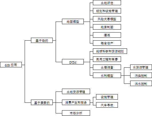
In addition, considering the specific application areas of GIS, the application of GIS can be divided into three elements (Fig. 15-1). Each application of GIS corresponds to the specific coordinates of the three-dimensional space (Table 15-1). Fig. 227 Division of geographic information system applications # 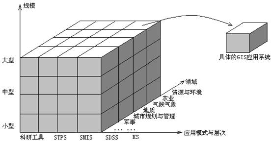
Table 15-1: Examples of ternary partitioning for GIS applications
Name | Scale | Application patterns and levels | Field | ||||||||||||||||||||||||||||||||||||||||||||||||||||||||||||||||||||||||
Soil and water loss system in small watershed of XX | Small-scale | Scientific research tools | Environment | ||||||||||||||||||||||||||||||||||||||||||||||||||||||||||||||||||||||||
Land allocation system in XX urban | Medium-scale | Space transaction processing system | Cadastre | ||||||||||||||||||||||||||||||||||||||||||||||||||||||||||||||||||||||||
Management system in XX forest farm | Medium-scale | Spatial management information system | Forestry | ||||||||||||||||||||||||||||||||||||||||||||||||||||||||||||||||||||||||
Big city municipal management system in XX | Large-scale | Spatial management information system | City management | ||||||||||||||||||||||||||||||||||||||||||||||||||||||||||||||||||||||||
Sustainable development decision support system in XX Province | Large-scale | Spatial decision support system | Resources and environment The division of GIS from the perspective of application domain The data model of GIS is divided into field model and factor model. Fig. 15-2 shows the application of these two models in different fields. Fig. 228 The application fields of GIS are divided according to field model and factor model[N.R. Adam & A Gangopadhyay]. # Once an organization decides to establish a geographic information system for its own unit, it can adopt three ways: one is to purchase and implement it in the organization, the other is to invite software developers to develop it, and the third is to develop it by personnel within the organization, which can be professional geographic information system personnel or end users. The purchase of GIS can be divided into the purchase of GIS platform software for secondary development, the purchase of complete software products, the purchase of complete GIS system and the purchase of GIS services. Inviting a software developer to develop a complete software product or system can also be considered as a form of system purchase, but the time from purchase to system run is longer than that from direct purchase. When inviting developers to develop, there are two specific ways: contractual development and cooperative development. The former is developed by developers independently, which is also called “turnkey” system. The latter can be developed by users’technicians in the process of development, and the two sides cooperate to complete the whole system. This way is conducive to the accurate grasp of the problem domain when developing the system. The above-mentioned GIS applications have their own advantages and disadvantages (Table 15-2). Each organization can decide which scheme to adopt according to the specific situation. Table 15-2: Comparisons between GIS Application Schemes [According to Aronoff extension] Implementation Programme User Development Purchase universal platform Purchase complete softwares Purchase complete systems Purchase Service Contract Development Cooperation Development Provider dependency Low Low High Very high Very high Very high Middle Up to system runtime Long Long-medium length Short Very short Very short Long-medium length Long-medium length Initial cost Low Medium Medium High High High Medium Manpower cost High Medium Low Low Very low Low Medium Risk and uncertainty High Lower Low Low Medium High Medium Flexibility Absolutely Absolutely Medium Medium Indefinite High Absolutely Technical requirements for users Very high High Medium Medium Very low Medium High Utilization of existing resources High High Medium Low Very low Low Medium-high If the organization that wants to build GIS application is not to buy a ready-made, directly usable GIS system, then it means to carry out system development work, whether the system is self-development, contract development or cooperative development. From the beginning of the establishment of requirements to the final operation of the system, the activities in this period are collectively referred to as GIS application projects. Usually a project consists of four phases: identifying requirements, proposing solutions, executing projects and ending projects. These four phases constitute the life cycle of the project (Figure 15-3). Fig. 229 Project Lifecycle [J. Gido] # Identifying requirements is carried out by organizations preparing to establish GIS application systems, including recognizing the existing problems of current organizations, preparing to use GIS to solve the problems in which areas, and analyzing the feasibility of the project in order to carry out project budget and other issues. If the GIS application is developed and established by the user, then the proposed solution, the execution of the project and the completion of the project are all completed by the user. If you need to be developed by a GIS developer, you need to consult them for a solution and sign a contract, and the former can be done through bidding. After signing the project contract, the developer is mainly responsible for the implementation of the project, and the user cooperates with the developer until the end of the whole project. Figure 15-4 depicts the establishment process of these two geographic information systems. Fig. 230 Geographic information system project process (A: indicates that the user sets up the system; B indicates that it is established by the GIS developer through bidding) # Principles, Technologies, and Methods of Geographic Information Systems 102 In recent years, Geographic Information Systems (GIS) have undergone rapid development in both theoretical and practical dimensions. GIS has been widely applied for modeling and decision-making support across various fields such as urban management, regional planning, and environmental remediation, establishing geographic information as a vital component of the information era. The introduction of the “Digital Earth” concept has further accelerated the advancement of GIS, which serves as its technical foundation. Concurrently, scholars have been dedicated to theoretical research in areas like spatial cognition, spatial data uncertainty, and the formalization of spatial relationships. This reflects the dual nature of GIS as both an applied technology and an academic discipline, with the two aspects forming a mutually reinforcing cycle of progress. |