GIS requirements acquisition #
Requirements acquisition is the first step in software development activities, and obtaining a correct requirement description is a prerequisite for successful software. Generally speaking, user requirements are divided into two categories, functional requirements and non-functional requirements, the former defines what the system does, including inputs, outputs and the transformation between them, while the latter defines the characteristics of the system when it works. such as efficiency, reliability, security, maintainability, portability and so on. Specific requirements acquisition include:
Physical environment, location of physical equipment and concentration of their distribution
Interface, interface with other software systems and data format requirements
User or human factors, including the proficiency of the system user, the training required to use the system
Function, what does the system want to accomplish, and what is the performance?
Documents, which documents are needed and which readers they are aimed at
Data, data format, data accuracy, amount of data, frequency of receiving and transmitting data
Resources, use the equipment needed by the system, develop the necessary human resources, computer resources, schedules
Security, control over access to information, backup of data, etc.
Quality assurance, system reliability requirements, average system error time, portability, maintainability, etc.
In the process of obtaining the requirements of geographic information system, its content is basically the same, but additional consideration should be given to data, organization and so on.
Data: data plays an important role in a GIS application system. When obtaining the demand, the factors related to the data include: (1) the output style of the data: including screen display, Web release, publication, engineering drawings, etc.; (1) the contents and requirements of the output data: what the output data should include, the accuracy of the data, scale, etc. (3) the distribution of the data: whether the data is centralized or distributed management (1.4) existing paper maps: the contents of existing paper maps, its scale, timeliness, whether it involves confidentiality; (1.5) the existing electronic data: data form (raster / vector / attribute database), data format, integrity, accuracy, projection mode, scale and other factors. (1.6) data entry: the amount of data, the support of input equipment, including digitizers, scanners and software, the number of personnel who perform data entry, and whether data entry can be completed within the scheduled time; (1.7) data purchase: data volume and price;
Because the application of geographic information system is generally aimed at professional fields, personnel should not only consider general users, but also listen to the opinions of domain experts, model their theories and experiences, and complete them in the system.
The organization’s existing organizational structure, the responsibilities of the relevant departments, business processes, how GIS is reflected in its business processes, and possible organizational changes caused by the application of GIS.
There are a variety of ways to obtain demand, including face-to-face interviews, telephone interviews, visits, questionnaires, access to relevant information in the field, and so on. In the development of geographic information system, because the concept and function of GIS have not been deeply understood and accepted by users, the use of GIS special report can well encourage users to put forward their requirements. If time and funds permit, the development of a prototype system can also better tap the needs of users.
GIS requirements specification #
In the requirements acquisition phase, the user requirements described in natural language are obtained, but there are inconsistencies and ambiguities, which should be solved through the requirements specification. At present, there are many methods to support requirements specification, such as functional decomposition method, data flow method, information model method (entity relation model), object-oriented method. Each method is supported by a corresponding conceptual system, symbolic representation, and tools.
The result of the requirement specification is formal or semi-formal, the system requirements report, it must completely describe the problem domain and be able to adapt to the change of requirements, in addition, it must meet the needs of users, analysts, designers and developers to communicate, in other words, the symbols and descriptions in the requirements report have the same meaning for all kinds of related people.
As repeatedly emphasized, the object-oriented analysis method well solves the problems of problem space understanding, requirement variability, communication and so on. Applying the general object-oriented analysis method to GIS can describe the system requirements, but because GIS pays more attention to spatial objects and spatial models, it is often necessary to deal with some specific spatial object classes and specific spatial relations (topological relations, azimuth relations, metric relations, etc.) in GIS, specialize and extend the basic object-oriented methods, and use specific symbols to represent these classes and relations. It can make the expression of the demand report more concise and convenient for the exchange of information.
An extension to the Coad/Yourdon method-GeoOOA (part, George K ö sters)
GeoOOA distinguishes between basic classes and four geographic class types. Here are the class symbols for GeoOOA: Fig. 245 Basic class and GeoOOA class # 
Some services include read and write operations and geometry standard services give GeoOOA classes, such as calculated area, length, relationship detection, and so on.
The geographical class forms a hierarchical general-special relationship, the grid class is the special case of the regional class, while the region, line and point are the specialization of the abstract geographical class.
GeoOOA also provides the whole-part structure primitive of the topology, which is only suitable for spatial objects, and the whole part of the structure can be divided into: Covering, Containing, Partition.
Overlay: the whole object and part of the object belong to the same space class, and the whole geometry is covered by the union of partial geometry.
Contains: the overall geometry contains part of the geometry
Segmentation: it is an inclusive structure, but has two characteristics, that is, the whole geometry and part of the geometry belong to the same class, and part of the geometry forms the division of the whole.
The graphical representations of the three primitives are as follows:
Overlay
Include
Split up
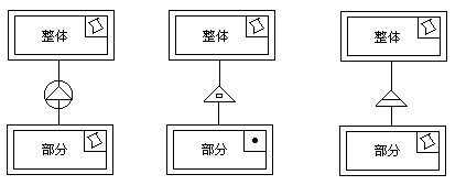
Fig. 246 Overall relationship between parts in GeoOOA #
To give an example to illustrate these three kinds of whole-part relationship, in a provincial administrative region (regional category), there are many television stations (point category), each television station has its own coverage (regional category), and the province is divided into many county-level divisions (regional categories). Due to the overlap between the coverage of stations, and generally speaking, the coverage of all stations is larger than that of the province. Therefore, the provincial administrative regions and the coverage form a whole-part relationship, while the provincial administrative regions and stations include the whole-part relationship, and the provincial administrative regions and county administrative regions are divided into whole-part relations.
By using GeoOOA, the spatial relationship is expressed directly in graphics, which reduces the number of text specifications in the requirements report.