Geo-Information Science
Several related concepts
In recent decades, with the development of remote sensing, global positioning system, geographic information system and computer network technology, a series of new and similar terms related to geographic information system have appeared, such as Geographical Information Science, Geomatics( Geo-Informatics[Gong Peng], Geospatial Informatics [Li Deren]), Geo-Informatics, Geo-Information Science and so on. These concepts have not been put forward for a long time, and their meanings are overlapping. At present, there are some disputes about their exact translation in China. Here we introduce the concepts and contents of Geographical Information Science,Geomatics, Geo-Information Science。
Geographic Information Science
Geographic Information Science was proposed by Goodchild in 1992. Compared with Geographic Information System, it focuses more on treating geographic information as a science rather than merely a technical realization. It mainly studies a series of basic problems in the process, storing, extracting, managing and analyzing geographic information by means of computer technology, including:
Distributed computing
Cognition of geographic information
Interoperability of geographic information
Scale
Future of spatial information infrastructure
Uncertainty of geographic data and analysis based on GIS
GIS and society
Spatial analysis of geographic information system in environment
Acquisition and integration of spatial data, etc
Geographic information science not only studies geographic information technology, but also points out the importance of basic theoretical research to support the development of geographic information technology。
Geomatics
Geomatics is defined as the science and technology of acquiring and managing spatial reference data in the process of production and management of spatial basic information [Gagnon]. Geomatics has other definitions, which are expressed differently, but the gist is basically the same:
Definition of spatial reference basis
Establishment and use of methods, techniques and tools for locating and measuring spatial reference objects and phenomena
Integration of data in different reference systems
Providing eligible data
Using computer technology to improve data processing, storage and distribution
Geomatics includes traditional surveying and mapping fields such as geodesy, cadastral survey, photogrammetry and bathymetry, as well as new fields such as remote sensing and spatial information system. It can be considered as a more comprehensive and comprehensive subject system proposed by surveying and mapping in response to the great demand for spatial information in modern society。
Geo-Information Science
With the development of remote sensing, global positioning system and other technologies with geographic information system technology as the core and their mutual penetration, 3S integrated technology system has gradually formed, which provides a new analysis method and technical guarantee for solving modern geoscience problems with wider regional scope and higher complexity. Since the 1970s, due to the problems of population, resources, environment and development faced by the whole human society, more and more attention has been paid to the research of global change and sustainable development, which ultimately contributed to the emergence of Geo-information science。
Geo-information science studies the movement state and mode of material flow, energy flow and human flow in the earth system by means of information flow (Fig. 19-1). It consists of three parts. Geo-informatics is the main body of its theoretical research, Geo-information technology is its research means, and global change and regional sustainable development are its main application fields. [Chen Shupeng]
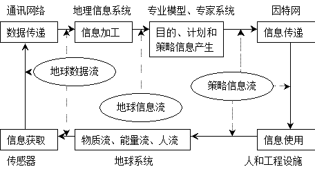
Figure 19-1: The relationship between information flow and material flow, energy flow and human flow in the Earth system
Research contents of Geo-information science
The essence of geo-information science is to reveal the law of the occurrence, development and evolution of the earth system from the perspective of information flow, so as to realize macro-control of resources, environment and society. The research on the mechanism of geo-information as the core of its theory includes:
The structure, nature, classification and expression of earth information;
Information transmission mechanism, physical process, gain and attenuation as well as formation mechanism of information flow between layers of the Earth’s sphere;
Spatial knowledge of earth information and its uncertainty and predictability;
The space-time transformation characteristics of the interaction between material flow, energy flow and human flow are simulated by the earth information;
The basic theory of earth information acquisition and processing。
As a research means of Geo-information science, geo-information technology includes:
Earth data acquisition technology: Use the obtaining earth data from the outside world to record the nature and state of the earth. The development of earth data acquisition technology such as remote sensing and global positioning system has formed a global monitoring and operation system. Establishing a multi-level and three-dimensional Earth Observation System (EOS) is the main technical means for fast acquisition and update of earth data。
Earth information simulation technology: It is used to transform the earth data into the earth information, including the processing and regeneration of the earth space information, and to obtain information about the purpose, plan and strategy of solving a certain earth space problem。
Earth information dissemination technology: It is used to transfer spatial data and disseminate information。