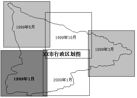
In the process of establishing GIS application, software development and data processing are the two most arduous technical tasks. The management of these two parts directly affects the success or failure of the whole project. Although there are many technologies and methods in software engineering, such as structured method, object-oriented method and so on, which are used in the development process to improve efficiency, the management of the development process is always an important factor determining the success or failure of a software project. For development management, there is no “universal” approach that can be applied to all software development processes, but following the principles in management can better ensure the quality and development efficiency of software products [B.W. Boehm]. These principles are also applicable to the development of GIS platform software. Strict management with phased life cycle planning: In the whole software life cycle, there are many different kinds of work to be done. This principle means dividing the software life cycle into several stages and formulating strict plans to manage software development and maintenance. Usually, the following six types of plans should be formulated and strictly implemented: project outline plan, milestone plan, project control plan, product control plan, validation plan and operation and maintenance plan. Insist on stage review: The quality assurance of software cannot wait until the end of coding. Firstly, most of the errors are caused before coding. Secondly, the later the errors are discovered and the cost is higher. Therefore, strict reviews are needed at each stage in order to detect errors in the software development process as early as possible. Strict product control: In the process of development, the command of users will inevitably change. In order to meet their changing needs, they often have to pay a higher price, which requires strict product control. The commonly technology is configuration management. Using modern programming techniques: Practice shows that the use of advanced programming technology can not only improve the efficiency of development, but also improve the maintainability of software. These technologies include structured analysis, design, programming technology and object-oriented analysis, design, programming technology, etc. The results should be clearly reviewed:Software product is the product of thinking, it determines that the work process is difficult to evaluate and manage, and it is difficult to measure accurately. In order to improve the visibility of the development process and manage, the responsibilities and product standards of the development organization should be defined according to the overall objectives and progress. Development teams should have fewer and better staff: The quality of software development team members should be good, and the number of people should not be too large. The development efficiency of high-quality personnel may be several to dozens times higher than that of low-quality personnel, and there are fewer mistakes. The increase in the number of groups will cause difficulties in communication. Recognize the necessity of continuous improvement of software engineering practice: because of the continuous progress of technology, we should take the initiative to adopt new technology, and constantly sum up experience in order to constantly improve engineering practice. For a project, following the first six points can ensure the success of the project, and this principle enables the software organization to develop continuously. In a GIS application project, it is usually necessary to input and process a large amount of data, mainly spatial data. If proper data management is not adopted, the project may be confused or even fail for the following reasons: Data quality can not meet the project requirements; The data are not fully input or processed, resulting in project delays; Data is repeatedly entry or proceed, resulting in waste of personnel and time; When data processing and model operation are carried out, the latest data are not used in time. In order to avoid these problems, it is necessary to strictly control the process of data input and processing and data quality. Generally, the spatial data sources of GIS application projects include: GPS data, photogrammetric data, survey data, satellite remote sensing data, and existing non-digital maps. The principles of treatment and quality control vary between sources. For GPS data and surveying data, only simple data is normalized (such as format conversion, topological relationship establishment, etc.)by using GIS. The accuracy is determined by GPS or surveying equipment, and there will be no new errors in data processing. Photogramm etric data and satellite remote sensing data usually need a series of corrective operations, and then automatic or semi-automatic interpretation to extract thematic information. Finally, they are usually converted into polygonal data and exported to GIS applications. The error sources include corrections (including radiation correction and combination correction) and misclassification in the classification process. The input of paper maps can be done by hand tracking digitization and scanning vectorization. The error comes from the digitization process and is closely related to the working attitude of digitizers. In addition, digitized data is often less current. The progress control of data input and processing can adopt common milestone method or Gantt chart method. If the scope of the workspace is large and each data processing unit covers only a part of the workspace, the method shown in Fig. 15-9 can be used to express the progress. The advantage is that it is more intuitive and it is not easy to omit data. Fig. 234 Figure 15-9: An intuitive example of data input schedule management method # (the time in each rectangle in the figure indicates the time that the data should be completed, the dark gray rectangle indicates that it has been completed, and the light gray rectangle indicates that data entry and processing are in progress) If there is a large amount of data in the project and multiple data files are needed to store the data, then the naming rules of the files need to be defined at the beginning of the work to express their data contents through the file name to avoid confusion in management. For example, the file name SO01DG is used to represent the first digitized soil map (SO:Soil, soil; 01: first time; DG: digitized). The information expressed through the file name can include topic, processing carried out, time, processor, data area scope, and so on, but too long a file name can also cause difficulty in memory. In addition to defining file naming rules, other descriptive information, including data sources, numerical range of objects, map projection, accuracy, data dependency and other metadata, can be used to build data dictionaries. Data dictionary can be retrieved to master the progress of data.Software development management #
Data management #