Architecture and components in the GIS domain
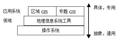
According to the application purpose, geographic information system can be divided into regional geographic information system, thematic geographic information system and geographic information system tools, which constitute the GIS domain (Domain). The so-called domain refers to the collection of systems or applications that share a certain Functionality. In other words, the domain represents a set of common aspects of the application system. For GIS, its shared function is to input, manage, analyze and represent spatial data, which is exactly the function provided by GIS tools (figure 16-6).
Corresponding to the specific application domain, for the domain, we can implement domain engineering, get the domain model, and establish the domain-specific software architecture (DSSA, Domain-Specific Software Architecture). DSSA is a high-level design that can meet the needs of many systems in the domain. When developing specific application systems, DSSA can be used to connect and organize domain components (Component) to support software reuse and improve the efficiency and quality of software development.
For geographic information system, implementing domain engineering and obtaining DSSA can not only guide the development of specific application systems, but also DSSA can be directly used as the software architecture of GIS tools.
The core functions of GIS include the input, management, analysis and presentation of spatial data, and these functions form a relatively complete data processing flow, taking into account the combination with remote sensing and global positioning system, the following system structure is formed (figure 16-7). This view more reflects the business logic of the geographic information system, and in order to be suitable for specific applications, the structure can be specialized-similar to object-oriented, deriving a subclass from the parent class-to form a more specific architecture.
Depending on DSSA, components can be assembled to form specific application systems. Component-based technology has become the mainstream of software development technology. It develops from object-oriented technology and is an important way to develop efficient and low-cost programs.
In order to construct a system through assembly, components must be able to cooperate with each other, that is, interoperability, which is achieved by defining the interface specification of the component. For components, in addition to interoperability, it should also support distributed network computing, that is, component interoperability can be based on heterogeneous platforms, and its implementation needs the support of distributed computing platform (DCP-Distributed Computing Paltform).
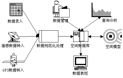
Fig. 138 Figure 16-7:GIS Domain Architecture: a Workflow View
At present, there are many kinds of component technology standards, among which CORBA (Common request object broker Architecture-Common object request broker architecture) of OMG (object Management Organization) and OLE/COM/DCOM technology of Microsoft are two main and widely adopted standards.
COBRA defines a distributed architecture with open soft bus, in which objects from different vendors and running on different operating systems can interoperate. The communication between CORBA objects is mediated by object request broker (ORB,Object Request Broker) and can be implemented on a variety of popular network communication protocols. Interface description language (IDL,Interface Description Language) is used to describe object interfaces, which is language-independent, so that all CORBA objects are described in a consistent manner.
Microsoft’s DCOM (distributed object component Model, Distributed Component Object Model) technology is an extension of the original COM technology to support the communication between objects of different computers on the network. COM defines the binary standard of the interface, including interface interaction, managing objects and their resources, and so on. DCOM makes objects interoperable through the network by increasing the support of network protocols. DCOM technology supports reuse, location independence, extensibility and so on, and its execution performance is good, so it is widely supported by software developers based on Windows platform.
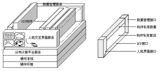
Fig. 139 Figure 16-8: DCP-based GIS architecture and artifacts: an implementation view [OpenGIS Consortium]
For GIS software development, component technology not only realizes reuse and supports distributed interoperability, but also has the following two advantages:
Data is the most important part of GIS. At present, each software has different data formats, which makes it difficult to share and protect users’ existing investment. Component technology can realize data sharing through the support of interoperation.
The functions of GIS cover a wide range of areas, including graphic operation, image processing, cartography, database management, projection transformation and so on. Using component technology, the specific functions of different professional areas can be realized as components and assembled to form a software system, avoiding the need to learn multiple professional areas at the same time.
Figure 16-8 shows a GIS architecture and a conceptual model of components, in which the architecture has multiple “slots” and components are “Plugable”. This structure is similar to the computer motherboard. With the support of DCP, according to the workflow structure described in figure 16-7, cross-platform GIS software can be easily implemented.