Research contents #
The research content of GIS mainly focuses on the following three aspects, as shown in Fig. 9 . These three research areas are interconnected and mutually reinforcing. Fig. 9 GIS content system # 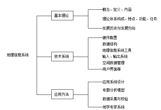
Geographic Information Systems emerged from the needs of geographical research and practical production. The application of GIS has driven continuous refinement of the technical system and gradually advanced GIS theory. Theoretical research, in turn, guides the development of a new generation of highly efficient Geographic Information Systems, constantly expanding their application domains and deepening their practical impact. Meanwhile, the growing application of GIS continues to raise new and higher demands for theoretical research and technical methodologies. This includes studying the concepts, definitions, and essence of Geographic Information Systems; researching the information theory of GIS; establishing the theoretical framework of GIS; investigating the composition, functions, characteristics, and tasks of GIS; summarizing the developmental history of GIS, and exploring theoretical issues such as the future directions of GIS development. This includes the design and configuration of GIS hardware, the structure and representation of geospatial data, input and output systems, spatial database management systems, user interface and user tool design, development of GIS tool software, creation of microcomputer-based GIS, and the research and development of web-based GIS, among others. This includes the design and implementation of application systems, data acquisition and validation, spatial analysis functions and thematic analysis models, methods for integrating GIS with remote sensing technology, and research on geoscientific expert systems. In summary, the core components of Geographic Information Systems primarily include: relevant computer software/hardware; acquisition of spatial data and computer input; spatial data models and digital representation; database storage and processing of data; data sharing, analysis, and application; data display and visualization; and the networking of GIS, among others.Research on basic theory of geographic information system #
GIS technology system design #
Research on application methods of Geographic Information System #
GIS related disciplines #
Geographic Information Systems (GIS) represent a rapidly evolving technology in geographical research that emerged in the 1960s, born from the intersection of multiple disciplines. As a product of the integration between traditional science and modern technology, GIS provides new methodologies for various fields involving spatial data analysis. In turn, the development of these disciplines has contributed, to varying degrees, technologies and methods that form the foundation of GIS. To better master and deeply understand Geographic Information Systems, it is essential to recognize and comprehend the disciplines related to GIS.
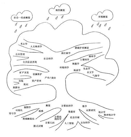
Geography is a discipline that studies human living space, with a long-standing tradition of spatial analysis. It provides GIS with various spatial analysis methods and perspectives, forming the theoretical foundation for certain aspects of GIS. Many branches of geography, such as cartography and geodesy, maintain a close and interdependent relationship with GIS. On the other hand, Geographic Information Systems address geographical issues with innovative ideas and technological approaches, fully leveraging the mathematical traditions inherent in geographical research. The disciplines related to GIS are illustrated in Figure 1-10. Fig. 10 GIS related disciplines # Geography is the science that studies the space on which humankind depends for survival. In geographical research, the theory and methodology of spatial analysis have a long-standing history, providing Geographic Information Systems with fundamental perspectives and methods for spatial analysis, thereby forming the theoretical foundation of GIS. In turn, the development of Geographic Information Systems has offered entirely new technological means for addressing geographical issues and has fully leveraged the mathematical traditions inherent in geographical research. Within the geographic system and its external environment, there exists not only the exchange of matter and energy but also the flow of information. This information exchange connects many seemingly unrelated and morphologically diverse elements, collectively influencing the geographic system. A Geographic Information System embodies an informational linkage: diverse data rich in geospatial information, such as images, maps, and charts, which are input by system creators and stored in machines, interconnected through pointers or indexes. System software encodes, decodes, and processes this spatial data. When users issue commands to the GIS, the system interprets them according to predefined protocols, retrieves command information, calls upon internal data to extract relevant information, and responds to the users. This entire process represents a structured flow of information. Thus, Geographic Information Systems not only represent the flows of matter and energy between physical entities in nature through informational forms but, more importantly, directly reflect the informational interconnections within the natural world. By rapidly simulating the outcomes of how these interconnections evolve, GIS achieves the purpose of geographical prediction. In summary, there exists a profound informational connection between nature and humanity. Geographers confront a tangible, natural geographical world, yet perceive a world of geographic information. Geographical research is essentially based on this informational world that coexists with and is equivalent in meaning to the real world. By using the geographic information world to represent the real geographic world, GIS can authentically and rapidly simulate various natural and cognitive processes, playing a vital role in geographical research and prediction. Maps are a graphical language form for recording geographic information. From a historical development perspective, Geographic Information Systems originated from cartography, and cartographic theory and methods have significantly influenced the evolution of GIS. GIS represents a new form of carrier for map information, possessing functions for storing, analyzing, displaying, and transmitting spatial information. In particular, computer cartography provides a series of methods for the digital representation, manipulation, and display of map features, offering technical support for the graphical output design of GIS. At the same time, maps remain one of the most important data sources for GIS today. However, there is a fundamental distinction between the two: maps emphasize data analysis, symbolization, and display, whereas GIS places greater emphasis on information analysis. Maps are a common means of understanding and analyzing the objective world, although there have been various changes in the form of maps,which can be considered that there are three main factors that constitute maps: map graphics, mathematical elements and auxiliary elements. The map graphic is the content part (also known as the geographical element) of the distribution, connection and time change of various natural and socio-economic phenomena in the drawing area represented by the map symbol, such as rivers and mountains, plains, soil vegetation, residential areas, roads, administrative boundaries, or other thematic content, etc., which are the main parts of the map components. The mathematical element is the mathematical basis for determining the position and geometric accuracy of the graphic, and is the “skeleton” of the map. These include map projections and coordinate networks, scales, and earth control points. Map projection is the mathematical method of mapping the image on the ellipsoid of the earth to a plane; the coordinate network is the mathematical basis of various maps and is an indispensable element on the map; the scale indicates the degree of reduction of the coordinate network and the map graphic; the earth control point is to ensure that the natural surface of the earth is transferred to the ellipsoid surface and then transferred to the plane rectangular coordinate network with precise geographical position. Auxiliary elements are set for easy reading and drawing. The illustration is a description of the various symbols showing the contents of the map, as well as the name of the map, the map compiling and publishing unit, the time of the drawing and the information used, and the date of publication. Some maps also have additional information to supplement and enrich the content of the map. For example, draw some supplementary maps or sections, charts, etc. Sometimes there are also tables or focused textual explanations on specific subjects. It can be seen from the development process of GIS that there is a close relationship between the generation and development of GIS and the mapping system, the similarities between the two are based on the expression, display and processing of spatial databases. From the perspective of system composition and function, a geographic information system has all the components and functions of the machine assisted mapping system, and the geographic information system also has the function of data processing. Map is a kind of graphic image, a geographical model of scientific abstraction and symbolic representation of the real world according to geographical thoughts, the product of geographical thinking and the efficient carrier of geographic information in the physical world, the map can be from different aspects and different topics, systematic recording and transmission of historical, historical and planned predicted geographic landscape information of the physical world. The creation and development of GIS technology is inseparable from the continuous development of the expression, processing, analysis and application of geospatial information. In the early 1960s, computerized digital maps appeared on the basis of computer graphics. Geographic information systems are closely related to computer database technology (DBMS), computer-aided design (CAD), computer-aided drafting (CAM), and computer graphics. But they cannot replace the role of geographic information systems. A Database Management System (DBMS) is a software system for operating and managing databases, providing capabilities for the creation, updating, querying, and maintenance of databases that can be accessed by multiple applications and users. In data management, Geographic Information Systems (GIS) draw on the theories and methods of DBMS. Non-geometric attribute data is sometimes managed using general-purpose DBMS or software systems developed thereon. However, for managing spatial geographic data, general-purpose DBMS exhibits two significant weaknesses: First, it lacks the ability to define spatial entities. Currently prevalent network, hierarchical, and relational structures are inadequate for comprehensively, flexibly, and efficiently describing spatial structures. Second, it lacks spatial relationship query capabilities. Queries in general-purpose DBMS primarily target entities, whereas GIS requires queries based on spatial relationships among entities, such as direction, distance, containment, adjacency, intersection, and spatial coverage. Clearly, general-purpose DBMS struggles to achieve spatial queries and spatial analysis of geographic data. Data serves as the carrier of information, and interpreting data extracts information. Both general-purpose databases and geographic databases focus on managing the data itself. In contrast, GIS builds upon data management by performing geographic model operations to generate useful geographic information. The quantity and quality of information obtained are closely related to the sophistication of the geographic models. Computer graphics is a technology that utilizes computers to process graphical information and facilitates human-computer interaction through graphical information. It serves as the foundation for GIS algorithm design. GIS has continuously evolved and improved alongside the development of computer graphics technology. However, the graphical data processed by computer graphics lacks geographic attributes, consisting purely of geometric shapes that represent geometric abstractions of geospatial data. While it can implement underlying graphical operations in GIS, it cannot perform geographic model analysis or handle many geographically meaningful data processing tasks, thus falling short of constituting a complete GIS. Computer-Aided Design (CAD) assists designers through computer technology to enhance the level of design automation, thereby saving labor and time. Computer-Aided Mapping (CAM), specifically used for cartography, employs computers for editing and drawing geometric graphics. The differences between GIS and CAD/CAM lie in the following aspects: First, CAD cannot establish geographic coordinate systems or perform geographic coordinate transformations. Second, GIS handles significantly larger data volumes with more complex structures and tighter inter-data relationships compared to CAD and CAM. This is because GIS covers extensive regions, requires high precision, involves complex changes and numerous interconnected elements, making it difficult to fully describe with a single structure. Third, CAD and CAM lack the spatially query and analysis capabilities that hold geographic significance in GIS. Remote sensing is a novel detection technology that acquires information about a target without direct contact. It typically refers to the technology of obtaining and processing information about the Earth’s surface, particularly regarding natural resources and the human environment, ultimately reflected in photographs or digital images. Images often require further processing before they can be used, and the technology used for this purpose is called image processing. Image processing includes various operations that can be performed on photographs or digital images, such as image compression, image storage, image enhancement, processing, and quantitative image pattern recognition. Currently, remote sensing has become an extremely valuable tool in environmental studies, with professionals from various disciplines continuously discovering potential applications of different aerial remote sensing data in their respective fields. Remote sensing and image processing technologies are used to acquire and process information related to the Earth’s surface, while the development of GIS stems from the need to integrate land attribute information with corresponding geometric representations and spatial analysis. These two technologies have developed independently in the past, although they are actually complementary. From the perspective of GIS itself, as its application areas expand and deepen, it first requires the storage of large amounts of relevant data. Through continuous accumulation and extension, it gains the ability to reflect trends in natural historical processes and human impacts, revealing the inherent laws of development. However, GIS databases are almost exclusively established through map digitization, preventing users from accessing original data and related information, even though original data in GIS is the foundation for effectively simulating and controlling error propagation. Furthermore, to maintain the dynamism and currency of the system, GIS requires timely updates of the data within the system. Currently, the information stored in GIS is only a static model of the real world and needs regular or timely updates. Remote sensing, as a powerful means of acquiring and updating spatial data, can promptly provide accurate, comprehensive, and large-scale dynamic monitoring data on various resources and the environment. Therefore, remote sensing information has become a very important data source for GIS. On the other hand, data in GIS can serve as auxiliary data for remote sensing image analysis. In the integration process of the two, GIS is mainly used for data processing, manipulation, and analysis, while remote sensing serves as a means of data acquisition, maintenance, and updating of data in GIS. Additionally, GIS can be used for knowledge-based remote sensing image analysis. GIS and remote sensing are two technologically fields that have developed independently. As their application areas continue to expand and they evolve from qualitative to quantitative, from static to dynamic, and from describing the current situation to predicting and forecasting, their integration has gradually progressed from lower to higher stages. The integration of remote sensing and GIS has undergone a development process from lower to higher stages. The earliest integration work involved the visual interpretation and processing of aerial remote sensing photos to compile various types of thematic maps, which were then digitized and input into GIS. Starting from the mid-to-late 1970s, various image analysis systems developed rapidly and extensively. Large amounts of remote sensing data and various types of thematic information formed by image classification in image analysis systems can be directly input into GIS. The entire process can be conducted in a “fully digital” environment, and image data can be displayed on screens for editing maps, marking the entry of the integration of remote sensing and GIS into a new stage. Remote sensing, as a means of spatial data acquisition, has become a primary information source and data update channel for Geographic Information Systems. Remote sensing image processing systems incorporate numerous complex analytical functions and offer various methods for information enhancement and classification. Furthermore, geodesy provides GIS with precisely positioned control systems, particularly through the Global Positioning System (GPS), which enables rapid and cost-effective acquisition of accurate positional data for surface features. The application of aerial photographs and their precise measurement techniques has established photogrammetry as a major source of topographic data for GIS. In summary, remote sensing serves as a crucial data source and updating mechanism for GIS, while GIS applications further enhance the comprehensive development and utilization of remote sensing information. Management Information Systems (MIS) in the traditional sense are computer-supported information systems designed for administrative purposes, capable of storing, processing, managing, and analyzing data, such as talent management MIS, financial management MIS, and service industry MIS. The most distinctive feature of such systems is that the data they handle lacks or does not include spatial characteristics. Another category of management information systems is goal-oriented systems supported by Geographic Information Systems (GIS) with spatial analysis capabilities. These systems utilize various functions of GIS to process and analyze spatially characterized elements, thereby achieving the purpose of managing regional systems. Examples include urban traffic management information systems, urban water supply management information systems, and water-saving agricultural management information systems. In fact, the relationship between GIS and other disciplines can be visually represented by a tree, as shown in Figure 1-11. Fig. 11 GIS subject “tree” [Charistopher.B.Jones] # As illustrated in the figure above, the “roots” represent the technical foundations of GIS, such as surveying, computer science, and mathematics; the “branches” signify the applications of GIS, with the outcomes and demands of these applications feeding back to the “roots”; the “raindrops” symbolize the data sources for each application, including various types of surveys such as topographic and environmental surveys, which provide essential means for its development. The applications of GIS primarily span fields such as environmental science, geography, and social sciences.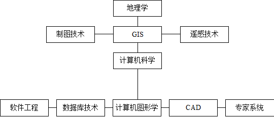
Geography #
Cartography #
Computer science #
Remote sensing #
Management science #