From Laboratory GIS to Socialized GIS #
In the early stage of the development of GIS, it is only a technology mastered by a few scientific researchers. They use various GIS tools and software, even write their own programs, process spatial data, realize professional models, and get the results of their research work. A large number of GIS scholars mainly study algorithms and data structures. For the general public, GIS is considered to be difficult to understand, and they are not aware of the possible application areas of GIS technology and its impact on social life. At this time, GIS is called Lab GIS.
Because of the development and popularization of computer computing technology, especially the maturity of network technology and database technology, many organizations begin to apply GIS to manage spatial information, and then realize spatial decision support, in order to improve work efficiency and reduce enterprise operation costs. This application of GIS is called “enterprise GIS”. Enterprise GIS can be summarized eight characteristics (Chen Zitan):
Distributed network computer environment: Distributed computing based on network enables all departments of enterprises to share resources, including data, equipment, software and so on.
Function-oriented:In order to meet the requirements of various departments for GIS, enterprise-based GIS needs to provide a variety of functional services, to ensure that all departments in accordance with their requirements to use.
Continuous seamless spatial database: In order to achieve more effective and reasonable management of the real world, spatial data need to be stored continuously in the form of the real world, instead of being segmented into different maps.
Version management of data: In the daily use of enterprise GIS, data changes are frequent. Version control is needed to ensure the validity of data and avoid confusion.
Coexistence of data and systems at different levels: Enterprise tasks are multi-level, which requires the use of different systems and databases at the same time.
Connect with multiple external databases.
Open system environment: Open environment enables an enterprise-oriented GIS to be closely integrated with other fields, and to meet the needs of system expansion.
Professionals of comprehensive GIS system management: Enterprise-based GIS has higher requirements for technology and management personnel, which requires continuous technical and management training for personnel.
In the application of enterprise GIS, the main research fields of GIS scholars include the implementation of GIS based on distributed computing platform, the sharing and interoperability of spatial data, and the management of GIS projects.
In the initial stage of enterprise GIS application, its application mainly focused on some departments which often need to process and use spatial data, including land, municipal facilities management and so on. The business data of these departments have “strong” spatial distribution characteristics, such as plot data, pipe network data, etc. It is “natural” to use GIS to manage their business. With the popularization of information technology applications, many organizations in other fields begin to use GIS, such as: shopping malls can use GIS to analyze the shopping tendency of customers in different regions; wireless communication departments can use GIS to determine the coverage and coverage efficiency of their transmitting stations; and transportation departments can use GIS to analyze traffic flow. In these organizations, spatial data is only a part of the data in the information system, or the data in the information system, such as customer and employee data, the “weak” [1]_ spatial distribution characteristics, GIS is integrated with other systems to serve its business.
With the expansion of the application field of GIS, the application level of spatial data is also improving. From simple data management to complex spatial decision support, GIS can meet the different functional requirements of various organizations. The development of remote sensing and GPS technology has provided new data sources for GIS. Multi-source and massive spatial data are generated and applied. The above changes require data sharing, integration and distribution management. The distributed computing platform based on network provides a technical basis for it. At the same time, the establishment of GIS standard (including ISO/TC211, OpenGIS, etc.) ensures the realization of data sharing, integration and distribution management by standardizing spatial data model and spatial service model and establishing standard distributed computing interface. Under the above background of application and technology development, GIS has entered the stage of social application (Figure 18-1). Fig. 260 Figure 18-1: Socialization of Geographic Information Systems # 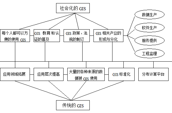
Impact of GIS Socialization #
There are some other synonyms for the socialization of GIS, such as “globalization”, “popularization” and so on. They actually describe different aspects of the socialization of GIS.
“Popularization” is the main aspect of GIS socialization. It means that GIS technology has been integrated into people’s daily life, and migration has changed the way of life imperceptibly:
By storing maps in computers, the functions of positioning, orientation and navigation provided by maps can be realized through GIS, while 3S integration technology can make the functions of positioning and navigation be more automated and accurate;
By using GIS, information can be organized according to its spatial coordinates and queried; so
It can analyze its spatial distribution characteristics and provide decision support.
GIS can play a role in all aspects of people’s life, such as the vehicle navigation, field exploration and tourism, bank credit card management, business operation analysis, insurance compensation analysis and so on. When this level of application expands from a region, a country to the whole world, and the global spatial information is managed based on GIS technology, the “digital earth” is realized. It can be considered that the “digital earth” is the ultimate application of GIS and the vertex of the socialization of GIS.
The public uses GIS in daily life, but he or she does not need to know any knowledge of GIS. In other words, he or she does not feel the role of GIS as an independent technology. Just like an ATM system based on database, when people deposit or withdraw money, they do not need to know the query, modification and submission of database. The concepts and implementations of specific functions need not to know for people, such as return, but it is true that they uses these functions. At this time, GIS applications and other applications are closely integrated, and have become an inseparable part of people’s daily production and life. As some scholars predicted, “The future of GIS development is without GIS”.
From the application point of view, the socialization of GIS means that everyone can easily use the functions of GIS. From the perspective of application development, the sign of GIS socialization is the formation and differentiation of GIS industry, the formation of specialized data producers, GIS platform/component developers, GIS integrators, GIS service providers and GIS engineering supervision, etc. The establishment of relevant GIS technical standards provides a basis for the development of GIS industry. The development of GIS industry needs a large number of professionals, which promotes the development of GIS education and certification. In addition, the government and legislative departments need to formulate corresponding policies and regulations to ensure the orderly operation of the industry (Fig. 18-1).