Remote Sensing (RS) is a science and technology that obtains its characteristic information and extracts, processes, expresses and applies it through a kind of sensor device without direct contact with the research object.
As a term, remote sensing appeared in 1962. The rapid development and wide use of remote sensing technology in the world came after the successful launch and acquisition of a large number of satellite images by the first Earth Resources Technology Satellite (LANDSAT-1) of the United States in 1972. In recent years, with the development of geographic information system technology, remote sensing technology and its close combination, the development is more rapid.
The basis of remote sensing technology is to interpret and analyze the targets and phenomena of the earth’s surface by observing electromagnetic waves. It utilizes the electromagnetic wave characteristics of the earth’s objects, that is, “all objects have the characteristics of reflecting or radiating electromagnetic waves of different wavelengths because of their different types and environmental conditions” (Fig. 12-1). So remote sensing can also be said to be a method of using objects to reflect or radiate electromagnetic waves. The inherent characteristics of the object, through the observation of electromagnetic waves, identify the object and the existence of environmental conditions of the object technology. Fig. 188 Electromagnetic reflection curves of several common ground objects (water, green vegetation, bare dryland) # 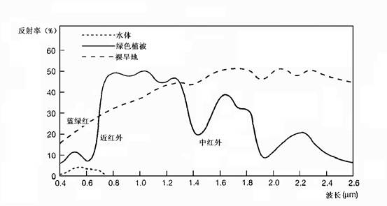
In remote sensing technology, the devices receiving electromagnetic waves reflected or radiated from the target are called remote sensors, and the mobile objects carrying these remote sensors are called remote sensing platforms, including airplanes, satellites, and even ground observation vehicles belong to remote sensing platforms. Aerial Remote Sensing is commonly referred to as the airborne platform, while the spaceborne platform is called the space remote sensing.
According to the working principle of remote sensing, remote sensing can be divided into passive remote sensing and active remote sensing. Each mode can be divided into scanning mode and non-scanning mode. MSS (Multispectral Scanner) and TM (Thematic Mapper) used by land satellites belong to passive and scanning mode (Figure 12-2). SAR-Synthetic Aperture Radar (SAR-Synthetic Aperture Radar) is an active and scanning remote sensor. Fig. 189 Schematic diagram of a multispectral scanner [Curran] # 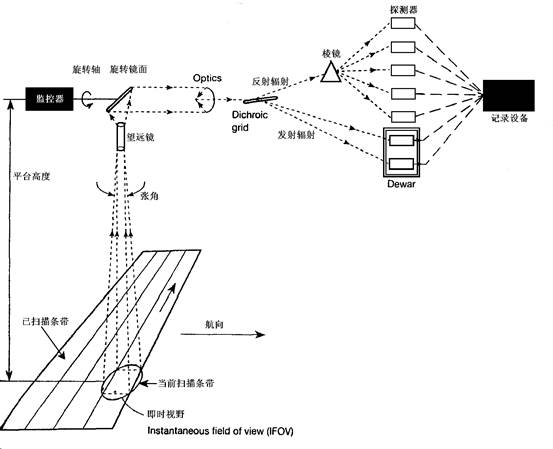
From the definition of remote sensing, we can see that, firstly, the remote sensor does not contact with the research object directly, that is to say, the “remote” here does not mean “remote”; secondly, the purpose of remote sensing is to obtain the characteristic information of the research object; finally, the data obtained through the sensor device will go through a processing process before being used. Figure 12-3 describes the process from acquiring remote sensing data to application. Fig. 190 Remote sensing data process # 
Processing of remote sensing data, usually in the form of images, mainly includes correction (including radiation correction and geometric correction), enhancement, transformation, filtering, classification and other functions. Its main purpose is to extract various thematic information, such as land construction, vegetation coverage, crop yield and water depth, etc. (Figure 12-4). Remote sensing image processing can adopt optical processing and digital processing. Digital image processing is widely used because of its good repeatability and easy integration with GIS. Following is a brief introduction to the main functions of digital image processing. Fig. 191 TM composite image near Donghu Lake, Wuhan City. Ships on the Yangtze River are clearly visible. # (Synthetic scheme: R = TM7, G = TM4, B = TM2, enhanced)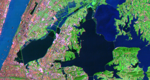
1) Image Correction
Image correction is a process of eliminating image distortion, including radiation correction and geometric correction. Radiation distortion is usually caused by solar position and atmospheric absorption and scattering. Geometric distortion (Figure 12-5) is caused by velocity, attitude change of remote sensing platform, sensor and topographic fluctuation. Geometric correction includes rough correction and precise correction. The former is corrected according to relevant parameters. The latter is constructed by collecting ground control points (GCPs, Ground Control Points). Correction polynomials are established and corrected. Fig. 192 Geometric distortion of remote sensing images [Lillesand and Kiefer] # 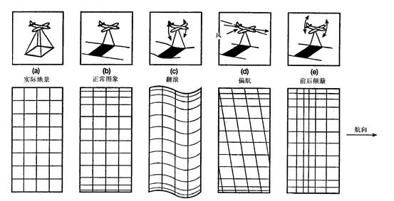
2)Enhancement
The purpose of enhancement is to improve the visual effect of the image, without increasing the amount of information, including brightness, contrast change and histogram transformation.
3)Filtering
Filtering is divided into low-pass filtering, high-pass filtering and band-pass filtering. Low-pass filtering can remove noise in images, while high-pass filtering is used to extract some linear information, such as roads, regional boundaries and so on. The filtering can be operated by filtering template in spatial domain or directly in frequency domain.
4)Transformation
It includes Principal Component Analysis (PCA), chromaticity transformation and Fourier transform. It also includes some specific transformations for remote sensing images, such as hat transformation.
5)Classification
The main purpose of using remote sensing images is to extract various kinds of information. Some specific transformations can be used to extract information, but the main method is to classify remote sensing images. The basic principle of computer classification is to calculate the gray level characteristics of each pixel in the image and classify them according to different criteria. There are two classifications for remote sensing image classification: Supervised Classification and Unsupervised Classification. The former needs to determine each class and its training area beforehand, calculate the gray level statistical characteristics of training area pixels, and then merge other pixels into different classes. The latter is based on the similarity and similarity between gray level features of pixels directly. Different degrees of merger and differentiation, forming different categories. Typical supervised classification algorithms include minimum distance method, maximum likelihood method, parallel hexahedron method, etc. K-means clustering belongs to unsupervised classification. Applying ANN (Artificial Neural Network) to remote sensing classification can achieve better classification results in some cases.
The emergence of remote sensing has expanded human’s ability to understand their living environment. Compared with the data obtained from traditional field surveys and field observations, remote sensing technology has the following advantages:
The observation range is enlarged.
It can provide a wide range of instantaneous static images for monitoring dynamic changes.
It can carry out large-scale repetitive observation, even in remote areas which are difficult for human beings to reach.
The spectrum range that the human eye can observe is greatly broadened, and the electromagnetic wave band used in remote sensing is far beyond the visible light range from X-ray to microwave, while radar remote sensing can observe all-weather without restriction of day and night and weather change due to the use of microwave.
With high spatial detail, the spatial resolution of aerial photographs can be as high as centimeter level or even millimeter level.
Compared with aerial remote sensing, aerospace remote sensing can perform continuous, all-weather work, provide a larger range of data, and its cost is lower, which is the main way to obtain remote sensing data; while aerial remote sensing is mainly used in temporary and urgent observation tasks to obtain high-precision data. At present, many countries in the world have launched various remote sensing satellites for different purposes, and the spatial and spectral resolution of their remote sensors are also different, forming a series of ground observation data sources from coarse to fine, which can be used to monitor information and its dynamic changes from land use, crop growth, vegetation cover to floods, forest fires, pollution and other phenomena.
In a word, remote sensing technology can monitor environmental information more quickly and objectively. At the same time, because of the spatial distribution characteristics of remote sensing data, it can be used as an important data source of Geographic Information System to update the spatial database in real time.
Table 12-1: Several commonly used remote sensing satellites and their remote sensor parameters
Satellite sensor | Band ( μ m) | Spatial resolution | Coverage area | Cycle | Main use |
Landsat TM | 0.45-0.52 0.52-0.60 0.63-0.69 0.76-0.90 1.55-1.75 10.4-12.4 2.05-2.35 | 30m (1-5pm 7 band) | 185km × 185km | 16 days | Water depth, water color Water color, vegetation Chlorophyll, residential area Plant growth Soil and plant moisture Cloud and surface temperature Rock type |
SPOT-HRV | 0.50-0.59 0.61-0.68 0.79-0.89 0.51-0.73 | 20m 20m 20m 10m | 60km × 60km | 26 days | Water color, plant condition Chlorophyll, residential area Plant growth Drawing |
NOAA-VHRR | 0.58-0.68 0.72-1.10 3.55-3.93 10.3-11.3 11.5-12.5 | 1.1km | 2400km × 2400km | 0.5 days | Plants, clouds, ice and snow Plants and the boundary between water and land Hot spots, night clouds Cloud and surface temperature Atmospheric and surface temperature |
IKONOS [1]_ | 0.45-0.9 0.45-0.52 0.52-0.60 0.63-0.69 0.76-0.90 | 0.82m 4m 4m 4m 4m | 11km × 11km | 14 days |
Principles, Technologies, and Methods of Geographic Information Systems 102 In recent years, Geographic Information Systems (GIS) have undergone rapid development in both theoretical and practical dimensions. GIS has been widely applied for modeling and decision-making support across various fields such as urban management, regional planning, and environmental remediation, establishing geographic information as a vital component of the information era. The introduction of the “Digital Earth” concept has further accelerated the advancement of GIS, which serves as its technical foundation. Concurrently, scholars have been dedicated to theoretical research in areas like spatial cognition, spatial data uncertainty, and the formalization of spatial relationships. This reflects the dual nature of GIS as both an applied technology and an academic discipline, with the two aspects forming a mutually reinforcing cycle of progress.
|