More and more organizations are developing GIS, but according to the survey, a large number of GIS systems can not really complete and operate normally. Most of the failures of these projects are not caused by technical problems, but by organizational and management problems, and the failure to carry out detailed project planning is the fundamental reason. Project planning includes strategic planning and implementation planning, the former is carried out before the project officially launched, while the latter is often the first step of project implementation.
Factors causing by failure of Geographic Information System development [Junzhi Murakai] , from the opposite point of view, it explains how to develop a successful application of geographic information system. Fig. 231 Factors contributing to the failure of GIS development # 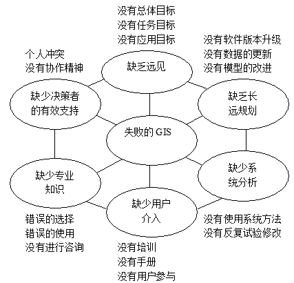
Application project strategic planning corresponds to the identification requirement stage of project life cycle. The main purpose is to determine what kind of GIS application should be established, and to organize the existing conditions, including funds, personnel, equipment, sites and so on, to support the establishment and application of GIS. If the user develops the GIS system by himself, it may include the choice of the system development plan. On the contrary, the developer usually proposes the solution.
The strategic planning of GIS projects generally includes five main parts:
Institutional status analysis and investigation: From the perspective of GIS, we can understand the current organization, tasks and technical status of an organization, including the scope of responsibility, development goals, technical force, attitude towards the use of information technology and GIS, human, material and financial status, etc. Conditions analysis and investigation provide a conceptual basis for further planning.
Development objectives of Institutional GIS System: Define the development direction of GIS, which should be consistent with the tasks and responsibilities. It should make a clear definition of the capabilities of all aspects of the whole system. The process of setting the general direction requires the participation of the elevation managers in the organization. Their understanding of the whole system development will be helpful to the development of the whole system.
Feasibility of system development: It mainly includes three aspects: capital, technical force and organizational operation. The analysis of funds should take into account the whole process of GIS implementation, operation and maintenance, and the common method is cost-benefit analysis. In terms of technical feasibility, it is necessary to consider whether the technology required in the GIS project can be satisfied. The development and the impact of new technology and technical training are needed for personnel. Organizational aspects include whether the whole organization is willing to bear the changes brought by the introduction of GIS technology and whether they can cooperate with each other in the development process to complete the development tasks.
Scheme selection of system development: The scheme selection of system development covers all aspects of GIS system, including data part, function part, the whole software and hardware framework of the system, in order to determine the implementation departments, schedule and management methods of each aspect.
Drafting of decision planning for GIS System: After the strategic planning is completed and approved, if the system is developed by users themselves, the following development work can be carried out directly. If it needs to be developed or contracted by another GIS developer, it can be submitted to the developer in the form of RFP (Request for Proposal), and the developer takes it as an important basis for demand analysis. Besides, some achievements of strategic planning are also reflected in the contract.