The background and concept of Digital Earth
The concept of Digital Earth (DE) first appeared in the second half of 1997. In 1998, Gore formally put forward the concept of Digital Earth in a speech. The proposal of digital earth is based on the achievements of human scientific and technological development, and it has its profound social and economic background。
The scientific background of digital earth includes a series of disciplines such as geographic information science and geo-information science. The development of these disciplines has laid a theoretical foundation for the emergence of digital earth. The development of earth observation system and computer network have provided technical support for digital earth. The study of global change and sustainable development has played a driving role in the emergence of digital earth. (Figure 19-2)
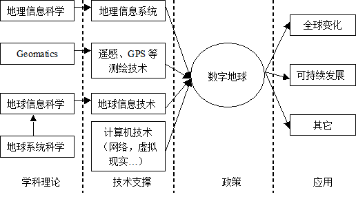
Figure 19-2: The relationship among digital earth and other theories and technologies
The basic concepts of digital earth can be summarized in the following three aspects:
Digital Earth refers to the virtual earth with three-dimensional digital display, or the information-based earth, including digital, networked, intelligent and visualized earth technology system;
The implementation of the Digital Earth Project requires the joint efforts of the government, enterprises and academia. The implementation of the Digital Earth Project is a social behavior, which needs the concern and support of the whole society;
Digital Earth is a new technological revolution, which will change human production and life style, further promote the development of science and technology and promote social and economic progress。
Compared with a series of disciplines such as Geo-Information Science, Geographic Information Science, Geomatics and other technical terms such as remote sensing, GPS, Internet, etc., Digital Earth is more like a technical policy, covering the above-mentioned areas to a certain extent, “more popular and understandable, is a call for society, in essence, digital earth is to require the realization of all information on the earth. Characterization” [Chen Shupeng] 。
The basic technology of digital earth is composed of remote sensing, telemetry, geographic information system, Internet and so on. Remote sensing and telemetry provide the means to acquire data. Geographic information system manages, stores, analyses and displays data, and transmits and publishes data through internet. This constitutes the basic framework of digital earth technology system (Figure 19-3)。
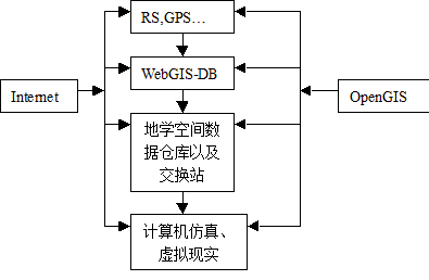
Figure 3: Basic framework of Digital Earth technology
Digital Earth: Looking ahead to the 21st century, our planet was published at the California Science Center on January 31, 1998 (Al.Gore)
The new wave of technological innovation has enabled us to obtain, store, process and display vast amounts of information about the various environmental and cultural phenomena of our planet. Such a large amount of information constitutes a “geographic coordinate system”, which involves every specific place on the earth’s surface。
Using satellite remote sensing to form the “Earth Space” (Orbit) information flow, and transform the data of unprocessed useful parts into usable information. Today, we often find that we can get more information than we know what to do. A typical example is that the Earth Resources Technology Satellite (ERT) can help us better understand the global environment. The Earth Resources Technology Satellite (ERTS) can complete the surface imaging every two weeks, and it has been collecting data for more than 20 years. Despite the huge demand for this kind of information, most of the images can not be used by people. Therefore, they can only be stored in electronic databases. We used to have agricultural policies like this. When millions of people were dying of hunger, there were lots of mouldy grain stored in the cellars of the Midwest. On the one hand, we are showing the insatiable hunger for knowledge, on the other hand, a large amount of data is still not used at all。
One of the questions is how to display the information. Some people have said whether we can try to use computer terms to describe the human brain. However, the human brain seems to have a lower bit rate than the computer, but it has a very high resolution. For example, studies have shown that because of the low brain-to-brain ratio, it is difficult to remember more than seven data in a short time. However, if the information is listed in a mutually recognizable model, such as the human face or galaxy, the human brain can absorb thousands of information at the same time。
In the past, we used to use desktop graphics provided by Macintosh and Windows operating systems for human-computer dialogue. In fact, these tools are not suitable for new challenges now. I believe we need a “digital earth”, a variety of resolution, a three-dimensional representation, so that we can embed a huge number of geographic coordinate data. For example, imagine a young child visiting a digital earth exhibition in a local museum. After wearing a display helmet, she saw the Earth emerge from space, magnifying electronic images with data gloves. Using ever higher resolution, she saw the mainland, then the countryside, then the city, and finally private housing, trees and other natural and artificial materials. She uses a 3D view of the terrain similar to a “magic carpet ride” and is interested in exploring the planetary areas she is seeing. Of course, terrain is just one of the many data that she can interact with. Using the voice recognition system, she can request information about land cover, species distribution of plants and animals, real-time weather, roads, political scope and population. She can also externalize the information she and other students collect as part of the global environment. This information can be seamlessly integrated into digital maps or topographic data. By clicking a connection button with a data glove, she can get more detailed information about what she sees. For example, in preparation for her family’s holidays in Yellowstone National Park, she plans to go on foot to see natural fountains. She has just read about bison and Rocky goats. In fact, she was able to make virtual trips before she left the museum in her hometown。
She can travel through space without restriction, as well as through time. After a virtual tour to Paris to see the Louvre, she learned French history by moving backwards in time, read digitized maps, newsreels, oral history, newspapers and other major raw materials covered by the digital earth’s surface. She sends some useful information to her e-mail so that she can study in the future. Time series can take days, years, centuries, even geological epochs to extend from here to the distant past, because those occasions are conducive to her understanding of dinosaurs。
Obviously, no government, enterprise or academia can do this work alone. Like a global network, it requires the joint efforts of thousands of private, corporate, university researchers and government organizations. Although some of the data as digital earth are public information. But Digital Earth can also become a digital market for companies that sell large amounts of commercial images and paid information services. It can also become a “wall-free laboratory” where scientists can seek to understand the complex and interdependent relationship between human beings and the environment through research。
Technologies to create a digital earth
Although these scenarios may seem like science fiction stories, most of the technologies and capabilities needed to build a digital Earth are either here or under development. Of course, the capabilities of the digital earth will evolve over time. We will be able to make a primitive comparison of the digital earth of 2020 in 2005. Some of the following technologies are needed:
Computational Science: Until the advent of computers, experimental and theoretical methods of creating knowledge have been limited for a long time. It is too difficult for experimental scientists to observe the phenomena to be studied. These phenomena are either too small or too large, or too fast or too slow. They exist in less than a billionth of a second or more than a billion years. On the other hand, pure theory cannot predict natural phenomena as complex as thunderstorms or airflow on aircraft. As high-speed computers begin to be used as new tools, we can simulate phenomena that are not easy to observe, and at the same time we can better understand the observed data. In this way, computational science allows us to break through the limitations of experimental and theoretical science. Simulations will give us new insights into the data when we are collecting about our planets。
Large-scale Storage: Digital Earth will require storage 1015 byte information. Later this year, NASA’s planetary program will generate a lot of information about the earth every day. Fortunately, we continue to make dramatic improvements in this area。
Satellite Image: As early as 1998, the government has licensed commercial satellite systems that provide resolution image processing services to start operating. Such services enable map mapping to achieve a sufficient level of accuracy, whereas detailed information on the original map can only be obtained through aerial photography. This technology was first developed by the American Intelligence Organization with incredible accuracy. When a company uses this technology, it looks like a powerful camera, and in its pictures it can clearly see everything from London to Paris, the width of a car headlight。
Network: The data needed for digital Earth will be maintained by thousands of different organizations, not a single database. That means that servers in use on the digital earth will need to be connected to high-speed networks. Driven by the explosion of Internet traffic, telecom operators have been experimenting with networks of 10 Gbps per second. 10Gbps network technology is one of the next generation technology goals of Internet. The bad news is why digital earth is necessary to build interfaces in public places such as children’s museums and science museums before most of us have such broadband in our homes。
Interoperability: The key to the success of the Internet and the Global Network is to reach a unified agreement, such as Internet protocol. Digital Earth also needs interoperability. In this way, the geographic information generated by the application software can be read by others. The GIS industry is looking for ways to solve these problems through the GIS Association。
Metadata: Metadata refers to “data about data”. Understanding the name, location, author or source of information, data, data form, resolution and so on will help to establish other geographic coordinate information systems. The Federal Geographic Data Commission is working with industry, state and local governments to develop unofficial Metadata standards。
Potential applications: The application of global geographic information systems is sometimes limited by our imagination. We can feel these applications through the current use of GIS and data sensors:
Virtual Diplomacy: To support peace negotiations in Bosnia, the Pentagon has developed a virtual reality scenario that allows negotiators to make a virtual border tour. During the negotiations, when the Serbian President saw through virtual border tourism that the original narrow corridor was impractical, he agreed to provide a wide corridor between Sarajevo and the occupied Islamic territory of Gorazide。
Combating Criminals: Police in Salina, California, have used GIS to track crime models and gang activities to reduce gun-related violence among teenagers. By collecting information on the frequency and distribution of criminal activities, cities can rapidly redeploy police forces。
Conservation of ecological diversity: California’s population is projected to increase from 1.1 million in 1990 to 1.6 million in 2010, according to the planning agency in Camp Pendelton. More than 200 species of plants and animals are protected by federal or state governments as endangered, threatened, or rare. By collecting information about topography, soil types, annual rainfall, plants, land use and ownership, scientists simulated the impact of different regional growth plans on ecological diversity。
Forecasting climate change: One of the most significant unknown factors in simulating climate change is the decline rate of global forests. Researchers at the University of New Hampshire, working with colleagues in Brazil, are able to monitor land-form changes in the Amazon River basin through satellite imagery analysis so that they can determine forest decline rates in the basin. This technology is now being used in other forest areas of the world。
Increasing agricultural productivity: Farmers have begun to use satellite imagery and global positioning systems to prevent pests and diseases in a timely manner, and to use pesticides, fertilizers and water where they are most needed. This is called intensive farming, or “progressive farming in inches”。
Future directions: We have an unprecedented opportunity to translate vast amounts of raw data about our society and the planet into understandable information. These data include not only high-resolution satellite images and digital maps, but also economic, social and demographic information. If we succeed, we will bring broad social and commercial benefits, especially in education, decision support for sustainable development, land use planning, agriculture and crisis management. Digital Earth will give us the opportunity to deal with man-made or natural disasters, or to help us work together in the face of long-term environmental challenges facing mankind。
Digital Earth provides a mechanism to guide users to search for geographic information, which can also be published by producers. Its whole structure includes the following aspects: a user interface for browsing, a three-dimensional earth with different resolutions, a geographic database that can be quickly and substantially networked, and a variety of mechanisms that can integrate and display multi-source data。
It is constructive to compare the Digital Earth with the World Wide Web (in fact, it may be based on several key standards of the World Wide Web and the Internet). Digital Earth, like the World Wide Web, will continue to improve as technology advances and the amount of information available increases. It is not controlled by a single organization, but by public information queries, commercial products and services provided by thousands of different organizations. Just as interoperability is the key to the World Wide Web, the key capability for digital Earth is to find and display data in different formats。
I believe that the development of the digital earth requires to establish a “pilot field” with the participation of the government, enterprises and academia. This “pilot field” will be a convergence of applications such as education, environment, technology issues related to interoperability, collaboration capabilities, and policy issues such as privacy issues. When the “experimental field” is successful and promoted, it can interact with the digital earth through access to high-speed networks in a wider range. Access to the Internet will feel more restrictive。
To be sure, the digital earth did not come into being overnight. In the first stage, we should focus on integrating the data we have from different sources. We should also connect museums and science museums that guide children to high-speed networks, such as the new generation of Internet, so that our children can explore our planet. Secondly, we should strive to develop a one-meter resolution map of the digital world. Ultimately, we should bring a lot of information about our planet and our history to our fingertips。
A few months ago, I planned to encourage experts from governments, businesses, academia and non-profit organizations to develop a strategy to achieve this vision. Together, we can help solve many of the most pressing problems facing society, encourage our children to learn more about the world around them, and promote billions of dollars in industrial economic growth。